Written and Fact-checked by Mukesh Kumar | Updated On: April 256 2026 | 15:50 ET
Map of Rockland County - Rockland County is a county located in the U.S. state of New York. Rockland County Map showing cities, highways, important places and water bodies. Get Where is Rockland County located in the map, major cities in Rockland county, population, areas, and places of interest.
Map of Rockland County, New York
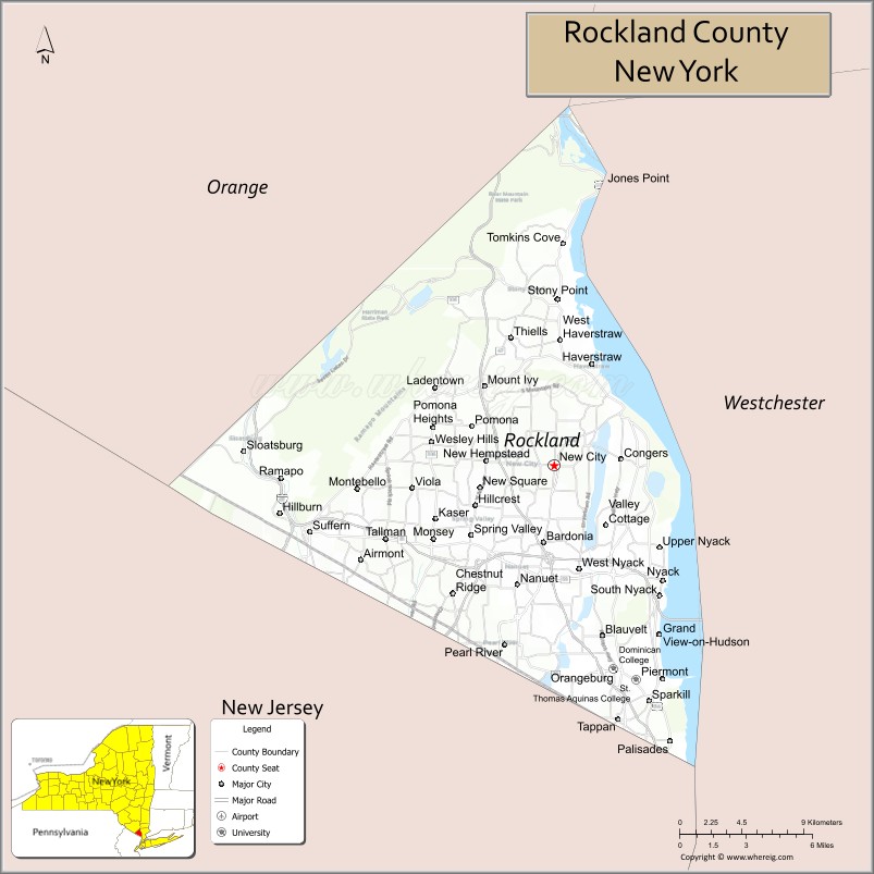
About Rockland County Map, New York: The map showing the county boundary, county seat, major cities, highways, water bodies and neighbouring counties.
Related NY Maps & Info
About Rockland County, New York
Rockland County is a county located in the U.S. state of New York. It's county seat is New City. As per 2020 census, the population of Rockland County is 339227 people and population density is 1704.66 square miles. According to the United States Census Bureau, the county has a total area of 199 sq mi (515 km2). Rockland County was established on 1798.
Facts about Rockland County, New York
| Country | United States |
| State | New York |
| Region | Hudson Valley / New York Metropolitan Area |
| County Seat | New City |
| Founded | February 23, 1798 |
| Named For | Descriptive name referring to its “rocky land” terrain |
| Coordinates | 41.15° N, 74.05° W |
| Total Area | 199 sq mi |
| Land Area | 174 sq mi |
| Water Area | 26 sq mi |
| Water % | 13% |
| Population (2020) | 338,329 |
| Estimated Population (2024) | 348,144 |
| Population Density | 2,006/sq mi (land area) |
| Largest Municipality | Ramapo (town) |
| Other Towns & Communities | Clarkstown, Orangetown, Haverstraw, Stony Point, Piermont, Nyack, Spring Valley |
| Main Industries | Services, Healthcare, Retail, Manufacturing, Research & Education |
| Major Highways | I‑87/I‑287, Palisades Pkwy, U.S. 9W, NY‑303 |
| Time Zone | Eastern Time (UTC−05:00) |
| Known For | Hudson River waterfront, Bear Mountain & Harriman State Parks, vibrant suburban communities |
| Website | https://www.rocklandcountyny.gov/ |
Top Attractions in Rockland County, New York
- Bear Mountain State Park – Hiking and Hudson River views.
- Harriman State Park – Large park with lakes and trails.
- Nyack Village – Shops, dining, and riverfront charm.
- Rockland Lake State Park – Lakeside trails and recreation.
- Stony Point Battlefield State Historic Site – Revolutionary War site.
- Hudson River Walkway – Scenic riverside paths.
- Edward Hopper House Museum – Artist’s historic home.
- Hook Mountain State Park – Riverside hiking trails.
- Haverstraw Brick Museum – Local industrial history.
- Nyack Beach State Park – River views and walking paths.
- Blauvelt State Park Preserve – Forest trails and history.
- Clausland Mountain – Scenic forested area.
Cities & Towns in Rockland County, New York
New City, Nyack, Spring Valley, Haverstraw, Pearl River, Suffern, Nanuet, Blauvelt, Bardonia, Thiells, West Nyack, Congers, Garnerville, Pomona, Valley Cottage, Upper Nyack, Blauvelt, Orangeburg
- Albany County Map
- Allegany County Map
- Bronx County Map
- Broome County Map
- Cattaraugus County Map
- Cayuga County Map
- Chautauqua County Map
- Chemung County Map
- Chenango County Map
- Clinton County Map
- Columbia County Map
- Cortland County Map
- Delaware County Map
- Dutchess County Map
- Erie County Map
- Essex County Map
- Franklin County Map
- Fulton County Map
- Genesee County Map
- Greene County Map
- Hamilton County Map
- Herkimer County Map
- Jefferson County Map
- Kings County Map
- Lewis County Map
- Livingston County Map
- Madison County Map
- Monroe County Map
- Montgomery County Map
- Nassau County Map
- New York County Map
- Niagara County Map
- Oneida County Map
- Onondaga County Map
- Ontario County Map
- Orange County Map
- Orleans County Map
- Oswego County Map
- Otsego County Map
- Putnam County Map
- Queens County Map
- Rensselaer County Map
- Richmond County Map
- Rockland County Map
- St Lawrence County Map
- Saratoga County Map
- Schenectady County Map
- Schoharie County Map
- Schuyler County Map
- Seneca County Map
- Steuben County Map
- Suffolk County Map
- Sullivan County Map
- Tioga County Map
- Tompkins County Map
- Ulster County Map
- Warren County Map
- Washington County Map
- Wayne County Map
- Westchester County Map
- Wyoming County Map
- Yates County Map
- Alabama Counties
- Alaska boroughs
- Arizona Counties
- Arkansas Counties
- California County Map
- Colorado Counties
- Connecticut Counties
- Delaware Counties
- Florida County Map
- Georgia County Map
- Hawaii Counties
- Idaho Counties
- Illinois Counties
- Indiana Counties
- Iowa Counties
- Kansas Counties
- Kentucky Counties
- Louisiana Counties
- Maine Counties
- Maryland Counties
- Massachusetts Counties
- Michigan County Map
- Minnesota Counties
- Mississippi Counties
- Missouri Counties
- Montana Counties
- Nebraska Counties
- Nevada Counties
- New York Counties
- New Hampshire Counties
- New Jersey Counties
- New Mexico Counties
- North Carolina Counties
- North Dakota Counties
- Ohio County Map
- Oklahoma Counties
- Oregon Counties
- Pennsylvania Counties
- Rhode Island Counties
- South Carolina Counties
- South Dakota Counties
- Map of Tennessee
- Texas County Map
- Utah Counties
- Vermont Counties
- Virginia Counties
- Washington Counties
- West Virginia Counties
- Wisconsin Counties
- Wyoming Counties