Written and Fact-checked by Mukesh Kumar | Updated On: April 256 2026 | 15:50 ET
Map of Bronx County - Bronx County is a county located in the U.S. state of New York. Bronx County Map showing cities, highways, important places and water bodies. Get Where is Bronx County located in the map, major cities in Bronx county, population, areas, and places of interest.
Map of Bronx County, New York
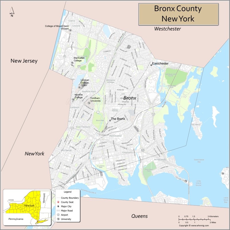
About Bronx County Map, New York: The map showing the county boundary, county seat, major cities, highways, water bodies and neighbouring counties.
Related NY Maps & Info
About Bronx County, New York
Bronx County is a county located in the U.S. state of New York. It's county seat is none (sui generis). As per 2020 census, the population of Bronx County is 1424948 people and population density is 24811.91 square miles. According to the United States Census Bureau, the county has a total area of 57.43 sq mi (149 km2). Bronx County was established on 1914[8].
Facts about Bronx County, New York
| Country | United States |
| State | New York |
| Region | New York City / Southern New York |
| County Seat | The Bronx (coextensive with county) |
| Founded | January 1, 1914 |
| Named For | Jonas Bronck, early settler (Broncksland) |
| Coordinates | 40.84° N, 73.86° W |
| Total Area | 109 sq mi (42 sq mi land) |
| Land Area | 42 sq mi |
| Water Area | 67 sq mi |
| Water % | 61% |
| Population (2020) | 1,472,654 |
| Population Density | 35,063/sq mi (land area) |
| Largest City | The Bronx (entire county) |
| Other Communities | Neighborhoods such as Riverdale, Mott Haven, Kingsbridge, Fordham, Pelham Bay |
| Main Industries | Services, Healthcare, Education, Retail, Government |
| Major Highways | I‑87 (Major Deegan), I‑95 (Cross Bronx), I‑278 (Bruckner Expressway), Bronx River Pkwy |
| Time Zone | Eastern Time (UTC−05:00) |
| Known For | Yankee Stadium, Bronx Zoo, New York Botanical Garden, Pelham Bay Park |
| Website | https://bronxboropres.nyc.gov/ |
Top Attractions in Bronx County, New York
- Bronx Zoo – One of the world’s largest zoos.
- New York Botanical Garden – Expansive gardens and conservatory.
- Yankee Stadium – Home of the New York Yankees.
- Bronx Museum of the Arts – Contemporary art exhibitions.
- Wave Hill – Scenic gardens overlooking the Hudson.
- Pelham Bay Park – Largest park in New York City.
- City Island – Waterfront dining and boating area.
- Arthur Avenue (Little Italy) – Italian food and markets.
- Van Cortlandt Park – Trails, golf, and historic sites.
- Edgar Allan Poe Cottage – Historic writer’s former home.
- Orchard Beach – Bronx waterfront beach.
- Bronx River Greenway – Walking and biking paths.
Cities & Towns in Bronx County, New York
Bronx, Kingsbridge, Riverdale, Fordham, Parkchester, Soundview, Hunts Point, Morrisania, Pelham Bay, Throggs Neck, West Farms, Woodlawn, City Island, Co-op City, Tremont
- Albany County Map
- Allegany County Map
- Bronx County Map
- Broome County Map
- Cattaraugus County Map
- Cayuga County Map
- Chautauqua County Map
- Chemung County Map
- Chenango County Map
- Clinton County Map
- Columbia County Map
- Cortland County Map
- Delaware County Map
- Dutchess County Map
- Erie County Map
- Essex County Map
- Franklin County Map
- Fulton County Map
- Genesee County Map
- Greene County Map
- Hamilton County Map
- Herkimer County Map
- Jefferson County Map
- Kings County Map
- Lewis County Map
- Livingston County Map
- Madison County Map
- Monroe County Map
- Montgomery County Map
- Nassau County Map
- New York County Map
- Niagara County Map
- Oneida County Map
- Onondaga County Map
- Ontario County Map
- Orange County Map
- Orleans County Map
- Oswego County Map
- Otsego County Map
- Putnam County Map
- Queens County Map
- Rensselaer County Map
- Richmond County Map
- Rockland County Map
- St Lawrence County Map
- Saratoga County Map
- Schenectady County Map
- Schoharie County Map
- Schuyler County Map
- Seneca County Map
- Steuben County Map
- Suffolk County Map
- Sullivan County Map
- Tioga County Map
- Tompkins County Map
- Ulster County Map
- Warren County Map
- Washington County Map
- Wayne County Map
- Westchester County Map
- Wyoming County Map
- Yates County Map
- Alabama Counties
- Alaska boroughs
- Arizona Counties
- Arkansas Counties
- California County Map
- Colorado Counties
- Connecticut Counties
- Delaware Counties
- Florida County Map
- Georgia County Map
- Hawaii Counties
- Idaho Counties
- Illinois Counties
- Indiana Counties
- Iowa Counties
- Kansas Counties
- Kentucky Counties
- Louisiana Counties
- Maine Counties
- Maryland Counties
- Massachusetts Counties
- Michigan County Map
- Minnesota Counties
- Mississippi Counties
- Missouri Counties
- Montana Counties
- Nebraska Counties
- Nevada Counties
- New York Counties
- New Hampshire Counties
- New Jersey Counties
- New Mexico Counties
- North Carolina Counties
- North Dakota Counties
- Ohio County Map
- Oklahoma Counties
- Oregon Counties
- Pennsylvania Counties
- Rhode Island Counties
- South Carolina Counties
- South Dakota Counties
- Map of Tennessee
- Texas County Map
- Utah Counties
- Vermont Counties
- Virginia Counties
- Washington Counties
- West Virginia Counties
- Wisconsin Counties
- Wyoming Counties