Written and Fact-checked by Mukesh Kumar | Updated On: April 256 2026 | 15:50 ET
Map of Orange County - Orange County is a county located in the U.S. state of New York. Orange County Map showing cities, highways, important places and water bodies. Get Where is Orange County located in the map, major cities in Orange county, population, areas, and places of interest.
Map of Orange County, New York
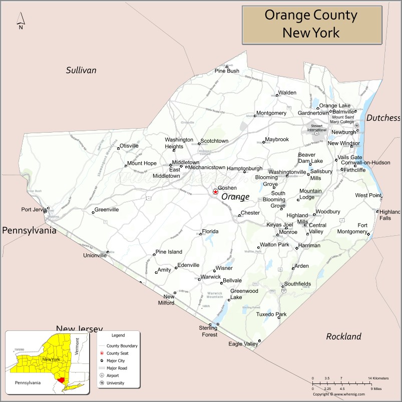
About Orange County Map, New York: The map showing the county boundary, county seat, major cities, highways, water bodies and neighbouring counties.
Related NY Maps & Info
About Orange County, New York
Orange County is a county located in the U.S. state of New York. It's county seat is Goshen. As per 2020 census, the population of Orange County is 404525 people and population density is 482.15 square miles. According to the United States Census Bureau, the county has a total area of 839 sq mi (2,173 km2). Orange County was established on 1683.
Facts about Orange County, New York
| Country | United States |
| State | New York |
| Region | Hudson Valley / Southeastern New York |
| County Seat | Goshen |
| Founded | November 1, 1683 |
| Named For | Prince of Orange (William III of England) |
| Coordinates | 41.40° N, 74.30° W |
| Total Area | 839 sq mi |
| Land Area | 812 sq mi |
| Water Area | 27 sq mi |
| Water % | 3.2% |
| Population (2020) | 384,940+ |
| Estimated Population (2024) | 404,000+ |
| Population Density | 498/sq mi |
| Largest City | Newburgh |
| Other Towns & Communities | Middletown, Wallkill, Warwick, Monroe, Cornwall, Goshen |
| Main Industries | Services, Tourism, Education, Retail, Manufacturing |
| Major Highways | I‑87 (NYS Thruway), I‑84, NY‑17, U.S. 9W |
| Time Zone | Eastern Time (UTC−05:00) |
| Known For | Hudson River Valley scenery, West Point, LEGOLAND® New York, Woodbury Common Premium Outlets |
| Website | https://www.orangecountygov.com/ |
Top Attractions in Orange County, New York
- Storm King Art Center – Large outdoor sculpture park.
- West Point Military Academy – Historic U.S. Army academy.
- Woodbury Common Premium Outlets – Major outlet shopping center.
- Bear Mountain State Park – Hiking and Hudson River views.
- Brotherhood Winery – America’s oldest winery.
- Hudson Highlands Nature Museum – Nature exhibits and trails.
- Storm King Mountain – Scenic hiking destination.
- New Windsor Cantonment – Revolutionary War encampment.
- Harness Racing Museum & Hall of Fame – Horse racing history.
- Black Rock Forest – Research forest and hiking trails.
- Schunnemunk State Park – Rugged trails and views.
- Hudson River Waterfront – Scenic river access and parks.
Cities & Towns in Orange County, New York
Newburgh, Middletown, Port Jervis, Warwick, Goshen, Monroe, Montgomery, Tuxedo Park, Chester, Cornwall, Cornwall-on-Hudson, Highland Falls, Harriman, Blooming Grove, Deerpark, Wallkill, Slate Hill, Florida, Otisville, Pine Bush
- Albany County Map
- Allegany County Map
- Bronx County Map
- Broome County Map
- Cattaraugus County Map
- Cayuga County Map
- Chautauqua County Map
- Chemung County Map
- Chenango County Map
- Clinton County Map
- Columbia County Map
- Cortland County Map
- Delaware County Map
- Dutchess County Map
- Erie County Map
- Essex County Map
- Franklin County Map
- Fulton County Map
- Genesee County Map
- Greene County Map
- Hamilton County Map
- Herkimer County Map
- Jefferson County Map
- Kings County Map
- Lewis County Map
- Livingston County Map
- Madison County Map
- Monroe County Map
- Montgomery County Map
- Nassau County Map
- New York County Map
- Niagara County Map
- Oneida County Map
- Onondaga County Map
- Ontario County Map
- Orange County Map
- Orleans County Map
- Oswego County Map
- Otsego County Map
- Putnam County Map
- Queens County Map
- Rensselaer County Map
- Richmond County Map
- Rockland County Map
- St Lawrence County Map
- Saratoga County Map
- Schenectady County Map
- Schoharie County Map
- Schuyler County Map
- Seneca County Map
- Steuben County Map
- Suffolk County Map
- Sullivan County Map
- Tioga County Map
- Tompkins County Map
- Ulster County Map
- Warren County Map
- Washington County Map
- Wayne County Map
- Westchester County Map
- Wyoming County Map
- Yates County Map
- Alabama Counties
- Alaska boroughs
- Arizona Counties
- Arkansas Counties
- California County Map
- Colorado Counties
- Connecticut Counties
- Delaware Counties
- Florida County Map
- Georgia County Map
- Hawaii Counties
- Idaho Counties
- Illinois Counties
- Indiana Counties
- Iowa Counties
- Kansas Counties
- Kentucky Counties
- Louisiana Counties
- Maine Counties
- Maryland Counties
- Massachusetts Counties
- Michigan County Map
- Minnesota Counties
- Mississippi Counties
- Missouri Counties
- Montana Counties
- Nebraska Counties
- Nevada Counties
- New York Counties
- New Hampshire Counties
- New Jersey Counties
- New Mexico Counties
- North Carolina Counties
- North Dakota Counties
- Ohio County Map
- Oklahoma Counties
- Oregon Counties
- Pennsylvania Counties
- Rhode Island Counties
- South Carolina Counties
- South Dakota Counties
- Map of Tennessee
- Texas County Map
- Utah Counties
- Vermont Counties
- Virginia Counties
- Washington Counties
- West Virginia Counties
- Wisconsin Counties
- Wyoming Counties