Written and Fact-checked by Mukesh Kumar | Updated On: April 256 2026 | 15:50 ET
Map of Erie County - Erie County is a county located in the U.S. state of New York. Erie County Map showing cities, highways, important places and water bodies. Get Where is Erie County located in the map, major cities in Erie county, population, areas, and places of interest.
Map of Erie County, New York
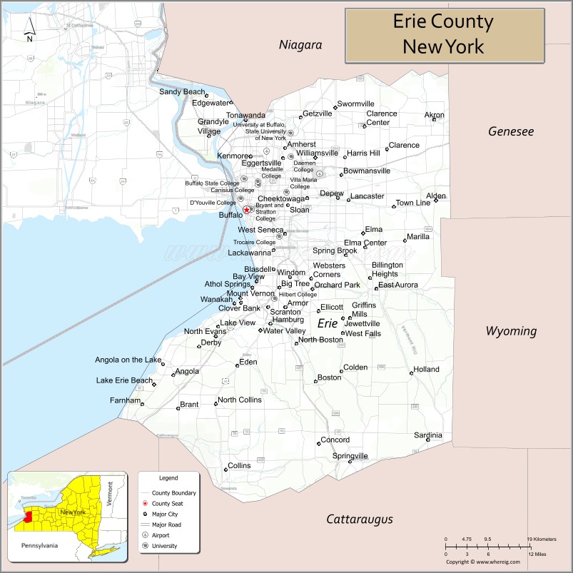
About Erie County Map, New York: The map showing the county boundary, county seat, major cities, highways, water bodies and neighbouring counties.
Related NY Maps & Info
About Erie County, New York
Erie County is a county located in the U.S. state of New York. It's county seat is Buffalo. As per 2020 census, the population of Erie County is 950683 people and population density is 774.8 square miles. According to the United States Census Bureau, the county has a total area of 1,227 sq mi (3,178 km2). Erie County was established on 1821.
Facts about Erie County, New York
| Country | United States |
| State | New York |
| Region | Western New York / Lake Erie region |
| County Seat | Buffalo |
| Founded | April 2, 1821 |
| Named For | Erie tribe of Native Americans and Lake Erie |
| Coordinates | 42.90° N, 78.85° W |
| Total Area | 1,227 sq mi |
| Land Area | 1,043 sq mi |
| Water Area | 184 sq mi |
| Water % | 15% |
| Population (2020) | 954,236 |
| Estimated Population (2024) | 950,000+ |
| Population Density | 915/sq mi |
| Largest City | Buffalo |
| Other Major Communities | Amherst, Cheektowaga, Tonawanda, West Seneca, Lackawanna, Hamburg |
| Main Industries | Manufacturing, Services, Healthcare, Education, Retail |
| Major Highways | I‑90, I‑190, U.S. 20, NY‑5, NY‑33 |
| Time Zone | Eastern Time (UTC−05:00) |
| Known For | Buffalo & Erie attractions, Lake Erie shoreline, professional sports, cultural institutions |
| Website | https://www3.erie.gov/ |
Top Attractions in Erie County, New York
- Buffalo and Erie County Naval & Military Park – Historic naval ships.
- Delaware Park – Frederick Law Olmsted-designed park.
- Buffalo Zoo – One of the nation’s oldest zoos.
- Canalside – Waterfront recreation and events.
- Buffalo and Erie County Botanical Gardens – Historic glass conservatory.
- Darien Lake State Park – Camping and outdoor recreation.
- KeyBank Center – Sports and concert arena.
- Buffalo City Hall – Art Deco landmark.
- Shea’s Performing Arts Center – Historic theater.
- Niagara Falls (nearby) – World-famous waterfalls.
- Outer Harbor – Lake Erie waterfront trails.
- Erie Basin Marina – Lighthouse and lake views.
Cities & Towns in Erie County, New York
Buffalo, Cheektowaga, Amherst, Tonawanda, Lackawanna, West Seneca, Hamburg, Alden, Clarence, Evans, Grand Island, Lancaster, Orchard Park, East Aurora, Gowanda, Depew, Blasdell, Holland, Farnham, Marilla, Elma
- Albany County Map
- Allegany County Map
- Bronx County Map
- Broome County Map
- Cattaraugus County Map
- Cayuga County Map
- Chautauqua County Map
- Chemung County Map
- Chenango County Map
- Clinton County Map
- Columbia County Map
- Cortland County Map
- Delaware County Map
- Dutchess County Map
- Erie County Map
- Essex County Map
- Franklin County Map
- Fulton County Map
- Genesee County Map
- Greene County Map
- Hamilton County Map
- Herkimer County Map
- Jefferson County Map
- Kings County Map
- Lewis County Map
- Livingston County Map
- Madison County Map
- Monroe County Map
- Montgomery County Map
- Nassau County Map
- New York County Map
- Niagara County Map
- Oneida County Map
- Onondaga County Map
- Ontario County Map
- Orange County Map
- Orleans County Map
- Oswego County Map
- Otsego County Map
- Putnam County Map
- Queens County Map
- Rensselaer County Map
- Richmond County Map
- Rockland County Map
- St Lawrence County Map
- Saratoga County Map
- Schenectady County Map
- Schoharie County Map
- Schuyler County Map
- Seneca County Map
- Steuben County Map
- Suffolk County Map
- Sullivan County Map
- Tioga County Map
- Tompkins County Map
- Ulster County Map
- Warren County Map
- Washington County Map
- Wayne County Map
- Westchester County Map
- Wyoming County Map
- Yates County Map
- Alabama Counties
- Alaska boroughs
- Arizona Counties
- Arkansas Counties
- California County Map
- Colorado Counties
- Connecticut Counties
- Delaware Counties
- Florida County Map
- Georgia County Map
- Hawaii Counties
- Idaho Counties
- Illinois Counties
- Indiana Counties
- Iowa Counties
- Kansas Counties
- Kentucky Counties
- Louisiana Counties
- Maine Counties
- Maryland Counties
- Massachusetts Counties
- Michigan County Map
- Minnesota Counties
- Mississippi Counties
- Missouri Counties
- Montana Counties
- Nebraska Counties
- Nevada Counties
- New York Counties
- New Hampshire Counties
- New Jersey Counties
- New Mexico Counties
- North Carolina Counties
- North Dakota Counties
- Ohio County Map
- Oklahoma Counties
- Oregon Counties
- Pennsylvania Counties
- Rhode Island Counties
- South Carolina Counties
- South Dakota Counties
- Map of Tennessee
- Texas County Map
- Utah Counties
- Vermont Counties
- Virginia Counties
- Washington Counties
- West Virginia Counties
- Wisconsin Counties
- Wyoming Counties