Written and Fact-checked by Mukesh Kumar | Updated On: April 256 2026 | 15:50 ET
Map of Lewis County - Lewis County is a county located in the U.S. state of New York. Lewis County Map showing cities, highways, important places and water bodies. Get Where is Lewis County located in the map, major cities in Lewis county, population, areas, and places of interest.
Map of Lewis County, New York
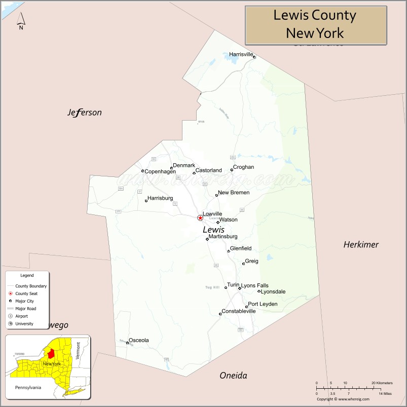
About Lewis County Map, New York: The map showing the county boundary, county seat, major cities, highways, water bodies and neighbouring counties.
Related NY Maps & Info
About Lewis County, New York
Lewis County is a county located in the U.S. state of New York. It's county seat is Lowville. As per 2020 census, the population of Lewis County is 26573 people and population density is 20.6 square miles. According to the United States Census Bureau, the county has a total area of 1,290 sq mi (3,341 km2). Lewis County was established on 1805.
Facts about Lewis County, New York
| Country | United States |
| State | New York |
| Region | North Country / Tug Hill & Adirondack area |
| County Seat | Lowville |
| Founded | March 28, 1805 |
| Named For | Morgan Lewis (Governor of New York) |
| Coordinates | 43.75° N, 75.45° W |
| Total Area | 1,290 sq mi |
| Land Area | 1,275 sq mi |
| Water Area | 15 sq mi |
| Water % | 1.2% |
| Population (2020) | 26,582 |
| Estimated Population (2025) | 26,556 |
| Population Density | 21/sq mi |
| Largest Municipality | Lowville (village) |
| Other Towns & Communities | Croghan, Constableville, Leyden, Lyonsdale, Greig, Denmark, Harrisburg, Watson, West Turin |
| Main Industries | Dairy farming, Maple syrup production, Agriculture, Forestry, Tourism |
| Major Highways | NY‑12, NY‑26, NY‑812, NY‑3 |
| Time Zone | Eastern Time (UTC−05:00) |
| Known For | Black River Valley, Tug Hill snowbelt, Adirondack foothills, rural landscapes & outdoor recreation |
| Website | https://lewiscountyny.gov/ |
Top Attractions in Lewis County, New York
- Tug Hill Plateau – Snowfall region and outdoor recreation.
- Whetstone Gulf State Park – Deep gorge and hiking trails.
- Beaver River – Fishing and paddling river.
- Lowville Cream Cheese Festival – Annual local festival.
- Independence River Wild Forest – Hiking and wilderness area.
- Lewis County Historical Society – Local history museum.
- Brantingham Lake – Boating and lakeside recreation.
- Otter Creek Horse Trails – Scenic horseback riding.
- Lyons Falls Pulp Mill Dam – Scenic waterfall area.
- Moose River Plains (nearby) – Camping and trails.
- Snow Ridge Ski Area – Skiing and winter sports.
- Lowville Downtown Area – Shops and small-town charm.
Cities & Towns in Lewis County, New York
Lowville, Castorland, Lyons Falls, Port Leyden, Croghan, West Leyden, Turin, Lewis, Montague, Turin Center, Harrisville, New Bremen, Denmark, Harrisville Center
- Albany County Map
- Allegany County Map
- Bronx County Map
- Broome County Map
- Cattaraugus County Map
- Cayuga County Map
- Chautauqua County Map
- Chemung County Map
- Chenango County Map
- Clinton County Map
- Columbia County Map
- Cortland County Map
- Delaware County Map
- Dutchess County Map
- Erie County Map
- Essex County Map
- Franklin County Map
- Fulton County Map
- Genesee County Map
- Greene County Map
- Hamilton County Map
- Herkimer County Map
- Jefferson County Map
- Kings County Map
- Lewis County Map
- Livingston County Map
- Madison County Map
- Monroe County Map
- Montgomery County Map
- Nassau County Map
- New York County Map
- Niagara County Map
- Oneida County Map
- Onondaga County Map
- Ontario County Map
- Orange County Map
- Orleans County Map
- Oswego County Map
- Otsego County Map
- Putnam County Map
- Queens County Map
- Rensselaer County Map
- Richmond County Map
- Rockland County Map
- St Lawrence County Map
- Saratoga County Map
- Schenectady County Map
- Schoharie County Map
- Schuyler County Map
- Seneca County Map
- Steuben County Map
- Suffolk County Map
- Sullivan County Map
- Tioga County Map
- Tompkins County Map
- Ulster County Map
- Warren County Map
- Washington County Map
- Wayne County Map
- Westchester County Map
- Wyoming County Map
- Yates County Map
- Alabama Counties
- Alaska boroughs
- Arizona Counties
- Arkansas Counties
- California County Map
- Colorado Counties
- Connecticut Counties
- Delaware Counties
- Florida County Map
- Georgia County Map
- Hawaii Counties
- Idaho Counties
- Illinois Counties
- Indiana Counties
- Iowa Counties
- Kansas Counties
- Kentucky Counties
- Louisiana Counties
- Maine Counties
- Maryland Counties
- Massachusetts Counties
- Michigan County Map
- Minnesota Counties
- Mississippi Counties
- Missouri Counties
- Montana Counties
- Nebraska Counties
- Nevada Counties
- New York Counties
- New Hampshire Counties
- New Jersey Counties
- New Mexico Counties
- North Carolina Counties
- North Dakota Counties
- Ohio County Map
- Oklahoma Counties
- Oregon Counties
- Pennsylvania Counties
- Rhode Island Counties
- South Carolina Counties
- South Dakota Counties
- Map of Tennessee
- Texas County Map
- Utah Counties
- Vermont Counties
- Virginia Counties
- Washington Counties
- West Virginia Counties
- Wisconsin Counties
- Wyoming Counties