Written and Fact-checked by Mukesh Kumar | Updated On: April 256 2026 | 15:50 ET
Map of Queens County - Queens County is a county located in the U.S. state of New York. Queens County Map showing cities, highways, important places and water bodies. Get Where is Queens County located in the map, major cities in Queens county, population, areas, and places of interest.
Map of Queens County, New York
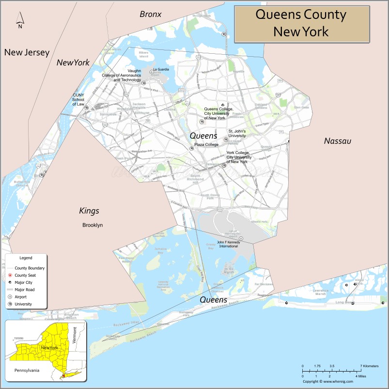
About Queens County Map, New York: The map showing the county boundary, county seat, major cities, highways, water bodies and neighbouring counties.
Related NY Maps & Info
About Queens County, New York
Queens County is a county located in the U.S. state of New York. It's county seat is none (sui generis). As per 2020 census, the population of Queens County is 2331143 people and population density is 13075.74 square miles. According to the United States Census Bureau, the county has a total area of 178.28 sq mi (462 km2). Queens County was established on 1683.
Facts about Queens County, New York
| Country | United States |
| State | New York |
| Region | New York City / Long Island |
| County Seat | Queens (coextensive with borough) |
| Founded | 1683 |
| Named For | Queen Catherine of Braganza, wife of King Charles II |
| Coordinates | 40.75° N, 73.87° W |
| Total Area | 181.5 sq mi |
| Land Area | 108.7 sq mi |
| Water Area | 72.8 sq mi |
| Water % | 40% |
| Population (2020) | 2,405,464 |
| Estimated Population (2023) | 2,252,196 |
| Population Density | 20,700/sq mi (land area) |
| Largest Municipality | Queens (borough of New York City) |
| Other Neighborhoods | Astoria, Flushing, Jamaica, Long Island City, Corona, Bayside, Forest Hills |
| Main Industries | Services, Transportation, Education, Healthcare, Media & Film |
| Major Highways | I‑495, I‑278, Grand Central Parkway, Belt Parkway |
| Time Zone | Eastern Time (UTC−05:00) |
| Known For | John F. Kennedy & LaGuardia Airports, Flushing Meadows–Corona Park, Citi Field, USTA National Tennis Center, cultural diversity |
| Website | https://www.nyc.gov/boroughs/queens |
Top Attractions in Queens County, New York
- Flushing Meadows–Corona Park – Large park and landmarks.
- Unisphere – Iconic World’s Fair globe.
- Citi Field – Home of the New York Mets.
- USTA Billie Jean King National Tennis Center – US Open tennis venue.
- Queens Museum – Art and NYC history exhibits.
- MoMA PS1 – Contemporary art museum.
- Astoria Park – River views and recreation.
- Museum of the Moving Image – Film and media history.
- Gantry Plaza State Park – Manhattan skyline views.
- Rockaway Beach – Ocean beach and boardwalk.
- Socrates Sculpture Park – Outdoor art installations.
- Queens Botanical Garden – Gardens and walking paths.
Cities & Towns in Queens County, New York
Queens, Flushing, Astoria, Long Island City, Jamaica, Forest Hills, Kew Gardens, Bayside, Whitestone, Rego Park, Ridgewood, Woodside, Sunnyside, Jackson Heights, Corona, Howard Beach, Rockaway, Ozone Park, Far Rockaway, Richmond Hill
- Albany County Map
- Allegany County Map
- Bronx County Map
- Broome County Map
- Cattaraugus County Map
- Cayuga County Map
- Chautauqua County Map
- Chemung County Map
- Chenango County Map
- Clinton County Map
- Columbia County Map
- Cortland County Map
- Delaware County Map
- Dutchess County Map
- Erie County Map
- Essex County Map
- Franklin County Map
- Fulton County Map
- Genesee County Map
- Greene County Map
- Hamilton County Map
- Herkimer County Map
- Jefferson County Map
- Kings County Map
- Lewis County Map
- Livingston County Map
- Madison County Map
- Monroe County Map
- Montgomery County Map
- Nassau County Map
- New York County Map
- Niagara County Map
- Oneida County Map
- Onondaga County Map
- Ontario County Map
- Orange County Map
- Orleans County Map
- Oswego County Map
- Otsego County Map
- Putnam County Map
- Queens County Map
- Rensselaer County Map
- Richmond County Map
- Rockland County Map
- St Lawrence County Map
- Saratoga County Map
- Schenectady County Map
- Schoharie County Map
- Schuyler County Map
- Seneca County Map
- Steuben County Map
- Suffolk County Map
- Sullivan County Map
- Tioga County Map
- Tompkins County Map
- Ulster County Map
- Warren County Map
- Washington County Map
- Wayne County Map
- Westchester County Map
- Wyoming County Map
- Yates County Map
- Alabama Counties
- Alaska boroughs
- Arizona Counties
- Arkansas Counties
- California County Map
- Colorado Counties
- Connecticut Counties
- Delaware Counties
- Florida County Map
- Georgia County Map
- Hawaii Counties
- Idaho Counties
- Illinois Counties
- Indiana Counties
- Iowa Counties
- Kansas Counties
- Kentucky Counties
- Louisiana Counties
- Maine Counties
- Maryland Counties
- Massachusetts Counties
- Michigan County Map
- Minnesota Counties
- Mississippi Counties
- Missouri Counties
- Montana Counties
- Nebraska Counties
- Nevada Counties
- New York Counties
- New Hampshire Counties
- New Jersey Counties
- New Mexico Counties
- North Carolina Counties
- North Dakota Counties
- Ohio County Map
- Oklahoma Counties
- Oregon Counties
- Pennsylvania Counties
- Rhode Island Counties
- South Carolina Counties
- South Dakota Counties
- Map of Tennessee
- Texas County Map
- Utah Counties
- Vermont Counties
- Virginia Counties
- Washington Counties
- West Virginia Counties
- Wisconsin Counties
- Wyoming Counties