Written and Fact-checked by Mukesh Kumar | Updated On: April 256 2026 | 15:50 ET
Map of Onondaga County - Onondaga County is a county located in the U.S. state of New York. Onondaga County Map showing cities, highways, important places and water bodies. Get Where is Onondaga County located in the map, major cities in Onondaga county, population, areas, and places of interest.
Map of Onondaga County, New York
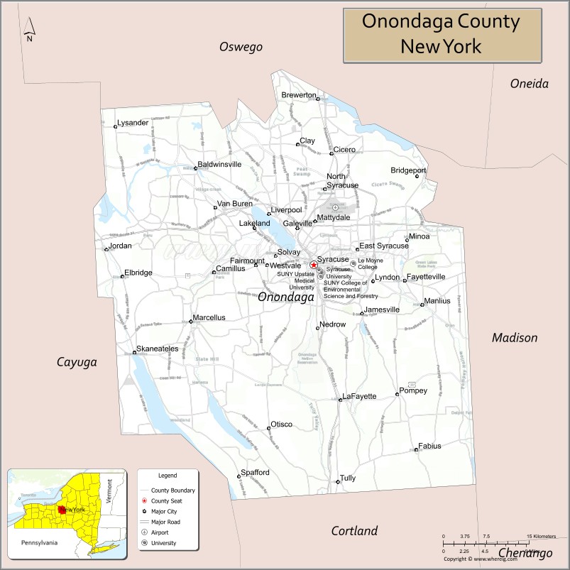
About Onondaga County Map, New York: The map showing the county boundary, county seat, major cities, highways, water bodies and neighbouring counties.
Related NY Maps & Info
About Onondaga County, New York
Onondaga County is a county located in the U.S. state of New York. It's county seat is Syracuse. As per 2020 census, the population of Onondaga County is 473236 people and population density is 587.14 square miles. According to the United States Census Bureau, the county has a total area of 806 sq mi (2,088 km2). Onondaga County was established on 1792.
Facts about Onondaga County, New York
| Country | United States |
| State | New York |
| Region | Central New York / Mohawk Valley area |
| County Seat | Syracuse |
| Founded | 1794 |
| Named For | Onondaga people (Iroquois Confederacy tribe) |
| Coordinates | 43.05° N, 75.99° W |
| Total Area | 806 sq mi |
| Land Area | 778 sq mi |
| Water Area | 27 sq mi |
| Water % | 3.4% |
| Population (2020) | 476,516 |
| Estimated Population (2024) | 467,873 |
| Population Density | 600/sq mi |
| Largest City | Syracuse |
| Other Towns & Communities | Clay, Cicero, Manlius, Salina, DeWitt, Lysander, Baldwinsville, Skaneateles, Tully, Spafford |
| Main Industries | Services, Education, Healthcare, Manufacturing, Retail |
| Major Highways | I‑81, I‑90 (NYS Thruway), NY‑5, NY‑11, NY‑31 |
| Time Zone | Eastern Time (UTC−05:00) |
| Known For | Syracuse University, Onondaga Lake, Erie Canal heritage, Finger Lakes proximity |
| Website | https://www.ongov.net/ |
Top Attractions in Onondaga County, New York
- Destiny USA – Large shopping and entertainment complex.
- Onondaga Lake Park – Waterfront trails and recreation.
- Erie Canal Museum – Canal history exhibits.
- Rosamond Gifford Zoo – Wildlife exhibits and conservation.
- Everson Museum of Art – Modern and contemporary art.
- Clinton Square – Downtown events and gatherings.
- Green Lakes State Park – Unique glacial lakes.
- Salt Museum – Syracuse salt industry history.
- Burnet Park Zoo (historic) – Former zoo park area.
- Carrier Dome (JMA Wireless Dome) – Sports and events venue.
- Skä•noñh–Great Law of Peace Center – Haudenosaunee culture center.
- Oakwood Cemetery – Historic burial ground.
Cities & Towns in Onondaga County, New York
Syracuse, Camillus, Dewitt, Manlius, Salina, Cicero, Lysander, Geddes, Onondaga, Fabius, Tully, Spafford, Skaneateles, Marcellus, Otisco, LaFayette, Jordan, Elbridge, Baldwinsville, Clay
- Albany County Map
- Allegany County Map
- Bronx County Map
- Broome County Map
- Cattaraugus County Map
- Cayuga County Map
- Chautauqua County Map
- Chemung County Map
- Chenango County Map
- Clinton County Map
- Columbia County Map
- Cortland County Map
- Delaware County Map
- Dutchess County Map
- Erie County Map
- Essex County Map
- Franklin County Map
- Fulton County Map
- Genesee County Map
- Greene County Map
- Hamilton County Map
- Herkimer County Map
- Jefferson County Map
- Kings County Map
- Lewis County Map
- Livingston County Map
- Madison County Map
- Monroe County Map
- Montgomery County Map
- Nassau County Map
- New York County Map
- Niagara County Map
- Oneida County Map
- Onondaga County Map
- Ontario County Map
- Orange County Map
- Orleans County Map
- Oswego County Map
- Otsego County Map
- Putnam County Map
- Queens County Map
- Rensselaer County Map
- Richmond County Map
- Rockland County Map
- St Lawrence County Map
- Saratoga County Map
- Schenectady County Map
- Schoharie County Map
- Schuyler County Map
- Seneca County Map
- Steuben County Map
- Suffolk County Map
- Sullivan County Map
- Tioga County Map
- Tompkins County Map
- Ulster County Map
- Warren County Map
- Washington County Map
- Wayne County Map
- Westchester County Map
- Wyoming County Map
- Yates County Map
- Alabama Counties
- Alaska boroughs
- Arizona Counties
- Arkansas Counties
- California County Map
- Colorado Counties
- Connecticut Counties
- Delaware Counties
- Florida County Map
- Georgia County Map
- Hawaii Counties
- Idaho Counties
- Illinois Counties
- Indiana Counties
- Iowa Counties
- Kansas Counties
- Kentucky Counties
- Louisiana Counties
- Maine Counties
- Maryland Counties
- Massachusetts Counties
- Michigan County Map
- Minnesota Counties
- Mississippi Counties
- Missouri Counties
- Montana Counties
- Nebraska Counties
- Nevada Counties
- New York Counties
- New Hampshire Counties
- New Jersey Counties
- New Mexico Counties
- North Carolina Counties
- North Dakota Counties
- Ohio County Map
- Oklahoma Counties
- Oregon Counties
- Pennsylvania Counties
- Rhode Island Counties
- South Carolina Counties
- South Dakota Counties
- Map of Tennessee
- Texas County Map
- Utah Counties
- Vermont Counties
- Virginia Counties
- Washington Counties
- West Virginia Counties
- Wisconsin Counties
- Wyoming Counties