Written and Fact-checked by Mukesh Kumar | Updated On: April 256 2026 | 15:50 ET
Map of Hamilton County - Hamilton County is a county located in the U.S. state of New York. Hamilton County Map showing cities, highways, important places and water bodies. Get Where is Hamilton County located in the map, major cities in Hamilton county, population, areas, and places of interest.
Map of Hamilton County, New York
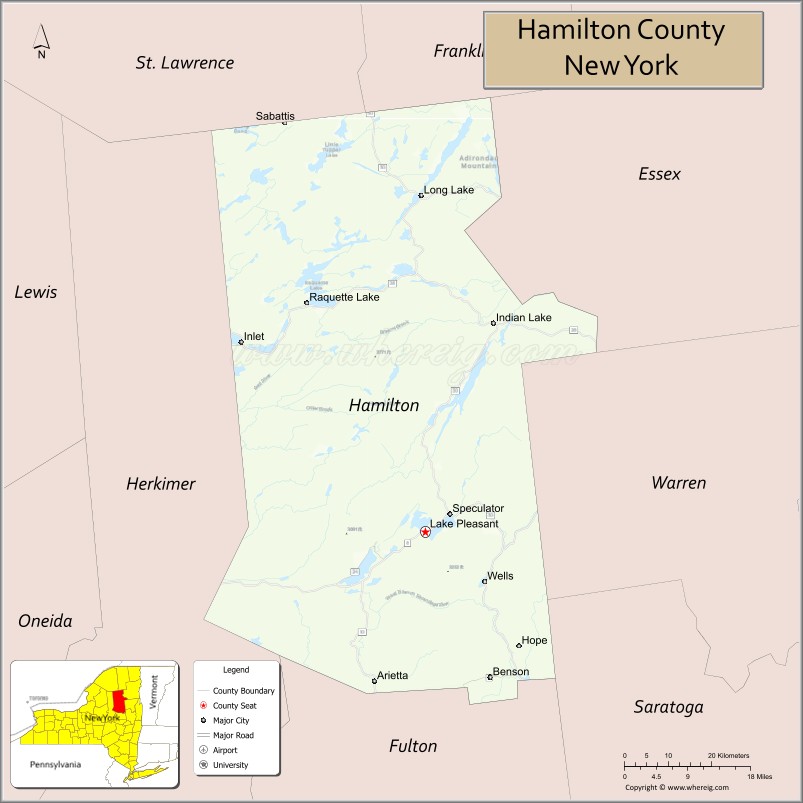
About Hamilton County Map, New York: The map showing the county boundary, county seat, major cities, highways, water bodies and neighbouring counties.
Related NY Maps & Info
About Hamilton County, New York
Hamilton County is a county located in the U.S. state of New York. It's county seat is Lake Pleasant. As per 2020 census, the population of Hamilton County is 5119 people and population density is 2.83 square miles. According to the United States Census Bureau, the county has a total area of 1,808 sq mi (4,683 km2). Hamilton County was established on 1816.
Facts about Hamilton County, New York
| Country | United States |
| State | New York |
| Region | Northern New York / Adirondack Park |
| County Seat | Lake Pleasant |
| Founded | April 12, 1816 |
| Named For | Alexander Hamilton (first U.S. Secretary of the Treasury) |
| Coordinates | 43.67° N, 74.50° W |
| Total Area | 1,808 sq mi |
| Land Area | 1,717 sq mi |
| Water Area | 90 sq mi |
| Water % | 5% |
| Population (2020) | 4,500‑5,100 |
| Estimated Population (2025) | 5,094 |
| Population Density | 3/sq mi |
| Largest Communities | Indian Lake, Long Lake, Speculator |
| Other Towns | Lake Pleasant, Wells, Blue Mountain Lake |
| Main Industries | Tourism, Outdoor recreation, Services |
| Major Highways | NY‑8, NY‑28, NY‑30 |
| Time Zone | Eastern Time (UTC−05:00) |
| Known For | Adirondack wilderness, lakes & mountains, sparse population |
| Website | https://www.hamiltoncounty.com/ |
Top Attractions in Hamilton County, New York
- Adirondack Mountains – Wilderness hiking and scenery.
- Indian Lake – Boating, fishing, and lake views.
- Blue Mountain Lake – Scenic lake and recreation.
- Adirondack Experience – Regional history museum.
- Blue Mountain – Hiking and summit views.
- Lake Pleasant – Village lake and recreation.
- Speculator Village – Small-town shops and dining.
- Sacandaga River – Fishing and paddling.
- Hamilton County Historical Museum – Local heritage exhibits.
- Lewey Lake Campground – Camping and swimming.
- Jessup River Wild Forest – Trails and wildlife.
- Pillsbury Mountain Fire Tower – Panoramic Adirondack views.
Cities & Towns in Hamilton County, New York
Lake Pleasant, Indian Lake, Long Lake, Inlet, Hope, Wells, Speculator, Piseco, Sacandaga Park, Raquette Lake, Blue Mountain Lake, Newcomb
- Albany County Map
- Allegany County Map
- Bronx County Map
- Broome County Map
- Cattaraugus County Map
- Cayuga County Map
- Chautauqua County Map
- Chemung County Map
- Chenango County Map
- Clinton County Map
- Columbia County Map
- Cortland County Map
- Delaware County Map
- Dutchess County Map
- Erie County Map
- Essex County Map
- Franklin County Map
- Fulton County Map
- Genesee County Map
- Greene County Map
- Hamilton County Map
- Herkimer County Map
- Jefferson County Map
- Kings County Map
- Lewis County Map
- Livingston County Map
- Madison County Map
- Monroe County Map
- Montgomery County Map
- Nassau County Map
- New York County Map
- Niagara County Map
- Oneida County Map
- Onondaga County Map
- Ontario County Map
- Orange County Map
- Orleans County Map
- Oswego County Map
- Otsego County Map
- Putnam County Map
- Queens County Map
- Rensselaer County Map
- Richmond County Map
- Rockland County Map
- St Lawrence County Map
- Saratoga County Map
- Schenectady County Map
- Schoharie County Map
- Schuyler County Map
- Seneca County Map
- Steuben County Map
- Suffolk County Map
- Sullivan County Map
- Tioga County Map
- Tompkins County Map
- Ulster County Map
- Warren County Map
- Washington County Map
- Wayne County Map
- Westchester County Map
- Wyoming County Map
- Yates County Map
- Alabama Counties
- Alaska boroughs
- Arizona Counties
- Arkansas Counties
- California County Map
- Colorado Counties
- Connecticut Counties
- Delaware Counties
- Florida County Map
- Georgia County Map
- Hawaii Counties
- Idaho Counties
- Illinois Counties
- Indiana Counties
- Iowa Counties
- Kansas Counties
- Kentucky Counties
- Louisiana Counties
- Maine Counties
- Maryland Counties
- Massachusetts Counties
- Michigan County Map
- Minnesota Counties
- Mississippi Counties
- Missouri Counties
- Montana Counties
- Nebraska Counties
- Nevada Counties
- New York Counties
- New Hampshire Counties
- New Jersey Counties
- New Mexico Counties
- North Carolina Counties
- North Dakota Counties
- Ohio County Map
- Oklahoma Counties
- Oregon Counties
- Pennsylvania Counties
- Rhode Island Counties
- South Carolina Counties
- South Dakota Counties
- Map of Tennessee
- Texas County Map
- Utah Counties
- Vermont Counties
- Virginia Counties
- Washington Counties
- West Virginia Counties
- Wisconsin Counties
- Wyoming Counties