Written and Fact-checked by Mukesh Kumar | Updated On: April 256 2026 | 15:50 ET
Map of Warren County - Warren County is a county located in the U.S. state of New York. Warren County Map showing cities, highways, important places and water bodies. Get Where is Warren County located in the map, major cities in Warren county, population, areas, and places of interest.
Map of Warren County, New York
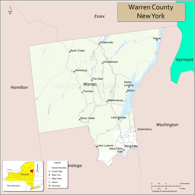
About Warren County Map, New York: The map showing the county boundary, county seat, major cities, highways, water bodies and neighbouring counties.
Related NY Maps & Info
About Warren County, New York
Warren County is a county located in the U.S. state of New York. It's county seat is Queensbury. As per 2020 census, the population of Warren County is 65618 people and population density is 75.42 square miles. According to the United States Census Bureau, the county has a total area of 870 sq mi (2,253 km2). Warren County was established on 1813.
Facts about Warren County, New York
| Country | United States |
| State | New York |
| Region | Capital District / Adirondack Mountains |
| County Seat | Queensbury |
| Founded | 1813 |
| Named For | General Joseph Warren (Revolutionary War hero) |
| Coordinates | 43.56° N, 73.84° W |
| Total Area | 932 sq mi |
| Land Area | 866 sq mi |
| Water Area | 66 sq mi |
| Water % | 7.1% |
| Population (2020) | 65,737 |
| Estimated Population (2024) | 66,000+ |
| Population Density | 76/sq mi |
| Largest Municipality | Queensbury (town) |
| Other Major Communities | Glens Falls, Lake George (village), Warrensburg, Lake Luzerne, Johnsburg, Bolton |
| Main Industries | Tourism (Lake George & Adirondacks), Manufacturing, Services, Healthcare |
| Major Highways | I‑87 (Northway), U.S. 9, NY‑9N, NY‑28 |
| Time Zone | Eastern Time (UTC−05:00) |
| Known For | Lake George & Adirondack scenery, Fort William Henry, outdoor recreation |
| Website | https://www.warrencountyny.gov/ |
Top Attractions in Warren County, New York
- Lake George – Boating, beaches, and lake views.
- Lake George Village – Shops, dining, and waterfront.
- Fort William Henry Museum – French and Indian War history.
- Prospect Mountain – Scenic summit views.
- Six Flags Great Escape – Amusement park and rides.
- Adirondack Extreme Adventure Course – Aerial ropes and zip lines.
- West Mountain – Skiing and outdoor recreation.
- Million Dollar Beach – Popular Lake George beach.
- Crandall Park – Large city park and trails.
- Warrensburg Museum of Local History – Regional history exhibits.
- Hudson River – Paddling and scenic river views.
- Pack Demonstration Forest – Forest trails and nature study.
Cities & Towns in Warren County, New York
Lake George, Glens Falls, Queensbury, Warrensburg, Bolton, Chestertown, Thurman, Hague, Stony Creek, Johnsburg, Horicon, Lake Luzerne, Bolton Landing, Diamond Point, Chestertown Center
- Albany County Map
- Allegany County Map
- Bronx County Map
- Broome County Map
- Cattaraugus County Map
- Cayuga County Map
- Chautauqua County Map
- Chemung County Map
- Chenango County Map
- Clinton County Map
- Columbia County Map
- Cortland County Map
- Delaware County Map
- Dutchess County Map
- Erie County Map
- Essex County Map
- Franklin County Map
- Fulton County Map
- Genesee County Map
- Greene County Map
- Hamilton County Map
- Herkimer County Map
- Jefferson County Map
- Kings County Map
- Lewis County Map
- Livingston County Map
- Madison County Map
- Monroe County Map
- Montgomery County Map
- Nassau County Map
- New York County Map
- Niagara County Map
- Oneida County Map
- Onondaga County Map
- Ontario County Map
- Orange County Map
- Orleans County Map
- Oswego County Map
- Otsego County Map
- Putnam County Map
- Queens County Map
- Rensselaer County Map
- Richmond County Map
- Rockland County Map
- St Lawrence County Map
- Saratoga County Map
- Schenectady County Map
- Schoharie County Map
- Schuyler County Map
- Seneca County Map
- Steuben County Map
- Suffolk County Map
- Sullivan County Map
- Tioga County Map
- Tompkins County Map
- Ulster County Map
- Warren County Map
- Washington County Map
- Wayne County Map
- Westchester County Map
- Wyoming County Map
- Yates County Map
- Alabama Counties
- Alaska boroughs
- Arizona Counties
- Arkansas Counties
- California County Map
- Colorado Counties
- Connecticut Counties
- Delaware Counties
- Florida County Map
- Georgia County Map
- Hawaii Counties
- Idaho Counties
- Illinois Counties
- Indiana Counties
- Iowa Counties
- Kansas Counties
- Kentucky Counties
- Louisiana Counties
- Maine Counties
- Maryland Counties
- Massachusetts Counties
- Michigan County Map
- Minnesota Counties
- Mississippi Counties
- Missouri Counties
- Montana Counties
- Nebraska Counties
- Nevada Counties
- New York Counties
- New Hampshire Counties
- New Jersey Counties
- New Mexico Counties
- North Carolina Counties
- North Dakota Counties
- Ohio County Map
- Oklahoma Counties
- Oregon Counties
- Pennsylvania Counties
- Rhode Island Counties
- South Carolina Counties
- South Dakota Counties
- Map of Tennessee
- Texas County Map
- Utah Counties
- Vermont Counties
- Virginia Counties
- Washington Counties
- West Virginia Counties
- Wisconsin Counties
- Wyoming Counties