Written and Fact-checked by Mukesh Kumar | Updated On: April 256 2026 | 15:50 ET
Map of Chemung County - Chemung County is a county located in the U.S. state of New York. Chemung County Map showing cities, highways, important places and water bodies. Get Where is Chemung County located in the map, major cities in Chemung county, population, areas, and places of interest.
Map of Chemung County, New York
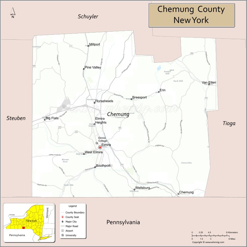
About Chemung County Map, New York: The map showing the county boundary, county seat, major cities, highways, water bodies and neighbouring counties.
Related NY Maps & Info
About Chemung County, New York
Chemung County is a county located in the U.S. state of New York. It's county seat is Elmira. As per 2020 census, the population of Chemung County is 83045 people and population density is 202.15 square miles. According to the United States Census Bureau, the county has a total area of 410.81 sq mi (1,064 km2). Chemung County was established on 1836.
Facts about Chemung County, New York
| Country | United States |
| State | New York |
| Region | Southern Tier / Finger Lakes region |
| County Seat | Elmira |
| Founded | March 29, 1836 |
| Named For | Native American village name meaning “big horn” (Unami/Delaware) |
| Coordinates | 42.14° N, 76.76° W |
| Total Area | 411 sq mi |
| Land Area | 407 sq mi |
| Water Area | 3.4 sq mi |
| Water % | 0.8% |
| Population (2020) | 84,148 |
| Estimated Population (2025) | 80,951 |
| Population Density | 199/sq mi |
| Largest City | Elmira |
| Other Cities & Towns | Horseheads, Big Flats, Southport, Elmira Heights, Wellsburg |
| Main Industries | Services, Manufacturing, Retail, Education |
| Major Highways | I‑86/NY‑17, NY‑13, NY‑14, NY‑34, NY‑223, NY‑328 |
| Time Zone | Eastern Time (UTC−05:00) |
| Known For | “Mark Twain Country” (Twain wrote extensively here), Southern Tier landscapes, Elmira attractions |
| Website | https://www.chemungcountyny.gov/ |
Top Attractions in Chemung County, New York
- Corning Museum of Glass – World-renowned glass museum.
- Rockwell Museum – American art and Western works.
- Eldridge Park – Historic amusement park.
- Mark Twain Study – Author’s writing retreat site.
- National Soaring Museum – Gliding and aviation history.
- Harris Hill Soaring Corporation – Glider flights and views.
- Clemens Center – Performing arts venue.
- Erwin Hollow State Forest – Forest trails and scenery.
- Elmira College Campus – Historic college grounds.
- Woodlawn Cemetery – Mark Twain family burial site.
- First Arena – Sports and concert arena.
- Newtown Battlefield State Park – Revolutionary War site.
Cities & Towns in Chemung County, New York
Elmira, Horseheads, Southport, Big Flats, Chemung, Van Etten, Erin, Ashland, Baldwin, Catlin, Veteran, Wellsburg, Lowman
- Albany County Map
- Allegany County Map
- Bronx County Map
- Broome County Map
- Cattaraugus County Map
- Cayuga County Map
- Chautauqua County Map
- Chemung County Map
- Chenango County Map
- Clinton County Map
- Columbia County Map
- Cortland County Map
- Delaware County Map
- Dutchess County Map
- Erie County Map
- Essex County Map
- Franklin County Map
- Fulton County Map
- Genesee County Map
- Greene County Map
- Hamilton County Map
- Herkimer County Map
- Jefferson County Map
- Kings County Map
- Lewis County Map
- Livingston County Map
- Madison County Map
- Monroe County Map
- Montgomery County Map
- Nassau County Map
- New York County Map
- Niagara County Map
- Oneida County Map
- Onondaga County Map
- Ontario County Map
- Orange County Map
- Orleans County Map
- Oswego County Map
- Otsego County Map
- Putnam County Map
- Queens County Map
- Rensselaer County Map
- Richmond County Map
- Rockland County Map
- St Lawrence County Map
- Saratoga County Map
- Schenectady County Map
- Schoharie County Map
- Schuyler County Map
- Seneca County Map
- Steuben County Map
- Suffolk County Map
- Sullivan County Map
- Tioga County Map
- Tompkins County Map
- Ulster County Map
- Warren County Map
- Washington County Map
- Wayne County Map
- Westchester County Map
- Wyoming County Map
- Yates County Map
- Alabama Counties
- Alaska boroughs
- Arizona Counties
- Arkansas Counties
- California County Map
- Colorado Counties
- Connecticut Counties
- Delaware Counties
- Florida County Map
- Georgia County Map
- Hawaii Counties
- Idaho Counties
- Illinois Counties
- Indiana Counties
- Iowa Counties
- Kansas Counties
- Kentucky Counties
- Louisiana Counties
- Maine Counties
- Maryland Counties
- Massachusetts Counties
- Michigan County Map
- Minnesota Counties
- Mississippi Counties
- Missouri Counties
- Montana Counties
- Nebraska Counties
- Nevada Counties
- New York Counties
- New Hampshire Counties
- New Jersey Counties
- New Mexico Counties
- North Carolina Counties
- North Dakota Counties
- Ohio County Map
- Oklahoma Counties
- Oregon Counties
- Pennsylvania Counties
- Rhode Island Counties
- South Carolina Counties
- South Dakota Counties
- Map of Tennessee
- Texas County Map
- Utah Counties
- Vermont Counties
- Virginia Counties
- Washington Counties
- West Virginia Counties
- Wisconsin Counties
- Wyoming Counties