Written and Fact-checked by Mukesh Kumar | Updated On: April 256 2026 | 15:50 ET
Map of Cortland County - Cortland County is a county located in the U.S. state of New York. Cortland County Map showing cities, highways, important places and water bodies. Get Where is Cortland County located in the map, major cities in Cortland county, population, areas, and places of interest.
Map of Cortland County, New York
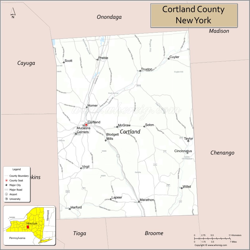
About Cortland County Map, New York: The map showing the county boundary, county seat, major cities, highways, water bodies and neighbouring counties.
Related NY Maps & Info
About Cortland County, New York
Cortland County is a county located in the U.S. state of New York. It's county seat is Cortland. As per 2020 census, the population of Cortland County is 46311 people and population density is 92.25 square miles. According to the United States Census Bureau, the county has a total area of 502 sq mi (1,300 km2). Cortland County was established on 1808.
Facts about Cortland County, New York
| Country | United States |
| State | New York |
| Region | Central New York / Southern Tier |
| County Seat | Cortland |
| Founded | April 8, 1808 |
| Named For | Pierre Van Cortlandt (first lieutenant governor of New York) |
| Coordinates | 42.59° N, 76.18° W |
| Total Area | 502 sq mi |
| Land Area | 499 sq mi |
| Water Area | 2.8 sq mi |
| Water % | 0.5% |
| Population (2020) | 46,809 |
| Estimated Population (2024) | 46,800+ |
| Population Density | 94/sq mi |
| Largest City | Cortland |
| Other Communities | Cortlandville (town), Homer, Cincinnatus, Marathon, Preble, Virgil, Willet |
| Main Industries | Education, Manufacturing, Services, Agriculture |
| Major Highways | I‑81, U.S. 11, NY‑13, NY‑41 |
| Time Zone | Eastern Time (UTC−05:00) |
| Known For | Cortland apple, SUNY Cortland, rural landscapes, regional history |
| Website | https://www.cortlandcountyny.gov/ |
Top Attractions in Cortland County, New York
- Greek Peak Mountain Resort – Skiing and year-round activities.
- Lime Hollow Nature Center – Nature trails and wildlife.
- Cortland County Historical Society – Local history exhibits.
- Otter Creek Horse Trails – Scenic horseback riding trails.
- Homer Village Historic District – Historic homes and streets.
- Skaneateles Lake (nearby) – Scenic Finger Lakes views.
- Glen Haven Farm – Historic farmstead museum.
- Cortland Repertory Theatre – Live theater performances.
- Yaman Park – Riverfront park and walking paths.
- McGraw Falls – Small scenic waterfall.
- Hollenbeck’s Cider Mill – Seasonal cider and donuts.
- SUNY Cortland Campus – Historic college grounds.
Cities & Towns in Cortland County, New York
Cortland, Homer, Cortlandville, Marathon, McGraw, Preble, Truxton, Cincinnatus, Virgil, Taylor, Freetown, Scott, Solon, Lapeer, Harford, Homer Center
- Albany County Map
- Allegany County Map
- Bronx County Map
- Broome County Map
- Cattaraugus County Map
- Cayuga County Map
- Chautauqua County Map
- Chemung County Map
- Chenango County Map
- Clinton County Map
- Columbia County Map
- Cortland County Map
- Delaware County Map
- Dutchess County Map
- Erie County Map
- Essex County Map
- Franklin County Map
- Fulton County Map
- Genesee County Map
- Greene County Map
- Hamilton County Map
- Herkimer County Map
- Jefferson County Map
- Kings County Map
- Lewis County Map
- Livingston County Map
- Madison County Map
- Monroe County Map
- Montgomery County Map
- Nassau County Map
- New York County Map
- Niagara County Map
- Oneida County Map
- Onondaga County Map
- Ontario County Map
- Orange County Map
- Orleans County Map
- Oswego County Map
- Otsego County Map
- Putnam County Map
- Queens County Map
- Rensselaer County Map
- Richmond County Map
- Rockland County Map
- St Lawrence County Map
- Saratoga County Map
- Schenectady County Map
- Schoharie County Map
- Schuyler County Map
- Seneca County Map
- Steuben County Map
- Suffolk County Map
- Sullivan County Map
- Tioga County Map
- Tompkins County Map
- Ulster County Map
- Warren County Map
- Washington County Map
- Wayne County Map
- Westchester County Map
- Wyoming County Map
- Yates County Map
- Alabama Counties
- Alaska boroughs
- Arizona Counties
- Arkansas Counties
- California County Map
- Colorado Counties
- Connecticut Counties
- Delaware Counties
- Florida County Map
- Georgia County Map
- Hawaii Counties
- Idaho Counties
- Illinois Counties
- Indiana Counties
- Iowa Counties
- Kansas Counties
- Kentucky Counties
- Louisiana Counties
- Maine Counties
- Maryland Counties
- Massachusetts Counties
- Michigan County Map
- Minnesota Counties
- Mississippi Counties
- Missouri Counties
- Montana Counties
- Nebraska Counties
- Nevada Counties
- New York Counties
- New Hampshire Counties
- New Jersey Counties
- New Mexico Counties
- North Carolina Counties
- North Dakota Counties
- Ohio County Map
- Oklahoma Counties
- Oregon Counties
- Pennsylvania Counties
- Rhode Island Counties
- South Carolina Counties
- South Dakota Counties
- Map of Tennessee
- Texas County Map
- Utah Counties
- Vermont Counties
- Virginia Counties
- Washington Counties
- West Virginia Counties
- Wisconsin Counties
- Wyoming Counties