Written and Fact-checked by Mukesh Kumar | Updated On: April 256 2026 | 15:50 ET
Map of Albany County - Albany County is a county located in the U.S. state of New York. Albany County Map showing cities, highways, important places and water bodies. Get Where is Albany County located in the map, major cities in Albany county, population, areas, and places of interest.
Map of Albany County, New York
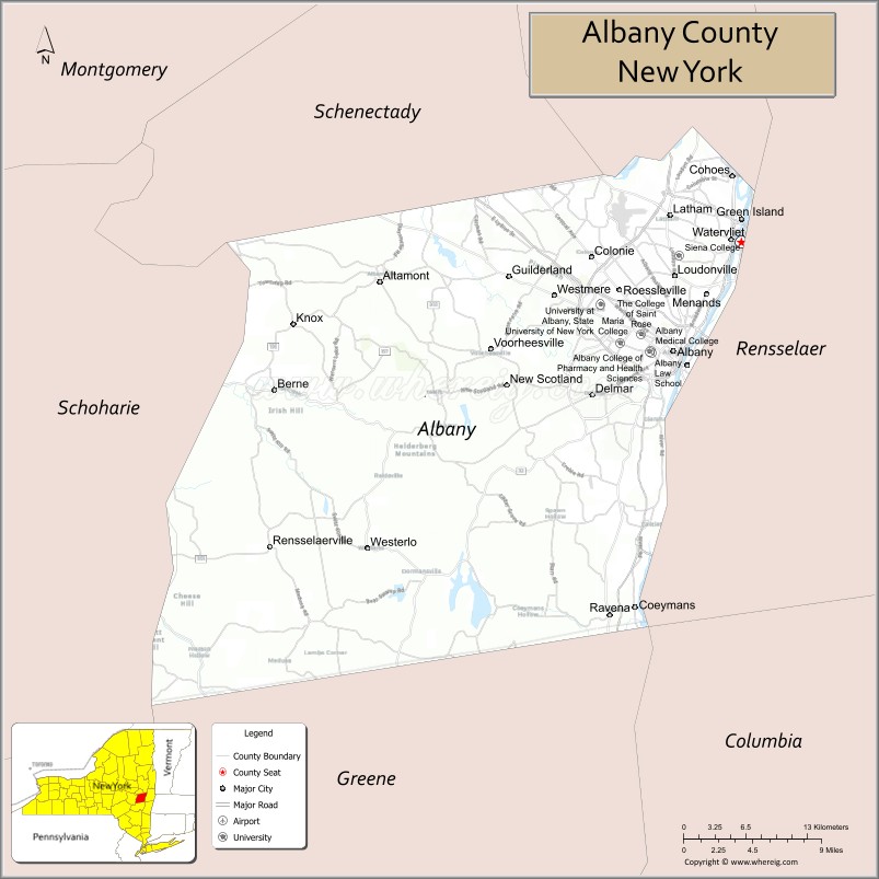
About Albany County Map, New York: The map showing the county boundary, county seat, major cities, highways, water bodies and neighbouring counties.
Related NY Maps & Info
About Albany County, New York
Albany County is a county located in the U.S. state of New York. It's county seat is Albany. As per 2020 census, the population of Albany County is 313743 people and population density is 588.64 square miles. According to the United States Census Bureau, the county has a total area of 533 sq mi (1,380 km2). Albany County was established on 1683.
Facts about Albany County, New York
| Country | United States |
| State | New York |
| Region | Capital District (Eastern New York) |
| County Seat | Albany |
| Founded | November 1, 1683 |
| Named For | James, Duke of York and Albany |
| Coordinates | 42.65° N, 73.75° W |
| Total Area | 533 sq mi |
| Land Area | 523 sq mi |
| Water Area | 10 sq mi |
| Water % | 1.9% |
| Population (2020) | 314,848 |
| Estimated Population (2023) | 315,000+ |
| Population Density | 602/sq mi |
| Largest City | Albany (state capital) |
| Other Cities & Towns | Cohoes, Watervliet, Green Island, Colonie, Guilderland, Bethlehem |
| Main Industries | Government, Education, Healthcare, Technology, Services |
| Major Highways | I‑87, I‑90, U.S. 9, U.S. 20, NY‑5, NY‑85 |
| Time Zone | Eastern Time (UTC−05:00) |
| Known For | New York State Capital, Hudson & Mohawk Rivers, historic sites, parks (e.g., John Boyd Thacher State Park) |
| Website | https://www.albanycountyny.gov/ |
Top Attractions in Albany County, New York
- New York State Capitol – Historic government building with tours.
- Empire State Plaza – Modern complex with museums and art.
- Albany Institute of History & Art – Art and regional history museum.
- The Egg – Performing arts and concert venue.
- Washington Park – Large urban park and events site.
- USS Slater – Restored World War II destroyer escort.
- New York State Museum – State history, science, and culture exhibits.
- Albany Pine Bush Preserve – Nature trails and rare ecosystem.
- Schuyler Mansion – Historic Revolutionary War-era home.
- Albany City Hall – Landmark Romanesque-style building.
- Corning Preserve – Hudson River waterfront park.
- Times Union Center (MVP Arena) – Arena for sports and concerts.
Cities & Towns in Albany County, New York
Albany, Colonie, Guilderland, Bethlehem, Watervliet, Cohoes, Rensselaerville, Knox, Berne, Westerlo, New Scotland, Green Island
- Albany County Map
- Allegany County Map
- Bronx County Map
- Broome County Map
- Cattaraugus County Map
- Cayuga County Map
- Chautauqua County Map
- Chemung County Map
- Chenango County Map
- Clinton County Map
- Columbia County Map
- Cortland County Map
- Delaware County Map
- Dutchess County Map
- Erie County Map
- Essex County Map
- Franklin County Map
- Fulton County Map
- Genesee County Map
- Greene County Map
- Hamilton County Map
- Herkimer County Map
- Jefferson County Map
- Kings County Map
- Lewis County Map
- Livingston County Map
- Madison County Map
- Monroe County Map
- Montgomery County Map
- Nassau County Map
- New York County Map
- Niagara County Map
- Oneida County Map
- Onondaga County Map
- Ontario County Map
- Orange County Map
- Orleans County Map
- Oswego County Map
- Otsego County Map
- Putnam County Map
- Queens County Map
- Rensselaer County Map
- Richmond County Map
- Rockland County Map
- St Lawrence County Map
- Saratoga County Map
- Schenectady County Map
- Schoharie County Map
- Schuyler County Map
- Seneca County Map
- Steuben County Map
- Suffolk County Map
- Sullivan County Map
- Tioga County Map
- Tompkins County Map
- Ulster County Map
- Warren County Map
- Washington County Map
- Wayne County Map
- Westchester County Map
- Wyoming County Map
- Yates County Map
- Alabama Counties
- Alaska boroughs
- Arizona Counties
- Arkansas Counties
- California County Map
- Colorado Counties
- Connecticut Counties
- Delaware Counties
- Florida County Map
- Georgia County Map
- Hawaii Counties
- Idaho Counties
- Illinois Counties
- Indiana Counties
- Iowa Counties
- Kansas Counties
- Kentucky Counties
- Louisiana Counties
- Maine Counties
- Maryland Counties
- Massachusetts Counties
- Michigan County Map
- Minnesota Counties
- Mississippi Counties
- Missouri Counties
- Montana Counties
- Nebraska Counties
- Nevada Counties
- New York Counties
- New Hampshire Counties
- New Jersey Counties
- New Mexico Counties
- North Carolina Counties
- North Dakota Counties
- Ohio County Map
- Oklahoma Counties
- Oregon Counties
- Pennsylvania Counties
- Rhode Island Counties
- South Carolina Counties
- South Dakota Counties
- Map of Tennessee
- Texas County Map
- Utah Counties
- Vermont Counties
- Virginia Counties
- Washington Counties
- West Virginia Counties
- Wisconsin Counties
- Wyoming Counties