Written and Fact-checked by Whereig Web Team | Updated On: September 17, 2025, 14:10 ET
Map of Putnam County - Putnam County is a county located in the U.S. state of New York. Putnam County Map showing cities, highways, important places and water bodies. Get Where is Putnam County located in the map, major cities in Putnam county, population, areas, and places of interest.
Map of Putnam County, New York
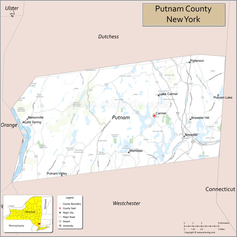
About Putnam County Map, New York: The map showing the county boundary, county seat, major cities, highways, water bodies and neighbouring counties.
More New NY Maps & Info
About Putnam County, New York
Putnam County is a county located in the U.S. state of New York. It's county seat is Carmel Hamlet. As per 2020 census, the population of Putnam County is 97936 people and population density is 398.11 square miles. According to the United States Census Bureau, the county has a total area of 246 sq mi (637 km2). Putnam County was established on 1812.
Facts about Putnam County, New York
| Country | United States |
| State | New York |
| Region | Hudson Valley / Lower Hudson River Valley |
| County Seat | Carmel |
| Founded | 1812 |
| Named For | Israel Putnam (American Revolutionary War & French and Indian War general) |
| Coordinates | ~41.41° N, 73.70° W |
| Total Area | ~246 sq mi |
| Land Area | ~230 sq mi |
| Water Area | ~16 sq mi |
| Water % | ~6.5% |
| Population (2020) | ~97,668 |
| Estimated Population (2024) | ~98,400+ |
| Population Density | ~424/sq mi |
| Largest Town | Carmel (town) |
| Other Towns & Communities | Brewster, Mahopac, Cold Spring, Putnam Valley, Kent, Philipstown, Southeast |
| Main Industries | Services, Retail Trade, Commuter Economy, Tourism |
| Major Highways | I‑84, U.S. 6, NY‑22, NY‑52 |
| Time Zone | Eastern Time (UTC−05:00) |
| Known For | Hudson River scenery, hiking trails & parks, historic villages, easy NYC access |
| Website | https://www.putnamcountyny.com/ |
Top Attractions in Putnam County, New York
- Hudson Highlands State Park – Hiking and river views.
- Fahnestock State Park – Camping and outdoor recreation.
- Putnam County Trailway – Walking and biking trail.
- Boscobel House and Gardens – Historic estate and gardens.
- Cold Spring Village – Shops and riverfront charm.
- Clarence Fahnestock Memorial State Park – Forest trails and lakes.
- West Point Foundry Preserve – Industrial history and trails.
- Lake Gleneida – Town lake and recreation.
- Manitou Marsh – Wetlands and wildlife viewing.
- Putnam History Museum – Local history exhibits.
- Wonder Lake State Park – Swimming and picnicking.
- Stonecrop Gardens – Botanical gardens.
Cities & Towns in Putnam County, New York
Carmel, Brewster, Patterson, Cold Spring, Mahopac, Kent, Philipstown, Putnam Valley, Patterson Center, Nelsonville, Garrison, Pattersonville
- Albany County Map
- Allegany County Map
- Bronx County Map
- Broome County Map
- Cattaraugus County Map
- Cayuga County Map
- Chautauqua County Map
- Chemung County Map
- Chenango County Map
- Clinton County Map
- Columbia County Map
- Cortland County Map
- Delaware County Map
- Dutchess County Map
- Erie County Map
- Essex County Map
- Franklin County Map
- Fulton County Map
- Genesee County Map
- Greene County Map
- Hamilton County Map
- Herkimer County Map
- Jefferson County Map
- Kings County Map
- Lewis County Map
- Livingston County Map
- Madison County Map
- Monroe County Map
- Montgomery County Map
- Nassau County Map
- New York County Map
- Niagara County Map
- Oneida County Map
- Onondaga County Map
- Ontario County Map
- Orange County Map
- Orleans County Map
- Oswego County Map
- Otsego County Map
- Putnam County Map
- Queens County Map
- Rensselaer County Map
- Richmond County Map
- Rockland County Map
- St Lawrence County Map
- Saratoga County Map
- Schenectady County Map
- Schoharie County Map
- Schuyler County Map
- Seneca County Map
- Steuben County Map
- Suffolk County Map
- Sullivan County Map
- Tioga County Map
- Tompkins County Map
- Ulster County Map
- Warren County Map
- Washington County Map
- Wayne County Map
- Westchester County Map
- Wyoming County Map
- Yates County Map
- Alabama Counties
- Alaska boroughs
- Arizona Counties
- Arkansas Counties
- California County Map
- Colorado Counties
- Connecticut Counties
- Delaware Counties
- Florida County Map
- Georgia County Map
- Hawaii Counties
- Idaho Counties
- Illinois Counties
- Indiana Counties
- Iowa Counties
- Kansas Counties
- Kentucky Counties
- Louisiana Counties
- Maine Counties
- Maryland Counties
- Massachusetts Counties
- Michigan County Map
- Minnesota Counties
- Mississippi Counties
- Missouri Counties
- Montana Counties
- Nebraska Counties
- New Hampshire Counties
- New Jersey Counties
- New Mexico Counties
- North Carolina Counties
- North Dakota Counties
- Oklahoma Counties
- Oregon Counties
- Pennsylvania Counties
- Rhode Island Counties
- South Carolina Counties
- South Dakota Counties
- Map of Tennessee
- Texas County Map
- Utah Counties
- Vermont Counties
- Virginia Counties
- Washington Counties
- West Virginia Counties
- Wisconsin Counties
- Wyoming Counties
- Nevada Counties
- New York Counties
- Ohio County Map