Written and Fact-checked by Mukesh Kumar | Updated On: April 256 2026 | 15:50 ET
Map of Ontario County - Ontario County is a county located in the U.S. state of New York. Ontario County Map showing cities, highways, important places and water bodies. Get Where is Ontario County located in the map, major cities in Ontario county, population, areas, and places of interest.
Map of Ontario County, New York
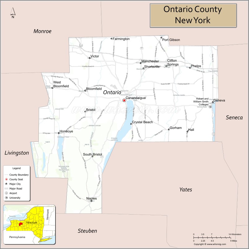
About Ontario County Map, New York: The map showing the county boundary, county seat, major cities, highways, water bodies and neighbouring counties.
Related NY Maps & Info
About Ontario County, New York
Ontario County is a county located in the U.S. state of New York. It's county seat is Canandaigua. As per 2020 census, the population of Ontario County is 112508 people and population density is 169.95 square miles. According to the United States Census Bureau, the county has a total area of 662 sq mi (1,715 km2). Ontario County was established on 1789.
Facts about Ontario County, New York
| Country | United States |
| State | New York |
| Region | Finger Lakes / Western New York |
| County Seat | Canandaigua |
| Founded | January 27, 1789 |
| Named For | Lake Ontario |
| Coordinates | 42.87° N, 77.33° W |
| Total Area | 663 sq mi |
| Land Area | 644 sq mi |
| Water Area | 18 sq mi |
| Water % | 2.8% |
| Population (2020) | 112,458 |
| Estimated Population (2024) | 112,000+ |
| Population Density | 169/sq mi |
| Largest City | Geneva |
| Other Towns & Communities | Canandaigua, Victor, Farmington, Geneva, Phelps, Naples, Richmond |
| Main Industries | Agriculture, Tourism & Wine, Services, Health Care |
| Major Highways | I‑90, U.S. 20 & NY‑5, NY‑14, NY‑21, NY‑96 |
| Time Zone | Eastern Time (UTC−05:00) |
| Known For | Finger Lakes scenery, Canandaigua Lake, wine trails, historic sites |
| Website | https://www.co.ontario.ny.us/ |
Top Attractions in Ontario County, New York
- Canandaigua Lake – Boating and lakeside recreation.
- Sonnenberg Gardens & Mansion State Historic Park – Historic estate and gardens.
- Finger Lakes Wine Country – Wineries and tastings.
- Granger Homestead & Carriage Museum – Historic home and grounds.
- Ontario County Courthouse – Historic government building.
- Roseland Waterpark – Family water park.
- Bristol Mountain – Skiing and scenic views.
- Ganondagan State Historic Site – Seneca history site.
- Canandaigua Lake State Marine Park – Waterfront park.
- CMAC (Constellation Brands–Marvin Sands PAC) – Outdoor concert venue.
- Ontario Pathways Rail Trail – Walking and biking trail.
- Victor Village – Shops and dining.
Cities & Towns in Ontario County, New York
Canandaigua, Geneva, Victor, Farmington, Hopewell, Phelps, Seneca, Richmond, Manchester, Bloomfield, West Bloomfield, Naples, Gorham, South Bristol, East Bloomfield, Bloomfield Center
- Albany County Map
- Allegany County Map
- Bronx County Map
- Broome County Map
- Cattaraugus County Map
- Cayuga County Map
- Chautauqua County Map
- Chemung County Map
- Chenango County Map
- Clinton County Map
- Columbia County Map
- Cortland County Map
- Delaware County Map
- Dutchess County Map
- Erie County Map
- Essex County Map
- Franklin County Map
- Fulton County Map
- Genesee County Map
- Greene County Map
- Hamilton County Map
- Herkimer County Map
- Jefferson County Map
- Kings County Map
- Lewis County Map
- Livingston County Map
- Madison County Map
- Monroe County Map
- Montgomery County Map
- Nassau County Map
- New York County Map
- Niagara County Map
- Oneida County Map
- Onondaga County Map
- Ontario County Map
- Orange County Map
- Orleans County Map
- Oswego County Map
- Otsego County Map
- Putnam County Map
- Queens County Map
- Rensselaer County Map
- Richmond County Map
- Rockland County Map
- St Lawrence County Map
- Saratoga County Map
- Schenectady County Map
- Schoharie County Map
- Schuyler County Map
- Seneca County Map
- Steuben County Map
- Suffolk County Map
- Sullivan County Map
- Tioga County Map
- Tompkins County Map
- Ulster County Map
- Warren County Map
- Washington County Map
- Wayne County Map
- Westchester County Map
- Wyoming County Map
- Yates County Map
- Alabama Counties
- Alaska boroughs
- Arizona Counties
- Arkansas Counties
- California County Map
- Colorado Counties
- Connecticut Counties
- Delaware Counties
- Florida County Map
- Georgia County Map
- Hawaii Counties
- Idaho Counties
- Illinois Counties
- Indiana Counties
- Iowa Counties
- Kansas Counties
- Kentucky Counties
- Louisiana Counties
- Maine Counties
- Maryland Counties
- Massachusetts Counties
- Michigan County Map
- Minnesota Counties
- Mississippi Counties
- Missouri Counties
- Montana Counties
- Nebraska Counties
- Nevada Counties
- New York Counties
- New Hampshire Counties
- New Jersey Counties
- New Mexico Counties
- North Carolina Counties
- North Dakota Counties
- Ohio County Map
- Oklahoma Counties
- Oregon Counties
- Pennsylvania Counties
- Rhode Island Counties
- South Carolina Counties
- South Dakota Counties
- Map of Tennessee
- Texas County Map
- Utah Counties
- Vermont Counties
- Virginia Counties
- Washington Counties
- West Virginia Counties
- Wisconsin Counties
- Wyoming Counties