Written and Fact-checked by Mukesh Kumar | Updated On: April 256 2026 | 15:50 ET
Map of Orleans County - Orleans County is a county located in the U.S. state of New York. Orleans County Map showing cities, highways, important places and water bodies. Get Where is Orleans County located in the map, major cities in Orleans county, population, areas, and places of interest.
Map of Orleans County, New York
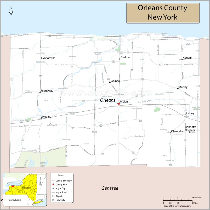
About Orleans County Map, New York: The map showing the county boundary, county seat, major cities, highways, water bodies and neighbouring counties.
Related NY Maps & Info
About Orleans County, New York
Orleans County is a county located in the U.S. state of New York. It's county seat is Albion. As per 2020 census, the population of Orleans County is 40191 people and population density is 49.19 square miles. According to the United States Census Bureau, the county has a total area of 817 sq mi (2,116 km2). Orleans County was established on 1824.
Facts about Orleans County, New York
| Country | United States |
| State | New York |
| Region | Western New York / Finger Lakes & Lake Ontario |
| County Seat | Albion |
| Founded | November 12, 1824 (organized April 15, 1825) |
| Named For | House of Orléans (or possibly Andrew Jackson’s victory at New Orleans) |
| Coordinates | 43.24° N, 78.20° W |
| Total Area | 817 sq mi |
| Land Area | 391 sq mi |
| Water Area | 426 sq mi |
| Water % | 52% |
| Population (2020) | 40,343 |
| Estimated Population (2023) | 39,700+ |
| Population Density | 103/sq mi (land area) |
| Largest Village | Medina |
| Other Towns & Communities | Albion (seat), Holley, Lyndonville, Kendall, Clarendon, Gaines, Murray, Barre, Shelby, Yates |
| Main Industries | Agriculture, Tourism, Services, Small‑scale manufacturing |
| Major Highways | NY‑18, NY‑31, NY‑31A, NY‑63, NY‑98, U.S. 104 |
| Time Zone | Eastern Time (UTC−05:00) |
| Known For | Lake Ontario shoreline, Erie Canal heritage, Oak Orchard & Iroquois National Wildlife Refuge |
| Website | https://www.orleanscountyny.gov/ |
Top Attractions in Orleans County, New York
- Lake Ontario Shoreline – Waterfront views and recreation.
- Medina Sandstone Museum – Local stone and history exhibits.
- Oak Orchard Creek – Fishing and boating waterway.
- Erie Canal Village (Medina) – Canal history and walking paths.
- Millers Bulk Food Bakery – Amish goods and baked items.
- Point Breeze Lighthouse – Historic lakeside lighthouse.
- Oak Orchard State Marine Park – Marina and fishing access.
- Medina Railroad Museum – Railroad history exhibits.
- Barre Falls – Scenic waterfall spot.
- Gaines Basin Lock – Historic Erie Canal lock.
- Knowlesville Artillery Museum – Military artifacts.
- Orleans County Fairgrounds – Events and county fair.
Cities & Towns in Orleans County, New York
Albion, Medina, Lyndonville, Holley, Gaines, Barre, Clarendon, Ridgeway, Carlton, Shelby, Kendall, Yates, Murray, Ridgeway Center
- Albany County Map
- Allegany County Map
- Bronx County Map
- Broome County Map
- Cattaraugus County Map
- Cayuga County Map
- Chautauqua County Map
- Chemung County Map
- Chenango County Map
- Clinton County Map
- Columbia County Map
- Cortland County Map
- Delaware County Map
- Dutchess County Map
- Erie County Map
- Essex County Map
- Franklin County Map
- Fulton County Map
- Genesee County Map
- Greene County Map
- Hamilton County Map
- Herkimer County Map
- Jefferson County Map
- Kings County Map
- Lewis County Map
- Livingston County Map
- Madison County Map
- Monroe County Map
- Montgomery County Map
- Nassau County Map
- New York County Map
- Niagara County Map
- Oneida County Map
- Onondaga County Map
- Ontario County Map
- Orange County Map
- Orleans County Map
- Oswego County Map
- Otsego County Map
- Putnam County Map
- Queens County Map
- Rensselaer County Map
- Richmond County Map
- Rockland County Map
- St Lawrence County Map
- Saratoga County Map
- Schenectady County Map
- Schoharie County Map
- Schuyler County Map
- Seneca County Map
- Steuben County Map
- Suffolk County Map
- Sullivan County Map
- Tioga County Map
- Tompkins County Map
- Ulster County Map
- Warren County Map
- Washington County Map
- Wayne County Map
- Westchester County Map
- Wyoming County Map
- Yates County Map
- Alabama Counties
- Alaska boroughs
- Arizona Counties
- Arkansas Counties
- California County Map
- Colorado Counties
- Connecticut Counties
- Delaware Counties
- Florida County Map
- Georgia County Map
- Hawaii Counties
- Idaho Counties
- Illinois Counties
- Indiana Counties
- Iowa Counties
- Kansas Counties
- Kentucky Counties
- Louisiana Counties
- Maine Counties
- Maryland Counties
- Massachusetts Counties
- Michigan County Map
- Minnesota Counties
- Mississippi Counties
- Missouri Counties
- Montana Counties
- Nebraska Counties
- Nevada Counties
- New York Counties
- New Hampshire Counties
- New Jersey Counties
- New Mexico Counties
- North Carolina Counties
- North Dakota Counties
- Ohio County Map
- Oklahoma Counties
- Oregon Counties
- Pennsylvania Counties
- Rhode Island Counties
- South Carolina Counties
- South Dakota Counties
- Map of Tennessee
- Texas County Map
- Utah Counties
- Vermont Counties
- Virginia Counties
- Washington Counties
- West Virginia Counties
- Wisconsin Counties
- Wyoming Counties