Written and Fact-checked by Mukesh Kumar | Updated On: April 256 2026 | 15:50 ET
Map of Livingston County - Livingston County is a county located in the U.S. state of New York. Livingston County Map showing cities, highways, important places and water bodies. Get Where is Livingston County located in the map, major cities in Livingston county, population, areas, and places of interest.
Map of Livingston County, New York
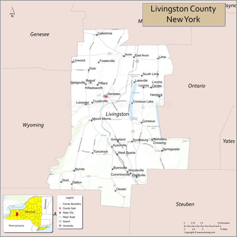
About Livingston County Map, New York: The map showing the county boundary, county seat, major cities, highways, water bodies and neighbouring counties.
Related NY Maps & Info
About Livingston County, New York
Livingston County is a county located in the U.S. state of New York. It's county seat is Geneseo. As per 2020 census, the population of Livingston County is 61578 people and population density is 96.22 square miles. According to the United States Census Bureau, the county has a total area of 640 sq mi (1,658 km2). Livingston County was established on 1821.
Facts about Livingston County, New York
| Country | United States |
| State | New York |
| Region | Finger Lakes / Western New York |
| County Seat | Geneseo |
| Founded | February 23, 1821 |
| Named For | Robert R. Livingston (Founding Father & statesman) |
| Coordinates | 42.80° N, 77.83° W |
| Total Area | 640 sq mi |
| Land Area | 632 sq mi |
| Water Area | 8.5 sq mi |
| Water % | 1.3% |
| Population (2020) | 61,834 |
| Estimated Population (2023) | 61,588 |
| Population Density | 98/sq mi |
| Largest Municipality | Geneseo (town) |
| Other Towns & Communities | Avon, Caledonia, Conesus, Groveland, Leicester, Lima, Livonia, Mount Morris, North Dansville, Nunda, Ossian, Sparta, Springwater, West Sparta, York |
| Main Industries | Agriculture, Education, Healthcare, Services, Manufacturing |
| Major Highways | I‑390, U.S. 20, NY‑36, NY‑39, NY‑63 |
| Time Zone | Eastern Time (UTC−05:00) |
| Known For | Geneseo & SUNY Geneseo, Genesee River, Conesus Lake, Letchworth State Park (partly), rural landscapes |
| Website | https://www.livingstoncountyny.gov/ |
Top Attractions in Livingston County, New York
- Letchworth State Park – Dramatic gorge and waterfalls.
- Genesee River – Scenic river and overlooks.
- Mount Morris Dam – Flood control dam and views.
- National Warplane Museum – Vintage military aircraft.
- Avon Driving Park – Historic harness racing track.
- Genesee Valley Greenway – Hiking and biking trail.
- Dansville ArtWorks – Local arts and events.
- Groveland Ambuscade Park – Forested recreation area.
- Stony Brook State Park – Gorge trails and waterfalls.
- Conesus Lake – Boating and fishing lake.
- Genesee Country Village & Museum (nearby) – Living history museum.
- Avon Village Historic District – Shops and historic buildings.
Cities & Towns in Livingston County, New York
Geneseo, Dansville, Mount Morris, Avon, Caledonia, Leicester, Lima, Groveland, Conesus, Nunda, York, Livonia, Sparta, West Sparta, Leicester Center, Lakeville
- Albany County Map
- Allegany County Map
- Bronx County Map
- Broome County Map
- Cattaraugus County Map
- Cayuga County Map
- Chautauqua County Map
- Chemung County Map
- Chenango County Map
- Clinton County Map
- Columbia County Map
- Cortland County Map
- Delaware County Map
- Dutchess County Map
- Erie County Map
- Essex County Map
- Franklin County Map
- Fulton County Map
- Genesee County Map
- Greene County Map
- Hamilton County Map
- Herkimer County Map
- Jefferson County Map
- Kings County Map
- Lewis County Map
- Livingston County Map
- Madison County Map
- Monroe County Map
- Montgomery County Map
- Nassau County Map
- New York County Map
- Niagara County Map
- Oneida County Map
- Onondaga County Map
- Ontario County Map
- Orange County Map
- Orleans County Map
- Oswego County Map
- Otsego County Map
- Putnam County Map
- Queens County Map
- Rensselaer County Map
- Richmond County Map
- Rockland County Map
- St Lawrence County Map
- Saratoga County Map
- Schenectady County Map
- Schoharie County Map
- Schuyler County Map
- Seneca County Map
- Steuben County Map
- Suffolk County Map
- Sullivan County Map
- Tioga County Map
- Tompkins County Map
- Ulster County Map
- Warren County Map
- Washington County Map
- Wayne County Map
- Westchester County Map
- Wyoming County Map
- Yates County Map
- Alabama Counties
- Alaska boroughs
- Arizona Counties
- Arkansas Counties
- California County Map
- Colorado Counties
- Connecticut Counties
- Delaware Counties
- Florida County Map
- Georgia County Map
- Hawaii Counties
- Idaho Counties
- Illinois Counties
- Indiana Counties
- Iowa Counties
- Kansas Counties
- Kentucky Counties
- Louisiana Counties
- Maine Counties
- Maryland Counties
- Massachusetts Counties
- Michigan County Map
- Minnesota Counties
- Mississippi Counties
- Missouri Counties
- Montana Counties
- Nebraska Counties
- Nevada Counties
- New York Counties
- New Hampshire Counties
- New Jersey Counties
- New Mexico Counties
- North Carolina Counties
- North Dakota Counties
- Ohio County Map
- Oklahoma Counties
- Oregon Counties
- Pennsylvania Counties
- Rhode Island Counties
- South Carolina Counties
- South Dakota Counties
- Map of Tennessee
- Texas County Map
- Utah Counties
- Vermont Counties
- Virginia Counties
- Washington Counties
- West Virginia Counties
- Wisconsin Counties
- Wyoming Counties