Written and Fact-checked by Mukesh Kumar | Updated On: April 256 2026 | 15:50 ET
Map of Richmond County - Richmond County is a county located in the U.S. state of New York. Richmond County Map showing cities, highways, important places and water bodies. Get Where is Richmond County located in the map, major cities in Richmond county, population, areas, and places of interest.
Map of Richmond County, New York
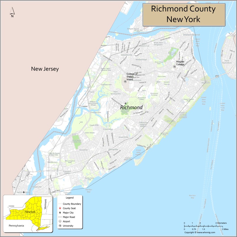
About Richmond County Map, New York: The map showing the county boundary, county seat, major cities, highways, water bodies and neighbouring counties.
Related NY Maps & Info
About Richmond County, New York
Richmond County is a county located in the U.S. state of New York. It's county seat is none (sui generis). As per 2020 census, the population of Richmond County is 493494 people and population density is 4814.58 square miles. According to the United States Census Bureau, the county has a total area of 102.5 sq mi (265 km2). Richmond County was established on 1683.
Facts about Richmond County, New York
| Country | United States |
| State | New York |
| Region | New York City / Southern New York |
| County Seat | Staten Island (coextensive with borough) |
| Founded | 1683 (organized as county) |
| Named For | Charles Lennox, 1st Duke of Richmond |
| Coordinates | 40.58° N, 74.15° W |
| Total Area | 102.5 sq mi |
| Land Area | 58.5 sq mi |
| Water Area | 44.0 sq mi |
| Water % | 43% |
| Population (2020) | 495,747 |
| Estimated Population (2023) | 490,687 |
| Population Density | 8,530/sq mi (land area) |
| Largest Municipality | Staten Island (borough) |
| Other Neighborhoods | St. George, Tottenville, New Dorp, West Brighton, Tompkinsville, Clifton |
| Main Industries | Services, Transportation, Healthcare, Education, Retail |
| Major Highways | I‑278, Staten Island Expressway, NY‑440 |
| Time Zone | Eastern Time (UTC−05:00) |
| Known For | Staten Island Ferry, parks & green spaces, suburban neighborhoods, historic sites |
| Website | https://www.nyc.gov/boroughs/staten-island |
Top Attractions in Richmond County, New York
- Staten Island Ferry – Free harbor ferry with skyline views.
- Staten Island Museum – Art, science, and history exhibits.
- Historic Richmond Town – Living history village.
- Snug Harbor Cultural Center & Botanical Garden – Arts campus and gardens.
- Staten Island Zoo – Family-friendly animal exhibits.
- South Beach Boardwalk – Waterfront walking and beach area.
- Conference House Park – Historic site and waterfront park.
- Fort Wadsworth – Historic fort with harbor views.
- High Rock Park – Nature trails and scenery.
- Clay Pit Ponds State Park Preserve – Wetlands and wildlife.
- St. George Theatre – Historic performing arts venue.
- Freshkills Park – Expansive park and green space.
Cities & Towns in Richmond County, New York
Staten Island, St. George, Tottenville, Great Kills, New Dorp, Port Richmond, Stapleton, Mariners Harbor, Oakwood, Rosebank, Fort Wadsworth, Tompkinsville, Clifton, South Beach, Eltingville, Midland Beach
- Albany County Map
- Allegany County Map
- Bronx County Map
- Broome County Map
- Cattaraugus County Map
- Cayuga County Map
- Chautauqua County Map
- Chemung County Map
- Chenango County Map
- Clinton County Map
- Columbia County Map
- Cortland County Map
- Delaware County Map
- Dutchess County Map
- Erie County Map
- Essex County Map
- Franklin County Map
- Fulton County Map
- Genesee County Map
- Greene County Map
- Hamilton County Map
- Herkimer County Map
- Jefferson County Map
- Kings County Map
- Lewis County Map
- Livingston County Map
- Madison County Map
- Monroe County Map
- Montgomery County Map
- Nassau County Map
- New York County Map
- Niagara County Map
- Oneida County Map
- Onondaga County Map
- Ontario County Map
- Orange County Map
- Orleans County Map
- Oswego County Map
- Otsego County Map
- Putnam County Map
- Queens County Map
- Rensselaer County Map
- Richmond County Map
- Rockland County Map
- St Lawrence County Map
- Saratoga County Map
- Schenectady County Map
- Schoharie County Map
- Schuyler County Map
- Seneca County Map
- Steuben County Map
- Suffolk County Map
- Sullivan County Map
- Tioga County Map
- Tompkins County Map
- Ulster County Map
- Warren County Map
- Washington County Map
- Wayne County Map
- Westchester County Map
- Wyoming County Map
- Yates County Map
- Alabama Counties
- Alaska boroughs
- Arizona Counties
- Arkansas Counties
- California County Map
- Colorado Counties
- Connecticut Counties
- Delaware Counties
- Florida County Map
- Georgia County Map
- Hawaii Counties
- Idaho Counties
- Illinois Counties
- Indiana Counties
- Iowa Counties
- Kansas Counties
- Kentucky Counties
- Louisiana Counties
- Maine Counties
- Maryland Counties
- Massachusetts Counties
- Michigan County Map
- Minnesota Counties
- Mississippi Counties
- Missouri Counties
- Montana Counties
- Nebraska Counties
- Nevada Counties
- New York Counties
- New Hampshire Counties
- New Jersey Counties
- New Mexico Counties
- North Carolina Counties
- North Dakota Counties
- Ohio County Map
- Oklahoma Counties
- Oregon Counties
- Pennsylvania Counties
- Rhode Island Counties
- South Carolina Counties
- South Dakota Counties
- Map of Tennessee
- Texas County Map
- Utah Counties
- Vermont Counties
- Virginia Counties
- Washington Counties
- West Virginia Counties
- Wisconsin Counties
- Wyoming Counties