Written and Fact-checked by Mukesh Kumar | Updated On: April 256 2026 | 15:50 ET
Map of Clinton County - Clinton County is a county located in the U.S. state of New York. Clinton County Map showing cities, highways, important places and water bodies. Get Where is Clinton County located in the map, major cities in Clinton county, population, areas, and places of interest.
Map of Clinton County, New York
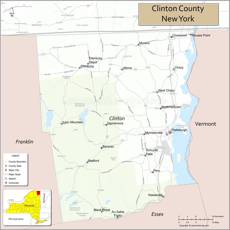
About Clinton County Map, New York: The map showing the county boundary, county seat, major cities, highways, water bodies and neighbouring counties.
Related NY Maps & Info
About Clinton County, New York
Clinton County is a county located in the U.S. state of New York. It's county seat is Plattsburgh. As per 2020 census, the population of Clinton County is 79596 people and population density is 71.19 square miles. According to the United States Census Bureau, the county has a total area of 1,118 sq mi (2,896 km2). Clinton County was established on 1788.
Facts about Clinton County, New York
| Country | United States |
| State | New York |
| Region | Northern New York / North Country |
| County Seat | Plattsburgh |
| Founded | 1788 |
| Named For | George Clinton (first Governor of New York & U.S. Vice President) |
| Coordinates | 44.69° N, 73.45° W |
| Total Area | 1,117.5 sq mi |
| Land Area | 1,037.9 sq mi |
| Water Area | 80 sq mi |
| Water % | 7.1% |
| Population (2020) | 79,843 |
| Estimated Population (2025) | 77,859 (projected) |
| Population Density | 71/sq mi |
| Largest City | Plattsburgh |
| Other Cities & Towns | Peru, Dannemora, Rouses Point, Champlain, Beekmantown, Au Sable Forks |
| Main Industries | Services, Tourism, Education, Healthcare |
| Major Highways | I‑87, U.S. 9, NY‑22, NY‑3, NY‑374 |
| Time Zone | Eastern Time (UTC−05:00) |
| Known For | Lake Champlain shoreline, Adirondack landscapes, historical sites & outdoor recreation |
| Website | https://www.clintoncountyny.gov/ |
Top Attractions in Clinton County, New York
- Lake Champlain – Boating, fishing, and lake views.
- Ausable Chasm – Scenic sandstone gorge and trails.
- Battle of Plattsburgh Interpretive Center – War of 1812 history.
- Plattsburgh City Beach – Sandy beach on Lake Champlain.
- Kent Delord House Museum – Historic 19th-century home.
- Clinton County Historical Museum – Local history exhibits.
- Point Au Roche State Park – Camping and waterfront recreation.
- Valcour Island – Historic island and boating destination.
- Adirondack Coast Wine Trail – Wineries and tastings.
- Feinberg Library – Historic library and architecture.
- Plattsburgh Air Force Base Museum – Military aviation history.
- Saranac River – Fishing and paddling river.
Cities & Towns in Clinton County, New York
Plattsburgh, Champlain, Peru, Morrisonville, Beekmantown, Dannemora, Saranac, Altona, Ausable, Mooers, Rouses Point, Chazy, Ellenburg, West Chazy, Lyon Mountain
- Albany County Map
- Allegany County Map
- Bronx County Map
- Broome County Map
- Cattaraugus County Map
- Cayuga County Map
- Chautauqua County Map
- Chemung County Map
- Chenango County Map
- Clinton County Map
- Columbia County Map
- Cortland County Map
- Delaware County Map
- Dutchess County Map
- Erie County Map
- Essex County Map
- Franklin County Map
- Fulton County Map
- Genesee County Map
- Greene County Map
- Hamilton County Map
- Herkimer County Map
- Jefferson County Map
- Kings County Map
- Lewis County Map
- Livingston County Map
- Madison County Map
- Monroe County Map
- Montgomery County Map
- Nassau County Map
- New York County Map
- Niagara County Map
- Oneida County Map
- Onondaga County Map
- Ontario County Map
- Orange County Map
- Orleans County Map
- Oswego County Map
- Otsego County Map
- Putnam County Map
- Queens County Map
- Rensselaer County Map
- Richmond County Map
- Rockland County Map
- St Lawrence County Map
- Saratoga County Map
- Schenectady County Map
- Schoharie County Map
- Schuyler County Map
- Seneca County Map
- Steuben County Map
- Suffolk County Map
- Sullivan County Map
- Tioga County Map
- Tompkins County Map
- Ulster County Map
- Warren County Map
- Washington County Map
- Wayne County Map
- Westchester County Map
- Wyoming County Map
- Yates County Map
- Alabama Counties
- Alaska boroughs
- Arizona Counties
- Arkansas Counties
- California County Map
- Colorado Counties
- Connecticut Counties
- Delaware Counties
- Florida County Map
- Georgia County Map
- Hawaii Counties
- Idaho Counties
- Illinois Counties
- Indiana Counties
- Iowa Counties
- Kansas Counties
- Kentucky Counties
- Louisiana Counties
- Maine Counties
- Maryland Counties
- Massachusetts Counties
- Michigan County Map
- Minnesota Counties
- Mississippi Counties
- Missouri Counties
- Montana Counties
- Nebraska Counties
- Nevada Counties
- New York Counties
- New Hampshire Counties
- New Jersey Counties
- New Mexico Counties
- North Carolina Counties
- North Dakota Counties
- Ohio County Map
- Oklahoma Counties
- Oregon Counties
- Pennsylvania Counties
- Rhode Island Counties
- South Carolina Counties
- South Dakota Counties
- Map of Tennessee
- Texas County Map
- Utah Counties
- Vermont Counties
- Virginia Counties
- Washington Counties
- West Virginia Counties
- Wisconsin Counties
- Wyoming Counties