Written and Fact-checked by Mukesh Kumar | Updated On: April 256 2026 | 15:50 ET
Map of Schenectady County - Schenectady County is a county located in the U.S. state of New York. Schenectady County Map showing cities, highways, important places and water bodies. Get Where is Schenectady County located in the map, major cities in Schenectady county, population, areas, and places of interest.
Map of Schenectady County, New York
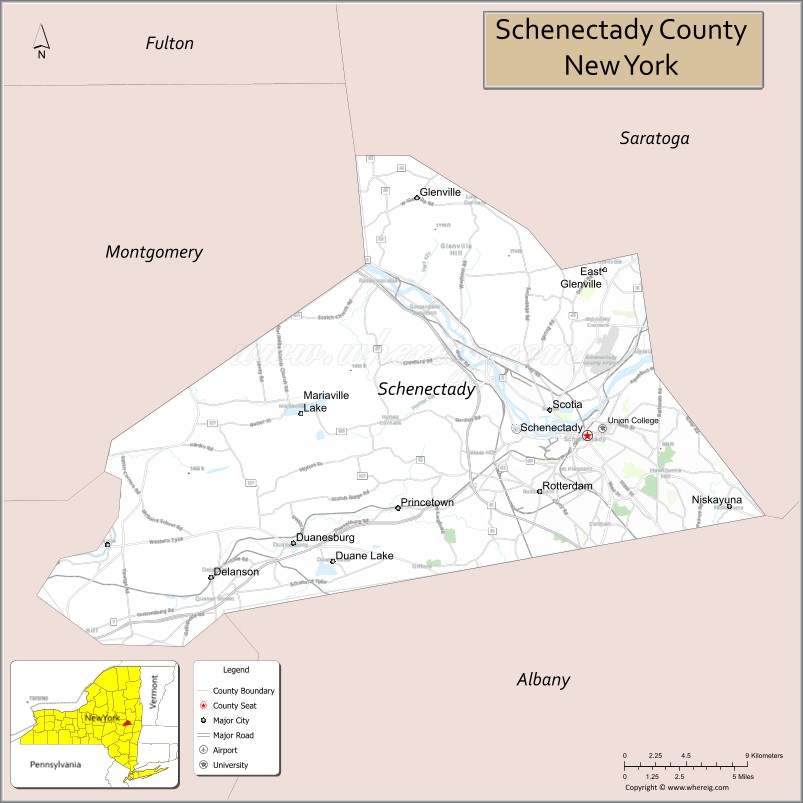
About Schenectady County Map, New York: The map showing the county boundary, county seat, major cities, highways, water bodies and neighbouring counties.
Related NY Maps & Info
About Schenectady County, New York
Schenectady County is a county located in the U.S. state of New York. It's county seat is Schenectady. As per 2020 census, the population of Schenectady County is 158089 people and population density is 752.8 square miles. According to the United States Census Bureau, the county has a total area of 210 sq mi (544 km2). Schenectady County was established on 1809.
Facts about Schenectady County, New York
| Country | United States |
| State | New York |
| Region | Capital District / Eastern New York |
| County Seat | Schenectady |
| Founded | 1809 |
| Named For | Derived from a Mohawk word probably meaning “the other side of the pinelands” / “beyond the pines” |
| Coordinates | 42.81° N, 73.93° W |
| Total Area | 206 sq mi |
| Land Area | 200 sq mi |
| Water Area | 6 sq mi |
| Water % | 3% |
| Population (2020) | 158,061 |
| Estimated Population (2024) | 162,000+ |
| Population Density | 781/sq mi (land area) |
| Largest City | Schenectady |
| Other Towns & Communities | Rotterdam, Niskayuna, Glenville, Princetown |
| Main Industries | Services, Manufacturing, Technology, Healthcare, Education |
| Major Highways | I‑890, I‑90 (nearby), NY‑5, NY‑7 |
| Time Zone | Eastern Time (UTC−05:00) |
| Known For | Mohawk River corridor, Union College, General Electric heritage, Erie Canal history |
| Website | https://www.schenectadycounty.com/ |
Top Attractions in Schenectady County, New York
- Proctors Theatre – Historic performing arts venue.
- Central Park (Schenectady) – Large urban park.
- Rivers Casino & Resort Schenectady – Gaming and entertainment.
- Stockade Historic District – Colonial-era neighborhood.
- miSci | Museum of Innovation and Science – Science and technology exhibits.
- Schenectady County Historical Society – Local history museum.
- Mohawk River Bike-Hike Trail – Scenic riverfront path.
- Union College Campus – Historic college architecture.
- Great Flats Nature Trail – Wetland boardwalk trail.
- ViaPort Rotterdam – Shopping and dining center.
- Liberty Park – Riverfront park and events.
- Plotter Kill Preserve – Waterfalls and hiking trails.
Cities & Towns in Schenectady County, New York
Schenectady, Rotterdam, Niskayuna, Scotia, Glenville, Duanesburg, Princetown, Mariaville, Delanson, Amsterdam (partly), Rotterdam Junction
- Albany County Map
- Allegany County Map
- Bronx County Map
- Broome County Map
- Cattaraugus County Map
- Cayuga County Map
- Chautauqua County Map
- Chemung County Map
- Chenango County Map
- Clinton County Map
- Columbia County Map
- Cortland County Map
- Delaware County Map
- Dutchess County Map
- Erie County Map
- Essex County Map
- Franklin County Map
- Fulton County Map
- Genesee County Map
- Greene County Map
- Hamilton County Map
- Herkimer County Map
- Jefferson County Map
- Kings County Map
- Lewis County Map
- Livingston County Map
- Madison County Map
- Monroe County Map
- Montgomery County Map
- Nassau County Map
- New York County Map
- Niagara County Map
- Oneida County Map
- Onondaga County Map
- Ontario County Map
- Orange County Map
- Orleans County Map
- Oswego County Map
- Otsego County Map
- Putnam County Map
- Queens County Map
- Rensselaer County Map
- Richmond County Map
- Rockland County Map
- St Lawrence County Map
- Saratoga County Map
- Schenectady County Map
- Schoharie County Map
- Schuyler County Map
- Seneca County Map
- Steuben County Map
- Suffolk County Map
- Sullivan County Map
- Tioga County Map
- Tompkins County Map
- Ulster County Map
- Warren County Map
- Washington County Map
- Wayne County Map
- Westchester County Map
- Wyoming County Map
- Yates County Map
- Alabama Counties
- Alaska boroughs
- Arizona Counties
- Arkansas Counties
- California County Map
- Colorado Counties
- Connecticut Counties
- Delaware Counties
- Florida County Map
- Georgia County Map
- Hawaii Counties
- Idaho Counties
- Illinois Counties
- Indiana Counties
- Iowa Counties
- Kansas Counties
- Kentucky Counties
- Louisiana Counties
- Maine Counties
- Maryland Counties
- Massachusetts Counties
- Michigan County Map
- Minnesota Counties
- Mississippi Counties
- Missouri Counties
- Montana Counties
- Nebraska Counties
- Nevada Counties
- New York Counties
- New Hampshire Counties
- New Jersey Counties
- New Mexico Counties
- North Carolina Counties
- North Dakota Counties
- Ohio County Map
- Oklahoma Counties
- Oregon Counties
- Pennsylvania Counties
- Rhode Island Counties
- South Carolina Counties
- South Dakota Counties
- Map of Tennessee
- Texas County Map
- Utah Counties
- Vermont Counties
- Virginia Counties
- Washington Counties
- West Virginia Counties
- Wisconsin Counties
- Wyoming Counties