Written and Fact-checked by Mukesh Kumar | Updated On: April 256 2026 | 15:50 ET
Map of Schoharie County - Schoharie County is a county located in the U.S. state of New York. Schoharie County Map showing cities, highways, important places and water bodies. Get Where is Schoharie County located in the map, major cities in Schoharie county, population, areas, and places of interest.
Map of Schoharie County, New York
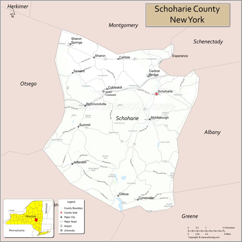
About Schoharie County Map, New York: The map showing the county boundary, county seat, major cities, highways, water bodies and neighbouring counties.
Related NY Maps & Info
About Schoharie County, New York
Schoharie County is a county located in the U.S. state of New York. It's county seat is Schoharie. As per 2020 census, the population of Schoharie County is 29863 people and population density is 47.7 square miles. According to the United States Census Bureau, the county has a total area of 626 sq mi (1,621 km2). Schoharie County was established on 1795.
Facts about Schoharie County, New York
| Country | United States |
| State | New York |
| Region | Central New York / Mohawk Valley |
| County Seat | Schoharie (village) |
| Founded | April 6, 1795 |
| Named For | Mohawk word meaning “floating driftwood” |
| Coordinates | 42.67° N, 74.31° W |
| Total Area | 626 sq mi |
| Land Area | 622 sq mi |
| Water Area | 4.5 sq mi |
| Water % | 0.7% |
| Population (2020) | 29,714 |
| Estimated Population (2024) | 30,151 |
| Population Density | 48/sq mi |
| Largest Municipality | Cobleskill (village) |
| Other Towns & Communities | Schoharie, Middleburgh, Blenheim, Sharon Springs, Esperance |
| Main Industries | Agriculture, Tourism, Small business, Services |
| Major Highways | NY‑7, NY‑30, NY‑145, I‑88 (nearby) |
| Time Zone | Eastern Time (UTC−05:00) |
| Known For | Historic Schoharie Valley, Howe Caverns, Vroman’s Nose, rural landscapes |
| Website | https://www.schohariecounty-ny.gov/ |
Top Attractions in Schoharie County, New York
- Schoharie Crossing State Historic Site – Erie Canal history and trails.
- Howes Cave & Secret Caverns – Underground cave tours.
- Vroman’s Nose – Popular hiking viewpoint.
- Old Stone Fort Museum – Revolutionary War-era fort.
- Schoharie Creek – Fishing and scenic views.
- Central Bridge Historic District – Village charm and architecture.
- Gilboa Fossil Forest – Prehistoric fossil site.
- Schoharie Valley Farms – Rural scenery and local products.
- Huntersland Road Covered Bridge – Historic covered bridge.
- Max V. Shaul State Park Preserve – Creekside trails.
- Breakabeen Covered Bridge – Historic wooden bridge.
- Schoharie County Historical Society – Local history exhibits.
Cities & Towns in Schoharie County, New York
Schoharie, Cobleskill, Middleburgh, Sharon Springs, Fulton, Summit, Carlisle, Gilboa, Jefferson, Wright, Sharon, Esperance, Richmondville, Broome, Blenheim, Charleston, Conesville, Seward, Gilboa Center
- Albany County Map
- Allegany County Map
- Bronx County Map
- Broome County Map
- Cattaraugus County Map
- Cayuga County Map
- Chautauqua County Map
- Chemung County Map
- Chenango County Map
- Clinton County Map
- Columbia County Map
- Cortland County Map
- Delaware County Map
- Dutchess County Map
- Erie County Map
- Essex County Map
- Franklin County Map
- Fulton County Map
- Genesee County Map
- Greene County Map
- Hamilton County Map
- Herkimer County Map
- Jefferson County Map
- Kings County Map
- Lewis County Map
- Livingston County Map
- Madison County Map
- Monroe County Map
- Montgomery County Map
- Nassau County Map
- New York County Map
- Niagara County Map
- Oneida County Map
- Onondaga County Map
- Ontario County Map
- Orange County Map
- Orleans County Map
- Oswego County Map
- Otsego County Map
- Putnam County Map
- Queens County Map
- Rensselaer County Map
- Richmond County Map
- Rockland County Map
- St Lawrence County Map
- Saratoga County Map
- Schenectady County Map
- Schoharie County Map
- Schuyler County Map
- Seneca County Map
- Steuben County Map
- Suffolk County Map
- Sullivan County Map
- Tioga County Map
- Tompkins County Map
- Ulster County Map
- Warren County Map
- Washington County Map
- Wayne County Map
- Westchester County Map
- Wyoming County Map
- Yates County Map
- Alabama Counties
- Alaska boroughs
- Arizona Counties
- Arkansas Counties
- California County Map
- Colorado Counties
- Connecticut Counties
- Delaware Counties
- Florida County Map
- Georgia County Map
- Hawaii Counties
- Idaho Counties
- Illinois Counties
- Indiana Counties
- Iowa Counties
- Kansas Counties
- Kentucky Counties
- Louisiana Counties
- Maine Counties
- Maryland Counties
- Massachusetts Counties
- Michigan County Map
- Minnesota Counties
- Mississippi Counties
- Missouri Counties
- Montana Counties
- Nebraska Counties
- Nevada Counties
- New York Counties
- New Hampshire Counties
- New Jersey Counties
- New Mexico Counties
- North Carolina Counties
- North Dakota Counties
- Ohio County Map
- Oklahoma Counties
- Oregon Counties
- Pennsylvania Counties
- Rhode Island Counties
- South Carolina Counties
- South Dakota Counties
- Map of Tennessee
- Texas County Map
- Utah Counties
- Vermont Counties
- Virginia Counties
- Washington Counties
- West Virginia Counties
- Wisconsin Counties
- Wyoming Counties