Written and Fact-checked by Mukesh Kumar | Updated On: April 256 2026 | 15:50 ET
Map of Schuyler County - Schuyler County is a county located in the U.S. state of New York. Schuyler County Map showing cities, highways, important places and water bodies. Get Where is Schuyler County located in the map, major cities in Schuyler county, population, areas, and places of interest.
Map of Schuyler County, New York
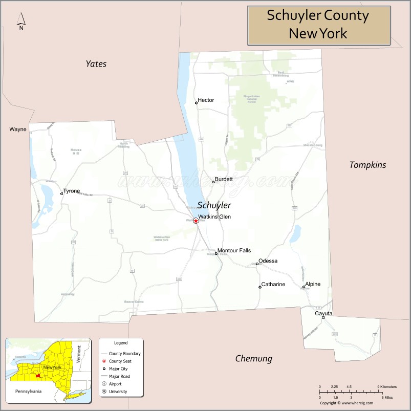
About Schuyler County Map, New York: The map showing the county boundary, county seat, major cities, highways, water bodies and neighbouring counties.
Related NY Maps & Info
About Schuyler County, New York
Schuyler County is a county located in the U.S. state of New York. It's county seat is Watkins Glen. As per 2020 census, the population of Schuyler County is 17752 people and population density is 51.91 square miles. According to the United States Census Bureau, the county has a total area of 342 sq mi (886 km2). Schuyler County was established on 1854.
Facts about Schuyler County, New York
| Country | United States |
| State | New York |
| Region | Finger Lakes / Southern Tier area |
| County Seat | Watkins Glen |
| Founded | April 17, 1854 |
| Named For | Philip Schuyler (Revolutionary War general & statesman) |
| Coordinates | 42.38° N, 76.87° W |
| Total Area | 342 sq mi |
| Land Area | 328 sq mi |
| Water Area | 14 sq mi |
| Water % | 4.1% |
| Population (2020) | 17,898 |
| Estimated Population (2024) | 17,100‑17,800+ |
| Population Density | 54.5/sq mi |
| Largest Community | Hector (town) / Watkins Glen (seat) |
| Other Towns & Villages | Catharine, Cayuta, Dix, Montour, Orange, Reading, Tyrone; Montour Falls, Odessa, Burdett |
| Main Industries | Agriculture, Tourism (wine & nature), Services, Motorsports events |
| Major Highways | NY‑14, NY‑13, NY‑14A |
| Time Zone | Eastern Time (UTC−05:00) |
| Known For | Watkins Glen State Park, Seneca Lake vineyards, Finger Lakes National Forest, Watkins Glen International racetrack |
| Website | https://www.schuylercountyny.gov/ |
Top Attractions in Schuyler County, New York
- Watkins Glen State Park – Dramatic gorge and waterfalls.
- Watkins Glen International – Auto racing track.
- Seneca Lake – Boating and lakeside views.
- Finger Lakes National Forest (nearby) – Hiking and camping.
- Clute Park – Lakeside park and marina.
- Montour Falls – Village waterfall scenery.
- Hector Falls – Tall roadside waterfall.
- Glen Creek Gorge – Scenic hiking area.
- Finger Lakes Wine Trail – Wineries and tastings.
- Brick Tavern Stand Museum – Historic tavern museum.
- Catharine Valley Trail – Walking and biking path.
- Queen Catharine Marsh – Wildlife viewing area.
Cities & Towns in Schuyler County, New York
Watkins Glen, Montour Falls, Odessa, Burdett, Tyrone, Beaver Dams, Dix, Catharine, Reynoldsville, Beaver Dams West, Hector (partly)
- Albany County Map
- Allegany County Map
- Bronx County Map
- Broome County Map
- Cattaraugus County Map
- Cayuga County Map
- Chautauqua County Map
- Chemung County Map
- Chenango County Map
- Clinton County Map
- Columbia County Map
- Cortland County Map
- Delaware County Map
- Dutchess County Map
- Erie County Map
- Essex County Map
- Franklin County Map
- Fulton County Map
- Genesee County Map
- Greene County Map
- Hamilton County Map
- Herkimer County Map
- Jefferson County Map
- Kings County Map
- Lewis County Map
- Livingston County Map
- Madison County Map
- Monroe County Map
- Montgomery County Map
- Nassau County Map
- New York County Map
- Niagara County Map
- Oneida County Map
- Onondaga County Map
- Ontario County Map
- Orange County Map
- Orleans County Map
- Oswego County Map
- Otsego County Map
- Putnam County Map
- Queens County Map
- Rensselaer County Map
- Richmond County Map
- Rockland County Map
- St Lawrence County Map
- Saratoga County Map
- Schenectady County Map
- Schoharie County Map
- Schuyler County Map
- Seneca County Map
- Steuben County Map
- Suffolk County Map
- Sullivan County Map
- Tioga County Map
- Tompkins County Map
- Ulster County Map
- Warren County Map
- Washington County Map
- Wayne County Map
- Westchester County Map
- Wyoming County Map
- Yates County Map
- Alabama Counties
- Alaska boroughs
- Arizona Counties
- Arkansas Counties
- California County Map
- Colorado Counties
- Connecticut Counties
- Delaware Counties
- Florida County Map
- Georgia County Map
- Hawaii Counties
- Idaho Counties
- Illinois Counties
- Indiana Counties
- Iowa Counties
- Kansas Counties
- Kentucky Counties
- Louisiana Counties
- Maine Counties
- Maryland Counties
- Massachusetts Counties
- Michigan County Map
- Minnesota Counties
- Mississippi Counties
- Missouri Counties
- Montana Counties
- Nebraska Counties
- Nevada Counties
- New York Counties
- New Hampshire Counties
- New Jersey Counties
- New Mexico Counties
- North Carolina Counties
- North Dakota Counties
- Ohio County Map
- Oklahoma Counties
- Oregon Counties
- Pennsylvania Counties
- Rhode Island Counties
- South Carolina Counties
- South Dakota Counties
- Map of Tennessee
- Texas County Map
- Utah Counties
- Vermont Counties
- Virginia Counties
- Washington Counties
- West Virginia Counties
- Wisconsin Counties
- Wyoming Counties