Written and Fact-checked by Mukesh Kumar | Updated On: April 256 2026 | 15:50 ET
Map of Oswego County - Oswego County is a county located in the U.S. state of New York. Oswego County Map showing cities, highways, important places and water bodies. Get Where is Oswego County located in the map, major cities in Oswego county, population, areas, and places of interest.
Map of Oswego County, New York
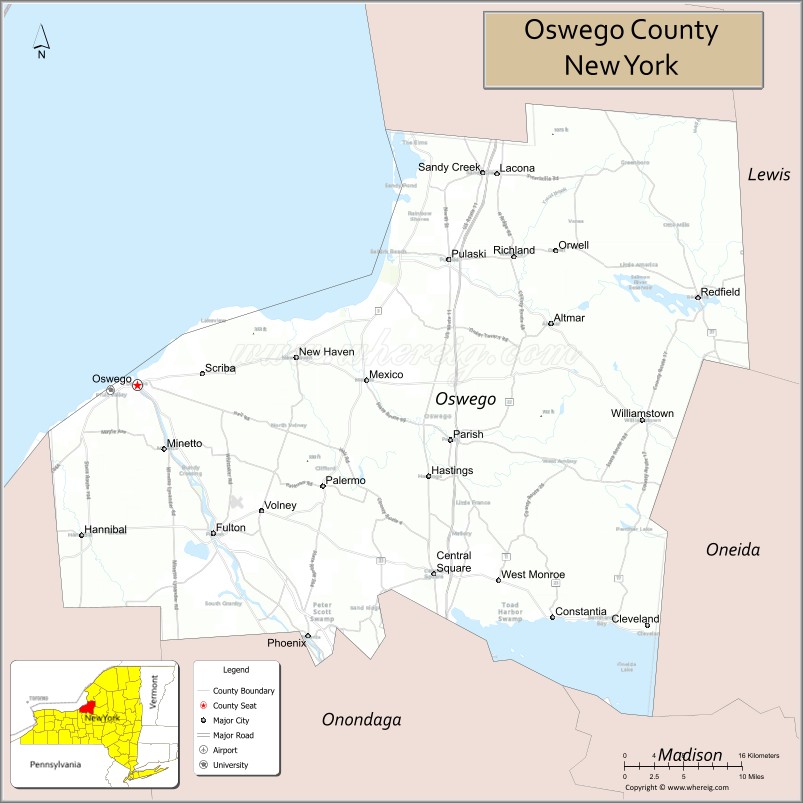
About Oswego County Map, New York: The map showing the county boundary, county seat, major cities, highways, water bodies and neighbouring counties.
Related NY Maps & Info
About Oswego County, New York
Oswego County is a county located in the U.S. state of New York. It's county seat is Oswego. As per 2020 census, the population of Oswego County is 117387 people and population density is 89.47 square miles. According to the United States Census Bureau, the county has a total area of 1,312 sq mi (3,398 km2). Oswego County was established on 1816.
Facts about Oswego County, New York
| Country | United States |
| State | New York |
| Region | Central New York / Lake Ontario region |
| County Seat | Oswego |
| Founded | March 1, 1816 |
| Named For | Mohawk/Central New York word meaning “a pouring out place” (Oswego River into Lake Ontario) |
| Coordinates | 43.40° N, 76.50° W |
| Total Area | 1,312 sq mi |
| Land Area | 952 sq mi |
| Water Area | 360 sq mi |
| Water % | 27% |
| Population (2020) | 117,525 |
| Estimated Population (2024) | 115,000+ |
| Population Density | 123/sq mi |
| Largest City | Oswego |
| Other Cities & Towns | Fulton, Mexico, Phoenix, Central Square, Pulaski, Hannibal, Albion |
| Main Industries | Manufacturing, Services, Agriculture, Education, Healthcare |
| Major Highways | I‑81, NY‑3, NY‑104, NY‑13, NY‑49 |
| Time Zone | Eastern Time (UTC−05:00) |
| Known For | Lake Ontario shoreline, Oswego River & canal connections, Fort Ontario historic site, SUNY Oswego |
| Website | https://www.oswegocountyny.gov/ |
Top Attractions in Oswego County, New York
- Fort Ontario State Historic Site – Military history and views.
- Lake Ontario Waterfront – Beaches and shoreline parks.
- Salmon River Fish Hatchery – Salmon fishing and exhibits.
- Safe Haven Holocaust Refugee Museum – World War II history.
- Oswego Harbor West Pierhead Lighthouse – Historic harbor lighthouse.
- Selkirk Shores State Park – Camping and lake views.
- Salmon River Falls – Tall scenic waterfall.
- William’s Beach State Park – Sandy swimming beach.
- Chimney Bluffs State Park (nearby) – Dramatic shoreline bluffs.
- Richardson-Bates House Museum – Historic home museum.
- Oswego Speedway – Auto racing venue.
- Great Bear Springs Recreation Area – Hiking and picnics.
Cities & Towns in Oswego County, New York
Oswego, Fulton, Mexico, Pulaski, Central Square, Hannibal, Sandy Creek, Volney, Scriba, Minetto, Granby, Williamstown, Phoenix, Parish, Orwell, Richland, Palermo, Lacona, Sandy Creek Center
- Albany County Map
- Allegany County Map
- Bronx County Map
- Broome County Map
- Cattaraugus County Map
- Cayuga County Map
- Chautauqua County Map
- Chemung County Map
- Chenango County Map
- Clinton County Map
- Columbia County Map
- Cortland County Map
- Delaware County Map
- Dutchess County Map
- Erie County Map
- Essex County Map
- Franklin County Map
- Fulton County Map
- Genesee County Map
- Greene County Map
- Hamilton County Map
- Herkimer County Map
- Jefferson County Map
- Kings County Map
- Lewis County Map
- Livingston County Map
- Madison County Map
- Monroe County Map
- Montgomery County Map
- Nassau County Map
- New York County Map
- Niagara County Map
- Oneida County Map
- Onondaga County Map
- Ontario County Map
- Orange County Map
- Orleans County Map
- Oswego County Map
- Otsego County Map
- Putnam County Map
- Queens County Map
- Rensselaer County Map
- Richmond County Map
- Rockland County Map
- St Lawrence County Map
- Saratoga County Map
- Schenectady County Map
- Schoharie County Map
- Schuyler County Map
- Seneca County Map
- Steuben County Map
- Suffolk County Map
- Sullivan County Map
- Tioga County Map
- Tompkins County Map
- Ulster County Map
- Warren County Map
- Washington County Map
- Wayne County Map
- Westchester County Map
- Wyoming County Map
- Yates County Map
- Alabama Counties
- Alaska boroughs
- Arizona Counties
- Arkansas Counties
- California County Map
- Colorado Counties
- Connecticut Counties
- Delaware Counties
- Florida County Map
- Georgia County Map
- Hawaii Counties
- Idaho Counties
- Illinois Counties
- Indiana Counties
- Iowa Counties
- Kansas Counties
- Kentucky Counties
- Louisiana Counties
- Maine Counties
- Maryland Counties
- Massachusetts Counties
- Michigan County Map
- Minnesota Counties
- Mississippi Counties
- Missouri Counties
- Montana Counties
- Nebraska Counties
- Nevada Counties
- New York Counties
- New Hampshire Counties
- New Jersey Counties
- New Mexico Counties
- North Carolina Counties
- North Dakota Counties
- Ohio County Map
- Oklahoma Counties
- Oregon Counties
- Pennsylvania Counties
- Rhode Island Counties
- South Carolina Counties
- South Dakota Counties
- Map of Tennessee
- Texas County Map
- Utah Counties
- Vermont Counties
- Virginia Counties
- Washington Counties
- West Virginia Counties
- Wisconsin Counties
- Wyoming Counties