Written and Fact-checked by Mukesh Kumar | Updated On: April 256 2026 | 15:50 ET
Map of Sullivan County - Sullivan County is a county located in the U.S. state of New York. Sullivan County Map showing cities, highways, important places and water bodies. Get Where is Sullivan County located in the map, major cities in Sullivan county, population, areas, and places of interest.
Map of Sullivan County, New York
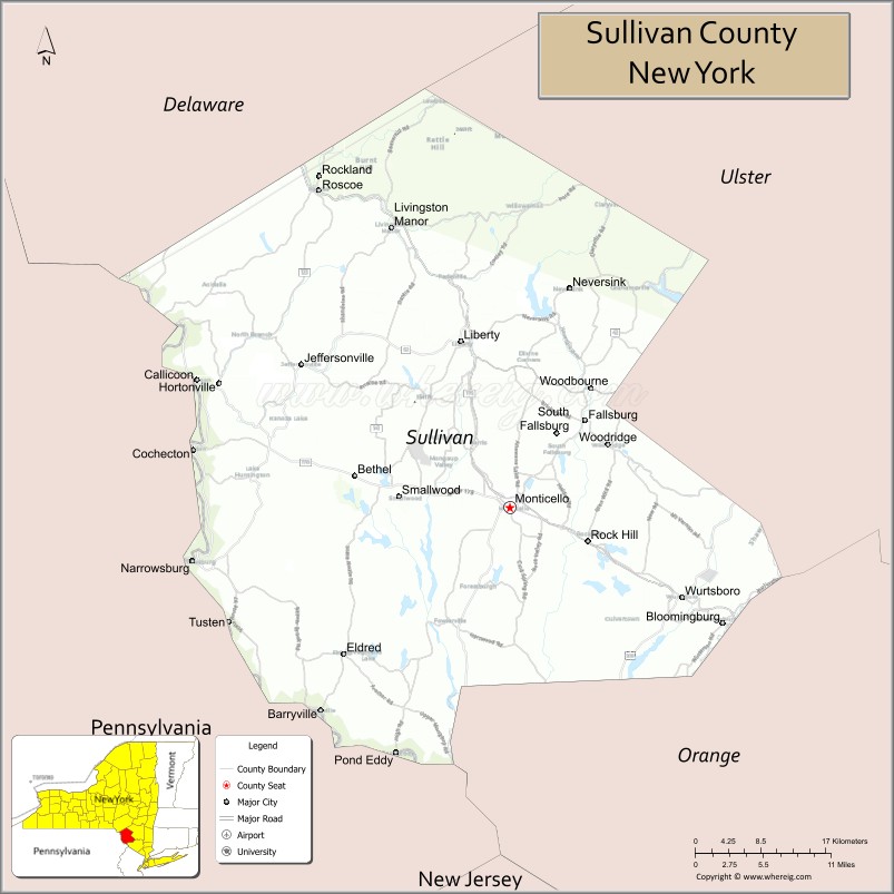
About Sullivan County Map, New York: The map showing the county boundary, county seat, major cities, highways, water bodies and neighbouring counties.
Related NY Maps & Info
About Sullivan County, New York
Sullivan County is a county located in the U.S. state of New York. It's county seat is Monticello. As per 2020 census, the population of Sullivan County is 79806 people and population density is 80.05 square miles. According to the United States Census Bureau, the county has a total area of 997 sq mi (2,582 km2). Sullivan County was established on 1809.
Facts about Sullivan County, New York
| Country | United States |
| State | New York |
| Region | Hudson Valley / Catskills (Northern & Southern NY) |
| County Seat | Monticello |
| Founded | 1809 |
| Named For | Major General John Sullivan (Revolutionary War officer) |
| Coordinates | 41.72° N, 74.77° W |
| Total Area | 997 sq mi |
| Land Area | 968 sq mi |
| Water Area | 29 sq mi |
| Water % | 2.9% |
| Population (2020) | 78,624 |
| Estimated Population (2024) | 80,450 |
| Population Density | 83/sq mi |
| Largest Municipality | Monticello (village) |
| Other Towns & Communities | Liberty, Fallsburg, Bethel, Neversink, Rock Hill, Callicoon |
| Main Industries | Tourism & Hospitality, Recreation, Agriculture, Services |
| Major Highways | NY‑17 (Future I‑86), U.S. 209, NY‑52, NY‑55 |
| Time Zone | Eastern Time (UTC−05:00) |
| Known For | Catskill scenery, Borscht Belt resort history, Bethel Woods Center for the Arts, outdoor activities |
| Website | https://sullivanny.us/ |
Top Attractions in Sullivan County, New York
- Bethel Woods Center for the Arts – Historic Woodstock festival site.
- Delaware River – Fishing and scenic river views.
- Catskill Mountains – Hiking and outdoor recreation.
- Resorts World Catskills – Casino and entertainment complex.
- Lake Superior State Park – Swimming and picnicking.
- Neversink River – Fishing and paddling.
- Mongaup Pond Campground – Camping and lake recreation.
- Forestburgh Playhouse – Summer theater performances.
- Callicoon Village – Riverfront shops and dining.
- Upper Delaware Scenic Byway – Scenic driving route.
- Sullivan County Museum – Local history exhibits.
- Minnewaska State Park Preserve (nearby) – Cliffs and hiking trails.
Cities & Towns in Sullivan County, New York
Monticello, Liberty, Fallsburg, Thompson, Rockland, Neversink, Forestburgh, Mamakating, Cochecton, Bethel, Callicoon, Highland, Lumberland, Fremont, Tusten, Delaware, Hancock
- Albany County Map
- Allegany County Map
- Bronx County Map
- Broome County Map
- Cattaraugus County Map
- Cayuga County Map
- Chautauqua County Map
- Chemung County Map
- Chenango County Map
- Clinton County Map
- Columbia County Map
- Cortland County Map
- Delaware County Map
- Dutchess County Map
- Erie County Map
- Essex County Map
- Franklin County Map
- Fulton County Map
- Genesee County Map
- Greene County Map
- Hamilton County Map
- Herkimer County Map
- Jefferson County Map
- Kings County Map
- Lewis County Map
- Livingston County Map
- Madison County Map
- Monroe County Map
- Montgomery County Map
- Nassau County Map
- New York County Map
- Niagara County Map
- Oneida County Map
- Onondaga County Map
- Ontario County Map
- Orange County Map
- Orleans County Map
- Oswego County Map
- Otsego County Map
- Putnam County Map
- Queens County Map
- Rensselaer County Map
- Richmond County Map
- Rockland County Map
- St Lawrence County Map
- Saratoga County Map
- Schenectady County Map
- Schoharie County Map
- Schuyler County Map
- Seneca County Map
- Steuben County Map
- Suffolk County Map
- Sullivan County Map
- Tioga County Map
- Tompkins County Map
- Ulster County Map
- Warren County Map
- Washington County Map
- Wayne County Map
- Westchester County Map
- Wyoming County Map
- Yates County Map
- Alabama Counties
- Alaska boroughs
- Arizona Counties
- Arkansas Counties
- California County Map
- Colorado Counties
- Connecticut Counties
- Delaware Counties
- Florida County Map
- Georgia County Map
- Hawaii Counties
- Idaho Counties
- Illinois Counties
- Indiana Counties
- Iowa Counties
- Kansas Counties
- Kentucky Counties
- Louisiana Counties
- Maine Counties
- Maryland Counties
- Massachusetts Counties
- Michigan County Map
- Minnesota Counties
- Mississippi Counties
- Missouri Counties
- Montana Counties
- Nebraska Counties
- Nevada Counties
- New York Counties
- New Hampshire Counties
- New Jersey Counties
- New Mexico Counties
- North Carolina Counties
- North Dakota Counties
- Ohio County Map
- Oklahoma Counties
- Oregon Counties
- Pennsylvania Counties
- Rhode Island Counties
- South Carolina Counties
- South Dakota Counties
- Map of Tennessee
- Texas County Map
- Utah Counties
- Vermont Counties
- Virginia Counties
- Washington Counties
- West Virginia Counties
- Wisconsin Counties
- Wyoming Counties