Written and Fact-checked by Mukesh Kumar | Updated On: April 256 2026 | 15:50 ET
Map of Chautauqua County - Chautauqua County is a county located in the U.S. state of New York. Chautauqua County Map showing cities, highways, important places and water bodies. Get Where is Chautauqua County located in the map, major cities in Chautauqua county, population, areas, and places of interest.
Map of Chautauqua County, New York
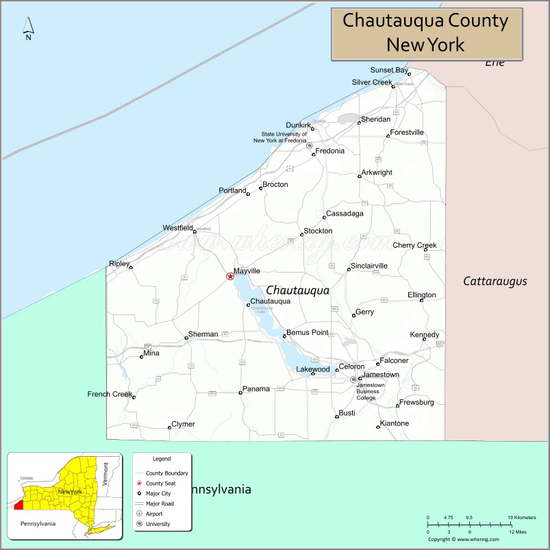
About Chautauqua County Map, New York: The map showing the county boundary, county seat, major cities, highways, water bodies and neighbouring counties.
Related NY Maps & Info
About Chautauqua County, New York
Chautauqua County is a county located in the U.S. state of New York. It's county seat is Mayville. As per 2020 census, the population of Chautauqua County is 126807 people and population density is 84.54 square miles. According to the United States Census Bureau, the county has a total area of 1,500 sq mi (3,885 km2). Chautauqua County was established on 1808.
Facts about Chautauqua County, New York
| Country | United States |
| State | New York |
| Region | Western New York / Southern Tier |
| County Seat | Mayville |
| Founded | 1808 (organized Feb 9, 1811) |
| Named For | Chautauqua Lake (Seneca/Iroquoian origin) |
| Coordinates | 42.25° N, 79.31° W |
| Total Area | 1,500 sq mi |
| Land Area | 1,060 sq mi |
| Water Area | 440 sq mi |
| Water % | 29% |
| Population (2020) | 127,657 |
| Estimated Population (2024) | 124,100 |
| Population Density | 117/sq mi |
| Largest City | Jamestown |
| Other Communities | Dunkirk, Fredonia, Westfield, Lakewood, Silver Creek |
| Main Industries | Manufacturing, Agriculture, Tourism, Services |
| Major Highways | I‑86, I‑90, U.S. 20, NY‑5, NY‑60 |
| Time Zone | Eastern Time (UTC−05:00) |
| Known For | Chautauqua Lake & Institution, Lake Erie shoreline, outdoor recreation |
| Website | https://www.co.chautauqua.ny.us/ |
Top Attractions in Chautauqua County, New York
- Chautauqua Institution – Cultural center with lectures and arts.
- Chautauqua Lake – Boating, fishing, and recreation.
- National Comedy Center – Interactive comedy museum.
- Lucille Ball Desi Arnaz Museum – Museum honoring TV legends.
- Midway State Park – Amusement rides and lake views.
- Panama Rocks Scenic Park – Ancient rock formations and trails.
- Barcelona Lighthouse – Historic Lake Erie lighthouse.
- Erie Lakefront Parks – Beaches and waterfront access.
- Peek’n Peak Resort – Skiing and golf resort.
- Audubon Community Nature Center – Nature trails and education.
- Westfield Covered Bridge – Historic covered bridge.
- Long Point State Park – Picnic areas and lake access.
Cities & Towns in Chautauqua County, New York
Jamestown, Dunkirk, Fredonia, Lakewood, Westfield, Mayville, Silver Creek, Panama, Forestville, Sherman, Sinclairville, Cherry Creek, Cassadaga, Brocton, Clymer, South Dayton, Kiantone, Ellery, Gerry, Arkwright
- Albany County Map
- Allegany County Map
- Bronx County Map
- Broome County Map
- Cattaraugus County Map
- Cayuga County Map
- Chautauqua County Map
- Chemung County Map
- Chenango County Map
- Clinton County Map
- Columbia County Map
- Cortland County Map
- Delaware County Map
- Dutchess County Map
- Erie County Map
- Essex County Map
- Franklin County Map
- Fulton County Map
- Genesee County Map
- Greene County Map
- Hamilton County Map
- Herkimer County Map
- Jefferson County Map
- Kings County Map
- Lewis County Map
- Livingston County Map
- Madison County Map
- Monroe County Map
- Montgomery County Map
- Nassau County Map
- New York County Map
- Niagara County Map
- Oneida County Map
- Onondaga County Map
- Ontario County Map
- Orange County Map
- Orleans County Map
- Oswego County Map
- Otsego County Map
- Putnam County Map
- Queens County Map
- Rensselaer County Map
- Richmond County Map
- Rockland County Map
- St Lawrence County Map
- Saratoga County Map
- Schenectady County Map
- Schoharie County Map
- Schuyler County Map
- Seneca County Map
- Steuben County Map
- Suffolk County Map
- Sullivan County Map
- Tioga County Map
- Tompkins County Map
- Ulster County Map
- Warren County Map
- Washington County Map
- Wayne County Map
- Westchester County Map
- Wyoming County Map
- Yates County Map
- Alabama Counties
- Alaska boroughs
- Arizona Counties
- Arkansas Counties
- California County Map
- Colorado Counties
- Connecticut Counties
- Delaware Counties
- Florida County Map
- Georgia County Map
- Hawaii Counties
- Idaho Counties
- Illinois Counties
- Indiana Counties
- Iowa Counties
- Kansas Counties
- Kentucky Counties
- Louisiana Counties
- Maine Counties
- Maryland Counties
- Massachusetts Counties
- Michigan County Map
- Minnesota Counties
- Mississippi Counties
- Missouri Counties
- Montana Counties
- Nebraska Counties
- Nevada Counties
- New York Counties
- New Hampshire Counties
- New Jersey Counties
- New Mexico Counties
- North Carolina Counties
- North Dakota Counties
- Ohio County Map
- Oklahoma Counties
- Oregon Counties
- Pennsylvania Counties
- Rhode Island Counties
- South Carolina Counties
- South Dakota Counties
- Map of Tennessee
- Texas County Map
- Utah Counties
- Vermont Counties
- Virginia Counties
- Washington Counties
- West Virginia Counties
- Wisconsin Counties
- Wyoming Counties