Written and Fact-checked by Mukesh Kumar | Updated On: April 256 2026 | 15:50 ET
Map of Saratoga County - Saratoga County is a county located in the U.S. state of New York. Saratoga County Map showing cities, highways, important places and water bodies. Get Where is Saratoga County located in the map, major cities in Saratoga county, population, areas, and places of interest.
Map of Saratoga County, New York
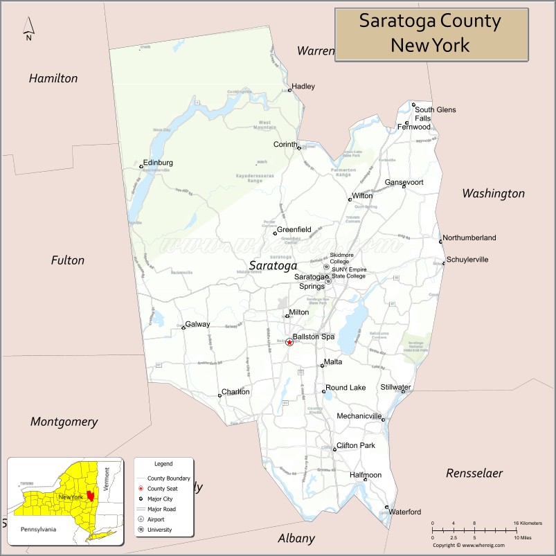
About Saratoga County Map, New York: The map showing the county boundary, county seat, major cities, highways, water bodies and neighbouring counties.
Related NY Maps & Info
About Saratoga County, New York
Saratoga County is a county located in the U.S. state of New York. It's county seat is Ballston Spa. As per 2020 census, the population of Saratoga County is 237359 people and population density is 281.23 square miles. According to the United States Census Bureau, the county has a total area of 844 sq mi (2,186 km2). Saratoga County was established on 1791.
Facts about Saratoga County, New York
| Country | United States |
| State | New York |
| Region | Capital District / Eastern New York |
| County Seat | Ballston Spa |
| Founded | 1791 |
| Named For | Iroquoian word *Sah‑rah‑ka* or *Sarach‑to‑ga* (meaning related to rapid water or “hill beside the river”) |
| Coordinates | 43.00° N, 73.65° W |
| Total Area | 822 sq mi |
| Land Area | 800 sq mi |
| Water Area | 22 sq mi |
| Water % | 2.7% |
| Population (2020) | 235,509 |
| Estimated Population (2024) | 240,360 (FRED estimate) |
| Population Density | 294/sq mi |
| Largest Municipality | Clifton Park (town) |
| Other Cities & Towns | Saratoga Springs, Mechanicville, Stillwater, Malta, Greenfield |
| Main Industries | Tourism, Services, High‑Tech Manufacturing, Healthcare, Education |
| Major Highways | I‑87 (Adirondack Northway), U.S. 9, NY‑29, NY‑50, NY‑9N |
| Time Zone | Eastern Time (UTC−05:00) |
| Known For | Saratoga Race Course, Saratoga National Historical Park (Battle of Saratoga), mineral springs & spa history, Saratoga Performing Arts Center |
| Website | https://www.saratogacountyny.gov/ |
Top Attractions in Saratoga County, New York
- Saratoga Race Course – Historic thoroughbred racetrack.
- Saratoga Spa State Park – Mineral springs and trails.
- Saratoga Performing Arts Center – Outdoor concerts and ballet.
- Saratoga National Historical Park – Revolutionary War battlefield.
- Saratoga Automobile Museum – Classic and modern cars.
- Congress Park – Downtown park and fountains.
- Skidmore College Campus – Arts and academic setting.
- Yaddo Gardens – Formal gardens and estate.
- Saratoga Lake – Boating and lakeside recreation.
- Round Lake Village – Historic lakeside community.
- Moreau Lake State Park – Camping and hiking.
- Brookside Museum – Local history exhibits.
Cities & Towns in Saratoga County, New York
Saratoga Springs, Ballston Spa, Mechanicville, Clifton Park, Stillwater, Wilton, Malta, Milton, Schuylerville, Corinth, Greenfield, Northumberland, Hadley, Moreau, Day, Edinburg, Providence, Galway, Benson, Charlton
- Albany County Map
- Allegany County Map
- Bronx County Map
- Broome County Map
- Cattaraugus County Map
- Cayuga County Map
- Chautauqua County Map
- Chemung County Map
- Chenango County Map
- Clinton County Map
- Columbia County Map
- Cortland County Map
- Delaware County Map
- Dutchess County Map
- Erie County Map
- Essex County Map
- Franklin County Map
- Fulton County Map
- Genesee County Map
- Greene County Map
- Hamilton County Map
- Herkimer County Map
- Jefferson County Map
- Kings County Map
- Lewis County Map
- Livingston County Map
- Madison County Map
- Monroe County Map
- Montgomery County Map
- Nassau County Map
- New York County Map
- Niagara County Map
- Oneida County Map
- Onondaga County Map
- Ontario County Map
- Orange County Map
- Orleans County Map
- Oswego County Map
- Otsego County Map
- Putnam County Map
- Queens County Map
- Rensselaer County Map
- Richmond County Map
- Rockland County Map
- St Lawrence County Map
- Saratoga County Map
- Schenectady County Map
- Schoharie County Map
- Schuyler County Map
- Seneca County Map
- Steuben County Map
- Suffolk County Map
- Sullivan County Map
- Tioga County Map
- Tompkins County Map
- Ulster County Map
- Warren County Map
- Washington County Map
- Wayne County Map
- Westchester County Map
- Wyoming County Map
- Yates County Map
- Alabama Counties
- Alaska boroughs
- Arizona Counties
- Arkansas Counties
- California County Map
- Colorado Counties
- Connecticut Counties
- Delaware Counties
- Florida County Map
- Georgia County Map
- Hawaii Counties
- Idaho Counties
- Illinois Counties
- Indiana Counties
- Iowa Counties
- Kansas Counties
- Kentucky Counties
- Louisiana Counties
- Maine Counties
- Maryland Counties
- Massachusetts Counties
- Michigan County Map
- Minnesota Counties
- Mississippi Counties
- Missouri Counties
- Montana Counties
- Nebraska Counties
- Nevada Counties
- New York Counties
- New Hampshire Counties
- New Jersey Counties
- New Mexico Counties
- North Carolina Counties
- North Dakota Counties
- Ohio County Map
- Oklahoma Counties
- Oregon Counties
- Pennsylvania Counties
- Rhode Island Counties
- South Carolina Counties
- South Dakota Counties
- Map of Tennessee
- Texas County Map
- Utah Counties
- Vermont Counties
- Virginia Counties
- Washington Counties
- West Virginia Counties
- Wisconsin Counties
- Wyoming Counties