Written and Fact-checked by Mukesh Kumar | Updated On: April 256 2026 | 15:50 ET
Map of Westchester County - Westchester County is a county located in the U.S. state of New York. Westchester County Map showing cities, highways, important places and water bodies. Get Where is Westchester County located in the map, major cities in Westchester county, population, areas, and places of interest.
Map of Westchester County, New York
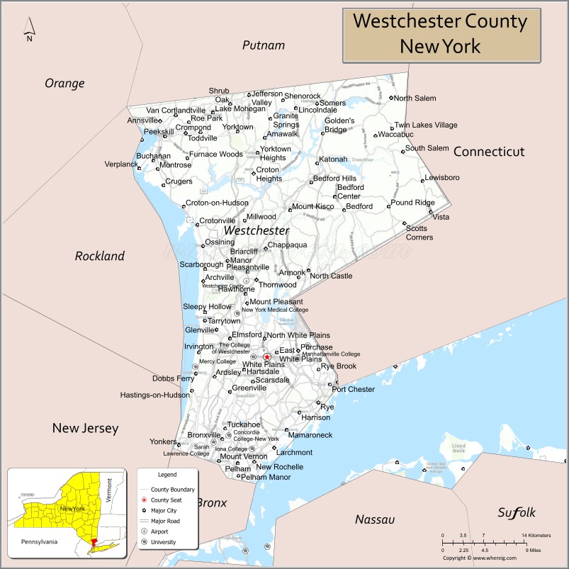
About Westchester County Map, New York: The map showing the county boundary, county seat, major cities, highways, water bodies and neighbouring counties.
Related NY Maps & Info
About Westchester County, New York
Westchester County is a county located in the U.S. state of New York. It's county seat is White Plains. As per 2020 census, the population of Westchester County is 997895 people and population density is 1995.79 square miles. According to the United States Census Bureau, the county has a total area of 500 sq mi (1,295 km2). Westchester County was established on 1683.
Facts about Westchester County, New York
| Country | United States |
| State | New York |
| Region | Hudson Valley / Southeastern New York |
| County Seat | White Plains |
| Founded | 1683 |
| Named For | Chester, England (as in “West Chester” west of other Chester‑named places) |
| Coordinates | 41.18° N, 73.75° W |
| Total Area | 450 sq mi |
| Land Area | 430 sq mi |
| Water Area | 20 sq mi |
| Water % | 4.4% |
| Population (2020) | 1,004,456 |
| Estimated Population (2024) | 990,000 – 1,000,000+ |
| Population Density | 2,300/sq mi (land area) |
| Largest Municipality | Yonkers |
| Other Cities & Towns | New Rochelle, Mount Vernon, White Plains, Peekskill, Greenburgh, Ossining, Yorktown |
| Main Industries | Services, Healthcare, Education, Finance, Technology, Retail |
| Major Highways | I‑87 (Major Deegan/Northway), I‑287, I‑95, I‑684, Hutchinson River Pkwy |
| Time Zone | Eastern Time (UTC−05:00) |
| Known For | Proximity to NYC, Hudson River & Long Island Sound shorelines, historic sites, affluent suburbs |
| Website | https://www.westchestergov.com/ |
Cities & Towns in Westchester County, New York
White Plains, Yonkers, New Rochelle, Mount Vernon, Peekskill, Ossining, Tarrytown, Rye, Scarsdale, Hastings-on-Hudson, Dobbs Ferry, Port Chester, Sleepy Hollow, Croton-on-Hudson, Irvington, Ardsley, Elmsford, Briarcliff Manor, Harrison, Greenburgh
- Albany County Map
- Allegany County Map
- Bronx County Map
- Broome County Map
- Cattaraugus County Map
- Cayuga County Map
- Chautauqua County Map
- Chemung County Map
- Chenango County Map
- Clinton County Map
- Columbia County Map
- Cortland County Map
- Delaware County Map
- Dutchess County Map
- Erie County Map
- Essex County Map
- Franklin County Map
- Fulton County Map
- Genesee County Map
- Greene County Map
- Hamilton County Map
- Herkimer County Map
- Jefferson County Map
- Kings County Map
- Lewis County Map
- Livingston County Map
- Madison County Map
- Monroe County Map
- Montgomery County Map
- Nassau County Map
- New York County Map
- Niagara County Map
- Oneida County Map
- Onondaga County Map
- Ontario County Map
- Orange County Map
- Orleans County Map
- Oswego County Map
- Otsego County Map
- Putnam County Map
- Queens County Map
- Rensselaer County Map
- Richmond County Map
- Rockland County Map
- St Lawrence County Map
- Saratoga County Map
- Schenectady County Map
- Schoharie County Map
- Schuyler County Map
- Seneca County Map
- Steuben County Map
- Suffolk County Map
- Sullivan County Map
- Tioga County Map
- Tompkins County Map
- Ulster County Map
- Warren County Map
- Washington County Map
- Wayne County Map
- Westchester County Map
- Wyoming County Map
- Yates County Map
- Alabama Counties
- Alaska boroughs
- Arizona Counties
- Arkansas Counties
- California County Map
- Colorado Counties
- Connecticut Counties
- Delaware Counties
- Florida County Map
- Georgia County Map
- Hawaii Counties
- Idaho Counties
- Illinois Counties
- Indiana Counties
- Iowa Counties
- Kansas Counties
- Kentucky Counties
- Louisiana Counties
- Maine Counties
- Maryland Counties
- Massachusetts Counties
- Michigan County Map
- Minnesota Counties
- Mississippi Counties
- Missouri Counties
- Montana Counties
- Nebraska Counties
- Nevada Counties
- New York Counties
- New Hampshire Counties
- New Jersey Counties
- New Mexico Counties
- North Carolina Counties
- North Dakota Counties
- Ohio County Map
- Oklahoma Counties
- Oregon Counties
- Pennsylvania Counties
- Rhode Island Counties
- South Carolina Counties
- South Dakota Counties
- Map of Tennessee
- Texas County Map
- Utah Counties
- Vermont Counties
- Virginia Counties
- Washington Counties
- West Virginia Counties
- Wisconsin Counties
- Wyoming Counties