Written and Fact-checked by Mukesh Kumar | Updated On: April 256 2026 | 15:50 ET
Map of Dutchess County - Dutchess County is a county located in the U.S. state of New York. Dutchess County Map showing cities, highways, important places and water bodies. Get Where is Dutchess County located in the map, major cities in Dutchess county, population, areas, and places of interest.
Map of Dutchess County, New York
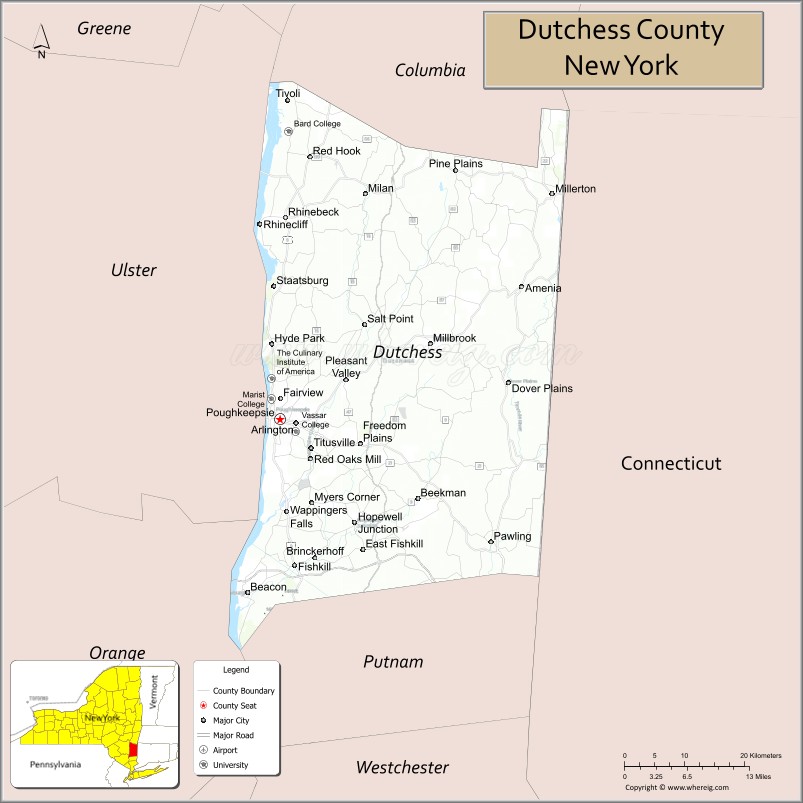
About Dutchess County Map, New York: The map showing the county boundary, county seat, major cities, highways, water bodies and neighbouring counties.
Related NY Maps & Info
About Dutchess County, New York
Dutchess County is a county located in the U.S. state of New York. It's county seat is Poughkeepsie. As per 2020 census, the population of Dutchess County is 297112 people and population density is 360.14 square miles. According to the United States Census Bureau, the county has a total area of 825 sq mi (2,137 km2). Dutchess County was established on 1683.
Facts about Dutchess County, New York
| Country | United States |
| State | New York |
| Region | Hudson Valley / Southeastern New York |
| County Seat | Poughkeepsie |
| Founded | November 1, 1683 |
| Organized | 1713 |
| Named For | Mary of Modena, Duchess of York (archaic “Dutchess” spelling) |
| Coordinates | 41.70° N, 73.92° W |
| Total Area | 825 sq mi |
| Land Area | 796 sq mi |
| Water Area | 30 sq mi |
| Water % | 3.6% |
| Population (2020) | 295,911 |
| Estimated Population (2024) | 297,112+ |
| Population Density | 372/sq mi |
| Largest City | Poughkeepsie |
| Other Cities & Towns | Beacon, Hyde Park, Rhinebeck, Fishkill, Wappingers Falls, East Fishkill |
| Main Industries | Services, Tourism, Education, Healthcare, Commuter‑based economy |
| Major Highways | I‑84, U.S. 9, NY‑9D, NY‑22, NY‑55 |
| Time Zone | Eastern Time (UTC−05:00) |
| Known For | Hudson River Valley scenery, historic sites (FDR & Vanderbilt estates), Dutchess County Fair |
| Website | https://www.dutchessny.gov/ |
Top Attractions in Dutchess County, New York
- Vanderbilt Mansion National Historic Site – Gilded Age riverfront estate.
- Home of Franklin D. Roosevelt National Historic Site – Presidential home and museum.
- Walkway Over the Hudson – Elevated pedestrian bridge.
- Culinary Institute of America – Renowned culinary school and dining.
- Dia Beacon – Contemporary art museum.
- Locust Grove Estate – Historic mansion and gardens.
- Bowdoin Park – Riverfront park and trails.
- Mills-Norrie State Park – Hudson River views and camping.
- Hudson River Maritime Museum – River and maritime history.
- Fishkill Farms – Seasonal farm activities.
- Staatsburgh State Historic Site – Gilded Age estate.
- Millbrook Village – Quaint shops and countryside.
Cities & Towns in Dutchess County, New York
Poughkeepsie, Beacon, Rhinebeck, Fishkill, Hyde Park, Wappingers Falls, Millbrook, Red Hook, Dover Plains, Pawling, Amenia, La Grange, Pleasant Valley, Union Vale, Tivoli, Staatsburg, Millerton, North East, Pleasant Plains
- Albany County Map
- Allegany County Map
- Bronx County Map
- Broome County Map
- Cattaraugus County Map
- Cayuga County Map
- Chautauqua County Map
- Chemung County Map
- Chenango County Map
- Clinton County Map
- Columbia County Map
- Cortland County Map
- Delaware County Map
- Dutchess County Map
- Erie County Map
- Essex County Map
- Franklin County Map
- Fulton County Map
- Genesee County Map
- Greene County Map
- Hamilton County Map
- Herkimer County Map
- Jefferson County Map
- Kings County Map
- Lewis County Map
- Livingston County Map
- Madison County Map
- Monroe County Map
- Montgomery County Map
- Nassau County Map
- New York County Map
- Niagara County Map
- Oneida County Map
- Onondaga County Map
- Ontario County Map
- Orange County Map
- Orleans County Map
- Oswego County Map
- Otsego County Map
- Putnam County Map
- Queens County Map
- Rensselaer County Map
- Richmond County Map
- Rockland County Map
- St Lawrence County Map
- Saratoga County Map
- Schenectady County Map
- Schoharie County Map
- Schuyler County Map
- Seneca County Map
- Steuben County Map
- Suffolk County Map
- Sullivan County Map
- Tioga County Map
- Tompkins County Map
- Ulster County Map
- Warren County Map
- Washington County Map
- Wayne County Map
- Westchester County Map
- Wyoming County Map
- Yates County Map
- Alabama Counties
- Alaska boroughs
- Arizona Counties
- Arkansas Counties
- California County Map
- Colorado Counties
- Connecticut Counties
- Delaware Counties
- Florida County Map
- Georgia County Map
- Hawaii Counties
- Idaho Counties
- Illinois Counties
- Indiana Counties
- Iowa Counties
- Kansas Counties
- Kentucky Counties
- Louisiana Counties
- Maine Counties
- Maryland Counties
- Massachusetts Counties
- Michigan County Map
- Minnesota Counties
- Mississippi Counties
- Missouri Counties
- Montana Counties
- Nebraska Counties
- Nevada Counties
- New York Counties
- New Hampshire Counties
- New Jersey Counties
- New Mexico Counties
- North Carolina Counties
- North Dakota Counties
- Ohio County Map
- Oklahoma Counties
- Oregon Counties
- Pennsylvania Counties
- Rhode Island Counties
- South Carolina Counties
- South Dakota Counties
- Map of Tennessee
- Texas County Map
- Utah Counties
- Vermont Counties
- Virginia Counties
- Washington Counties
- West Virginia Counties
- Wisconsin Counties
- Wyoming Counties