Written and Fact-checked by Mukesh Kumar | Updated On: April 256 2026 | 15:50 ET
Written and Fact-checked by Mukesh Kumar | Updated On: April 256 2026 | 15:50 ET
Map of Cattaraugus County - Cattaraugus County is a county located in the U.S. state of New York. Cattaraugus County Map showing cities, highways, important places and water bodies. Get Where is Cattaraugus County located in the map, major cities in Cattaraugus county, population, areas, and places of interest.
Map of Cattaraugus County, New York
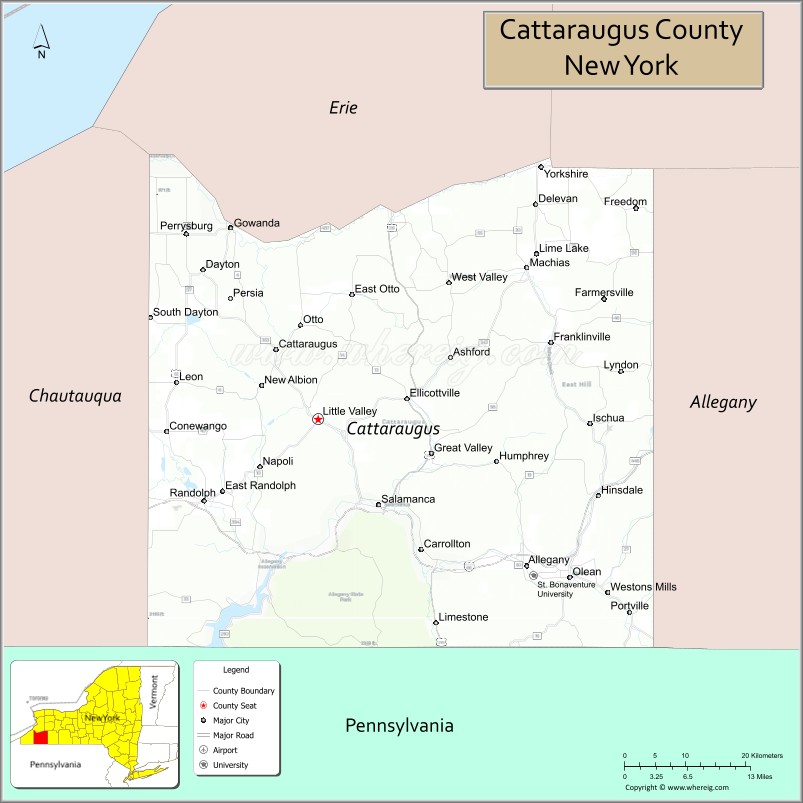
About Cattaraugus County Map, New York: The map showing the county boundary, county seat, major cities, highways, water bodies and neighbouring counties.
Related NY Maps & Info
About Cattaraugus County, New York
Cattaraugus County is a county located in the U.S. state of New York. It's county seat is Little Valley. As per 2020 census, the population of Cattaraugus County is 76426 people and population density is 58.34 square miles. According to the United States Census Bureau, the county has a total area of 1,310 sq mi (3,393 km2). Cattaraugus County was established on 1808.
Facts about Cattaraugus County, New York
| Country | United States |
| State | New York |
| Region | Western New York / Southern Tier |
| County Seat | Little Valley |
| Founded | March 28, 1817 (organized; formed 1808) |
| Named For | Seneca word “Cattaraugus” (meaning “bad‑smelling banks” referring to natural gas seeps) |
| Coordinates | 42.24° N, 78.64° W |
| Total Area | 1,322 sq mi |
| Land Area | 1,308 sq mi |
| Water Area | 14 sq mi |
| Water % | 1.1% |
| Population (2020) | 77,042 |
| Estimated Population (2024) | 75,475 |
| Population Density | 58/sq mi |
| Largest City | Olean |
| Other Cities & Towns | Salamanca, Ellicottville, Franklinville, Allegany, Ashford |
| Main Industries | Manufacturing, Agriculture, Services, Tourism (skiing, outdoor recreation) |
| Major Highways | I‑86/NY‑17, U.S. 219, U.S. 62, NY 16, NY 98, NY 242, NY 353, NY 417 |
| Time Zone | Eastern Time (UTC−05:00) |
| Known For | Enchanted Mountains, Allegheny River, Allegany State Park, Cattaraugus County Fair |
| Website | https://www.cattco.org/ |
Top Attractions in Cattaraugus County, New York
- Allegany State Park – Large park with trails and camping.
- Rock City Park – Massive ancient rock formations.
- Ellicottville Mountain Resort – Skiing and snowboarding destination.
- Seneca-Iroquois National Museum – Native American history and culture.
- Griffis Sculpture Park – Outdoor sculptures and hiking.
- HoliMont Ski Area – Private ski resort.
- Ellicottville Brewing Company – Local brewery and pub.
- Thunder Rocks – Large rock formations in forest.
- Cattaraugus County Museum – Local history museum.
- Zoar Valley Multiple Use Area – Scenic gorge and trails.
- Little Valley Courthouse – Historic county courthouse.
- Allegheny River – Fishing and canoeing river.
Cities & Towns in Cattaraugus County, New York
Olean, Salamanca, Little Valley, Cattaraugus, Allegany, Franklinville, Ellicottville, Gowanda, Hinsdale, South Dayton, Portville, Randolph, Delevan, Perrysburg, Farmersville, Carrollton, Dayton, Conewango
- Albany County Map
- Allegany County Map
- Bronx County Map
- Broome County Map
- Cattaraugus County Map
- Cayuga County Map
- Chautauqua County Map
- Chemung County Map
- Chenango County Map
- Clinton County Map
- Columbia County Map
- Cortland County Map
- Delaware County Map
- Dutchess County Map
- Erie County Map
- Essex County Map
- Franklin County Map
- Fulton County Map
- Genesee County Map
- Greene County Map
- Hamilton County Map
- Herkimer County Map
- Jefferson County Map
- Kings County Map
- Lewis County Map
- Livingston County Map
- Madison County Map
- Monroe County Map
- Montgomery County Map
- Nassau County Map
- New York County Map
- Niagara County Map
- Oneida County Map
- Onondaga County Map
- Ontario County Map
- Orange County Map
- Orleans County Map
- Oswego County Map
- Otsego County Map
- Putnam County Map
- Queens County Map
- Rensselaer County Map
- Richmond County Map
- Rockland County Map
- St Lawrence County Map
- Saratoga County Map
- Schenectady County Map
- Schoharie County Map
- Schuyler County Map
- Seneca County Map
- Steuben County Map
- Suffolk County Map
- Sullivan County Map
- Tioga County Map
- Tompkins County Map
- Ulster County Map
- Warren County Map
- Washington County Map
- Wayne County Map
- Westchester County Map
- Wyoming County Map
- Yates County Map
- Alabama Counties
- Alaska boroughs
- Arizona Counties
- Arkansas Counties
- California County Map
- Colorado Counties
- Connecticut Counties
- Delaware Counties
- Florida County Map
- Georgia County Map
- Hawaii Counties
- Idaho Counties
- Illinois Counties
- Indiana Counties
- Iowa Counties
- Kansas Counties
- Kentucky Counties
- Louisiana Counties
- Maine Counties
- Maryland Counties
- Massachusetts Counties
- Michigan County Map
- Minnesota Counties
- Mississippi Counties
- Missouri Counties
- Montana Counties
- Nebraska Counties
- Nevada Counties
- New York Counties
- New Hampshire Counties
- New Jersey Counties
- New Mexico Counties
- North Carolina Counties
- North Dakota Counties
- Ohio County Map
- Oklahoma Counties
- Oregon Counties
- Pennsylvania Counties
- Rhode Island Counties
- South Carolina Counties
- South Dakota Counties
- Map of Tennessee
- Texas County Map
- Utah Counties
- Vermont Counties
- Virginia Counties
- Washington Counties
- West Virginia Counties
- Wisconsin Counties
- Wyoming Counties