Written and Fact-checked by Mukesh Kumar | Updated On: April 256 2026 | 15:50 ET
Map of Suffolk County - Suffolk County is a county located in the U.S. state of New York. Suffolk County Map showing cities, highways, important places and water bodies. Get Where is Suffolk County located in the map, major cities in Suffolk county, population, areas, and places of interest.
Map of Suffolk County, New York
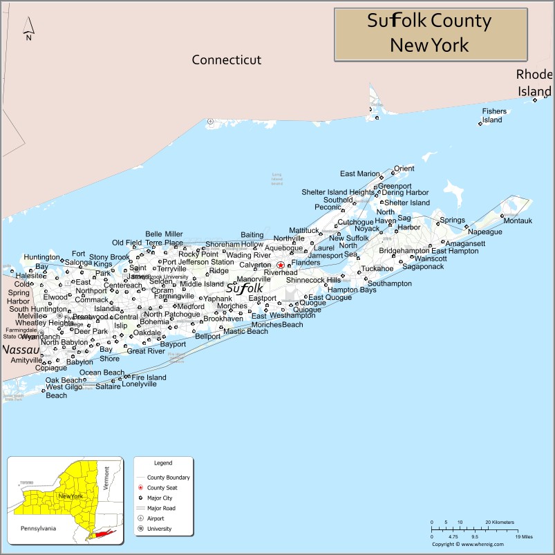
About Suffolk County Map, New York: The map showing the county boundary, county seat, major cities, highways, water bodies and neighbouring counties.
Related NY Maps & Info
About Suffolk County, New York
Wayne County is a county located in the U.S. state of New York. It`s county seat is Lyons. As per 2020 census, the population of Wayne County was 90923 and population density of Wayne was 65.7square miles. According to the United States Census Bureau, the county has a total area of 1,384 sq mi (3,585 km2). Wayne County was established on 1823.
Facts about Suffolk County, New York
| Country | United States |
| State | New York |
| Region | Long Island / Southeastern New York |
| County Seat | Riverhead |
| Founded | 1683 |
| Named For | Suffolk, England |
| Coordinates | 40.90° N, 72.67° W |
| Total Area | 2,373 sq mi |
| Land Area | 912 sq mi |
| Water Area | 1,461 sq mi |
| Water % | 62% |
| Population (2020) | 1,525,920 |
| Estimated Population (2024) | 1,535,909 |
| Population Density | 1,673/sq mi (land area) |
| Largest Municipality | Brookhaven (town) |
| Other Towns & Communities | Babylon, Huntington, Islip, Smithtown, Southampton, East Hampton, Southold, Shelter Island |
| Main Industries | Services, Technology, Education, Healthcare, Agriculture & Tourism |
| Major Highways | I‑495, NY‑27, NY‑25, Sunrise Hwy, Montauk Hwy |
| Time Zone | Eastern Time (UTC−05:00) |
| Known For | Beaches & coastline, Hamptons & North Fork wine country, Brookhaven National Lab, suburban & coastal lifestyle |
| Website | https://www.suffolkcountyny.gov/ |
Top Attractions in Suffolk County, New York
- Montauk Point Lighthouse – Iconic lighthouse and views.
- Fire Island National Seashore – Beaches and dunes.
- Long Island Wine Country – Vineyards and tastings.
- Stony Brook Village Green – Historic harbor village.
- Splish Splash Water Park – Large family water park.
- Sunken Meadow State Park – Coastal trails and scenery.
- Caumsett State Historic Park Preserve – Estate and waterfront trails.
- Brookhaven National Laboratory (visitor center) – Science exhibits.
- Port Jefferson Village – Harbor views and dining.
- Orient Beach State Park – North Fork shoreline park.
- Connetquot River State Park Preserve – Nature trails and fishing.
- Long Island Aquarium – Marine exhibits and shows.
Cities & Towns in Suffolk County, New York
Huntington, Babylon, Brookhaven, Islip, Smithtown, Riverhead, Southampton, Southold, East Hampton, Patchogue, Riverhead, Huntington Station, West Babylon, Bay Shore, Ronkonkoma, Centereach, Commack, Holbrook, Selden, Miller Place
- Albany County Map
- Allegany County Map
- Bronx County Map
- Broome County Map
- Cattaraugus County Map
- Cayuga County Map
- Chautauqua County Map
- Chemung County Map
- Chenango County Map
- Clinton County Map
- Columbia County Map
- Cortland County Map
- Delaware County Map
- Dutchess County Map
- Erie County Map
- Essex County Map
- Franklin County Map
- Fulton County Map
- Genesee County Map
- Greene County Map
- Hamilton County Map
- Herkimer County Map
- Jefferson County Map
- Kings County Map
- Lewis County Map
- Livingston County Map
- Madison County Map
- Monroe County Map
- Montgomery County Map
- Nassau County Map
- New York County Map
- Niagara County Map
- Oneida County Map
- Onondaga County Map
- Ontario County Map
- Orange County Map
- Orleans County Map
- Oswego County Map
- Otsego County Map
- Putnam County Map
- Queens County Map
- Rensselaer County Map
- Richmond County Map
- Rockland County Map
- St Lawrence County Map
- Saratoga County Map
- Schenectady County Map
- Schoharie County Map
- Schuyler County Map
- Seneca County Map
- Steuben County Map
- Suffolk County Map
- Sullivan County Map
- Tioga County Map
- Tompkins County Map
- Ulster County Map
- Warren County Map
- Washington County Map
- Wayne County Map
- Westchester County Map
- Wyoming County Map
- Yates County Map
- Alabama Counties
- Alaska boroughs
- Arizona Counties
- Arkansas Counties
- California County Map
- Colorado Counties
- Connecticut Counties
- Delaware Counties
- Florida County Map
- Georgia County Map
- Hawaii Counties
- Idaho Counties
- Illinois Counties
- Indiana Counties
- Iowa Counties
- Kansas Counties
- Kentucky Counties
- Louisiana Counties
- Maine Counties
- Maryland Counties
- Massachusetts Counties
- Michigan County Map
- Minnesota Counties
- Mississippi Counties
- Missouri Counties
- Montana Counties
- Nebraska Counties
- Nevada Counties
- New York Counties
- New Hampshire Counties
- New Jersey Counties
- New Mexico Counties
- North Carolina Counties
- North Dakota Counties
- Ohio County Map
- Oklahoma Counties
- Oregon Counties
- Pennsylvania Counties
- Rhode Island Counties
- South Carolina Counties
- South Dakota Counties
- Map of Tennessee
- Texas County Map
- Utah Counties
- Vermont Counties
- Virginia Counties
- Washington Counties
- West Virginia Counties
- Wisconsin Counties
- Wyoming Counties