Written and Fact-checked by Mukesh Kumar | Updated On: April 256 2026 | 15:50 ET
Map of Tioga County - Tioga County is a county located in the U.S. state of New York. Tioga County Map showing cities, highways, important places and water bodies. Get Where is Tioga County located in the map, major cities in Tioga county, population, areas, and places of interest.
Map of Tioga County, New York
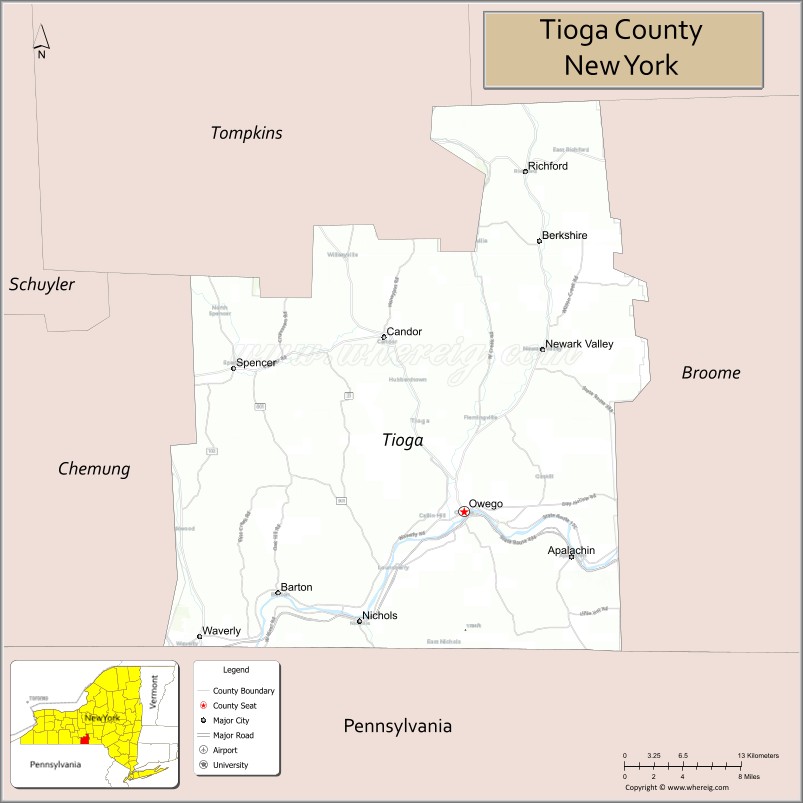
About Tioga County Map, New York: The map showing the county boundary, county seat, major cities, highways, water bodies and neighbouring counties.
Related NY Maps & Info
About Tioga County, New York
Tioga County is a county located in the U.S. state of New York. It's county seat is Owego. As per 2020 census, the population of Tioga County is 47980 people and population density is 91.74 square miles. According to the United States Census Bureau, the county has a total area of 523 sq mi (1,355 km2). Tioga County was established on 1791.
Facts about Tioga County, New York
| Country | United States |
| State | New York |
| Region | Southern Tier / Central New York |
| County Seat | Owego |
| Founded | 1791 |
| Named For | Iroquois word *De‑yoh‑ho‑gah* meaning “at the forks” or “where it forks” |
| Coordinates | 42.09° N, 76.47° W |
| Total Area | 523 sq mi |
| Land Area | 519 sq mi |
| Water Area | 4.3 sq mi |
| Water % | 0.8% |
| Population (2020) | 48,455 |
| Estimated Population (2024) | 47,900+ |
| Population Density | 93/sq mi |
| Largest Municipality | Waverly (village) |
| Other Towns & Communities | Barton, Berkshire, Candor, Newark Valley, Nichols, Owego, Richford, Spencer |
| Main Industries | Agriculture, Manufacturing, Services, Transportation |
| Major Highways | I‑86/NY‑17, NY‑96, NY‑38, NY‑96B |
| Time Zone | Eastern Time (UTC−05:00) |
| Known For | Susquehanna River valley, Southern Tier scenery, historic Owego village, rural character |
| Website | https://tiogacountyny.com/ |
Top Attractions in Tioga County, New York
- Hickories Park – Riverfront park and trails.
- Tioga Downs Casino Resort – Gaming and horse racing.
- Hiawatha Island Wildlife Refuge – Wetlands and birdwatching.
- Owego Historic District – Shops and 19th-century buildings.
- Hickories Museum – Local history exhibits.
- Waterman Conservation Education Center – Nature education and trails.
- Halsey Valley Ski Area – Skiing and winter sports.
- Tioga Central Railroad – Scenic train rides.
- Catatonk Golf Club – Golf and recreation.
- Apalachin Marsh Bird Sanctuary – Wildlife viewing area.
- Owego Riverwalk – Riverside walking path.
- Marshland Road Conservation Area – Nature trails.
Cities & Towns in Tioga County, New York
Owego, Waverly, Nichols, Candor, Newark Valley, Spencer, Berkshire, Richford, Tioga, Barton, Candor Center, Apalachin, Lockwood, Tioga Center, Lounsberry, Owego Center
- Albany County Map
- Allegany County Map
- Bronx County Map
- Broome County Map
- Cattaraugus County Map
- Cayuga County Map
- Chautauqua County Map
- Chemung County Map
- Chenango County Map
- Clinton County Map
- Columbia County Map
- Cortland County Map
- Delaware County Map
- Dutchess County Map
- Erie County Map
- Essex County Map
- Franklin County Map
- Fulton County Map
- Genesee County Map
- Greene County Map
- Hamilton County Map
- Herkimer County Map
- Jefferson County Map
- Kings County Map
- Lewis County Map
- Livingston County Map
- Madison County Map
- Monroe County Map
- Montgomery County Map
- Nassau County Map
- New York County Map
- Niagara County Map
- Oneida County Map
- Onondaga County Map
- Ontario County Map
- Orange County Map
- Orleans County Map
- Oswego County Map
- Otsego County Map
- Putnam County Map
- Queens County Map
- Rensselaer County Map
- Richmond County Map
- Rockland County Map
- St Lawrence County Map
- Saratoga County Map
- Schenectady County Map
- Schoharie County Map
- Schuyler County Map
- Seneca County Map
- Steuben County Map
- Suffolk County Map
- Sullivan County Map
- Tioga County Map
- Tompkins County Map
- Ulster County Map
- Warren County Map
- Washington County Map
- Wayne County Map
- Westchester County Map
- Wyoming County Map
- Yates County Map
- Alabama Counties
- Alaska boroughs
- Arizona Counties
- Arkansas Counties
- California County Map
- Colorado Counties
- Connecticut Counties
- Delaware Counties
- Florida County Map
- Georgia County Map
- Hawaii Counties
- Idaho Counties
- Illinois Counties
- Indiana Counties
- Iowa Counties
- Kansas Counties
- Kentucky Counties
- Louisiana Counties
- Maine Counties
- Maryland Counties
- Massachusetts Counties
- Michigan County Map
- Minnesota Counties
- Mississippi Counties
- Missouri Counties
- Montana Counties
- Nebraska Counties
- Nevada Counties
- New York Counties
- New Hampshire Counties
- New Jersey Counties
- New Mexico Counties
- North Carolina Counties
- North Dakota Counties
- Ohio County Map
- Oklahoma Counties
- Oregon Counties
- Pennsylvania Counties
- Rhode Island Counties
- South Carolina Counties
- South Dakota Counties
- Map of Tennessee
- Texas County Map
- Utah Counties
- Vermont Counties
- Virginia Counties
- Washington Counties
- West Virginia Counties
- Wisconsin Counties
- Wyoming Counties