Written and Fact-checked by Mukesh Kumar | Updated On: April 256 2026 | 15:50 ET
Map of Columbia County - Columbia County is a county located in the U.S. state of New York. Columbia County Map showing cities, highways, important places and water bodies. Get Where is Columbia County located in the map, major cities in Columbia county, population, areas, and places of interest.
Map of Columbia County, New York
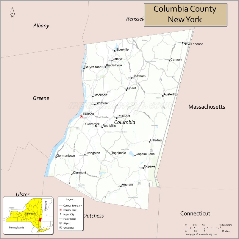
About Columbia County Map, New York: The map showing the county boundary, county seat, major cities, highways, water bodies and neighbouring counties.
Related NY Maps & Info
About Columbia County, New York
Columbia County is a county located in the U.S. state of New York. It's county seat is Hudson. As per 2020 census, the population of Columbia County is 61778 people and population density is 95.34 square miles. According to the United States Census Bureau, the county has a total area of 648 sq mi (1,678 km2). Columbia County was established on 1786.
Facts about Columbia County, New York
| Country | United States |
| State | New York |
| Region | Capital District / Upper Hudson Valley |
| County Seat | Hudson |
| Founded | April 4, 1786 |
| Named For | Columbia (Latin feminine form associated with Christopher Columbus) |
| Coordinates | 42.25° N, 73.63° W |
| Total Area | 648 sq mi |
| Land Area | 635 sq mi |
| Water Area | 14 sq mi |
| Water % | 2.1% |
| Population (2020) | 61,570 |
| Estimated Population (2024) | 61,245 |
| Population Density | 97/sq mi |
| Largest Municipality | Kinderhook (town) |
| Other Communities | Hudson, Chatham, Germantown, Claverack, Ghent, Taghkanic |
| Main Industries | Agriculture, Tourism, Arts & Culture, Services |
| Major Highways | I‑90, U.S. 9, NY‑9H, NY‑23, NY‑82 |
| Time Zone | Eastern Time (UTC−05:00) |
| Known For | Hudson River Valley scenery, historic architecture & villages, Olana State Historic Site, cultural attractions |
| Website | https://www.columbiacountyny.com/ |
Top Attractions in Columbia County, New York
- Olana State Historic Site – Frederic Church’s hilltop estate.
- Hudson Historic District – Antique shops and architecture.
- Hudson River Skywalk – Pedestrian bridge with views.
- Clermont State Historic Site – Livingston family estate.
- Thomas Cole National Historic Site – Hudson River School history.
- Taconic State Park – Trails and Bash Bish Falls.
- Art Omi – Outdoor sculpture park.
- Catamount Mountain Resort – Skiing and mountain biking.
- Hudson River Cruises – Scenic boat tours.
- Martin Van Buren National Historic Site – Presidential home.
- Chatham Village – Quaint downtown and shops.
- Harlem Valley Rail Trail – Walking and biking trail.
Cities & Towns in Columbia County, New York
Hudson, Chatham, Kinderhook, Ghent, Claverack, Austerlitz, Ancram, Copake, Stockport, Hillsdale, New Lebanon, Canaan, Stuyvesant, Taghkanic, Greenport
- Albany County Map
- Allegany County Map
- Bronx County Map
- Broome County Map
- Cattaraugus County Map
- Cayuga County Map
- Chautauqua County Map
- Chemung County Map
- Chenango County Map
- Clinton County Map
- Columbia County Map
- Cortland County Map
- Delaware County Map
- Dutchess County Map
- Erie County Map
- Essex County Map
- Franklin County Map
- Fulton County Map
- Genesee County Map
- Greene County Map
- Hamilton County Map
- Herkimer County Map
- Jefferson County Map
- Kings County Map
- Lewis County Map
- Livingston County Map
- Madison County Map
- Monroe County Map
- Montgomery County Map
- Nassau County Map
- New York County Map
- Niagara County Map
- Oneida County Map
- Onondaga County Map
- Ontario County Map
- Orange County Map
- Orleans County Map
- Oswego County Map
- Otsego County Map
- Putnam County Map
- Queens County Map
- Rensselaer County Map
- Richmond County Map
- Rockland County Map
- St Lawrence County Map
- Saratoga County Map
- Schenectady County Map
- Schoharie County Map
- Schuyler County Map
- Seneca County Map
- Steuben County Map
- Suffolk County Map
- Sullivan County Map
- Tioga County Map
- Tompkins County Map
- Ulster County Map
- Warren County Map
- Washington County Map
- Wayne County Map
- Westchester County Map
- Wyoming County Map
- Yates County Map
- Alabama Counties
- Alaska boroughs
- Arizona Counties
- Arkansas Counties
- California County Map
- Colorado Counties
- Connecticut Counties
- Delaware Counties
- Florida County Map
- Georgia County Map
- Hawaii Counties
- Idaho Counties
- Illinois Counties
- Indiana Counties
- Iowa Counties
- Kansas Counties
- Kentucky Counties
- Louisiana Counties
- Maine Counties
- Maryland Counties
- Massachusetts Counties
- Michigan County Map
- Minnesota Counties
- Mississippi Counties
- Missouri Counties
- Montana Counties
- Nebraska Counties
- Nevada Counties
- New York Counties
- New Hampshire Counties
- New Jersey Counties
- New Mexico Counties
- North Carolina Counties
- North Dakota Counties
- Ohio County Map
- Oklahoma Counties
- Oregon Counties
- Pennsylvania Counties
- Rhode Island Counties
- South Carolina Counties
- South Dakota Counties
- Map of Tennessee
- Texas County Map
- Utah Counties
- Vermont Counties
- Virginia Counties
- Washington Counties
- West Virginia Counties
- Wisconsin Counties
- Wyoming Counties