Written and Fact-checked by Mukesh Kumar | Updated On: April 256 2026 | 15:50 ET
Map of Ulster County - Ulster County is a county located in the U.S. state of New York. Ulster County Map showing cities, highways, important places and water bodies. Get Where is Ulster County located in the map, major cities in Ulster county, population, areas, and places of interest.
Map of Ulster County, New York
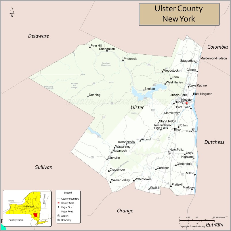
About Ulster County Map, New York: The map showing the county boundary, county seat, major cities, highways, water bodies and neighbouring counties.
Related NY Maps & Info
About Ulster County, New York
Ulster County is a county located in the U.S. state of New York. It's county seat is Kingston. As per 2020 census, the population of Ulster County is 182951 people and population density is 157.58 square miles. According to the United States Census Bureau, the county has a total area of 1,161 sq mi (3,007 km2). Ulster County was established on 1683.
Facts about Ulster County, New York
| Country | United States |
| State | New York |
| Region | Hudson Valley / Catskills |
| County Seat | Kingston |
| Founded | 1683 (one of New York’s original counties) |
| Named For | Province of Ulster in Ireland |
| Coordinates | 41.95° N, 74.00° W |
| Total Area | 1,161 sq mi |
| Land Area | 1,126 sq mi |
| Water Area | 35 sq mi |
| Water % | 3.0% |
| Population (2020) | 181,851 |
| Estimated Population (2024) | 182,977 |
| Population Density | 162/sq mi |
| Largest Municipality | Kingston (city) |
| Other Towns & Communities | Saugerties, New Paltz, Ellenville, Woodstock, Esopus, Lloyd |
| Main Industries | Tourism, Agriculture, Services, Education, Recreation |
| Major Highways | I‑87 (NYS Thruway), U.S. 209, NY‑28, NY‑32, NY‑55 |
| Time Zone | Eastern Time (UTC−05:00) |
| Known For | Historic Kingston (first NY capital), Hudson River scenery, Catskill Mountains, Mohonk Preserve, Minnewaska State Park |
| Website | https://www.ulstercountyny.gov/ |
Top Attractions in Ulster County, New York
- Mohonk Preserve – Cliffs, trails, and rock climbing.
- Minnewaska State Park Preserve – Lakes and mountain views.
- Mohonk Mountain House – Historic resort and scenery.
- Walkway Over the Hudson – Pedestrian bridge with views.
- Ashokan Reservoir – Scenic reservoir and trails.
- Woodstock Village – Arts, shops, and culture.
- Kingston Rondout Waterfront – Historic harbor district.
- Catskill Mountains – Hiking and outdoor recreation.
- Esopus Meadows Preserve – Hudson River nature area.
- Saugerties Lighthouse – Historic lighthouse hike.
- Opus 40 Sculpture Park – Outdoor stone art park.
- Tuthilltown Spirits Distillery – Craft spirits and tours.
Cities & Towns in Ulster County, New York
Kingston, New Paltz, Saugerties, Woodstock, Ellenville, Rosendale, Marlboro, Shawangunk, Highland, Hurley, Plattekill, Wawarsing, Esopus, Olive, Kingston Center, Accord, Pine Bush, Lake Katrine
- Albany County Map
- Allegany County Map
- Bronx County Map
- Broome County Map
- Cattaraugus County Map
- Cayuga County Map
- Chautauqua County Map
- Chemung County Map
- Chenango County Map
- Clinton County Map
- Columbia County Map
- Cortland County Map
- Delaware County Map
- Dutchess County Map
- Erie County Map
- Essex County Map
- Franklin County Map
- Fulton County Map
- Genesee County Map
- Greene County Map
- Hamilton County Map
- Herkimer County Map
- Jefferson County Map
- Kings County Map
- Lewis County Map
- Livingston County Map
- Madison County Map
- Monroe County Map
- Montgomery County Map
- Nassau County Map
- New York County Map
- Niagara County Map
- Oneida County Map
- Onondaga County Map
- Ontario County Map
- Orange County Map
- Orleans County Map
- Oswego County Map
- Otsego County Map
- Putnam County Map
- Queens County Map
- Rensselaer County Map
- Richmond County Map
- Rockland County Map
- St Lawrence County Map
- Saratoga County Map
- Schenectady County Map
- Schoharie County Map
- Schuyler County Map
- Seneca County Map
- Steuben County Map
- Suffolk County Map
- Sullivan County Map
- Tioga County Map
- Tompkins County Map
- Ulster County Map
- Warren County Map
- Washington County Map
- Wayne County Map
- Westchester County Map
- Wyoming County Map
- Yates County Map
- Alabama Counties
- Alaska boroughs
- Arizona Counties
- Arkansas Counties
- California County Map
- Colorado Counties
- Connecticut Counties
- Delaware Counties
- Florida County Map
- Georgia County Map
- Hawaii Counties
- Idaho Counties
- Illinois Counties
- Indiana Counties
- Iowa Counties
- Kansas Counties
- Kentucky Counties
- Louisiana Counties
- Maine Counties
- Maryland Counties
- Massachusetts Counties
- Michigan County Map
- Minnesota Counties
- Mississippi Counties
- Missouri Counties
- Montana Counties
- Nebraska Counties
- Nevada Counties
- New York Counties
- New Hampshire Counties
- New Jersey Counties
- New Mexico Counties
- North Carolina Counties
- North Dakota Counties
- Ohio County Map
- Oklahoma Counties
- Oregon Counties
- Pennsylvania Counties
- Rhode Island Counties
- South Carolina Counties
- South Dakota Counties
- Map of Tennessee
- Texas County Map
- Utah Counties
- Vermont Counties
- Virginia Counties
- Washington Counties
- West Virginia Counties
- Wisconsin Counties
- Wyoming Counties