Written and Fact-checked by Mukesh Kumar | Updated On: April 256 2026 | 15:50 ET
Map of Wayne County - Wayne County is a county located in the U.S. state of New York. Wayne County Map showing cities, highways, important places and water bodies. Get Where is Wayne County located in the map, major cities in Wayne county, population, areas, and places of interest.
Map of Wayne County, New York
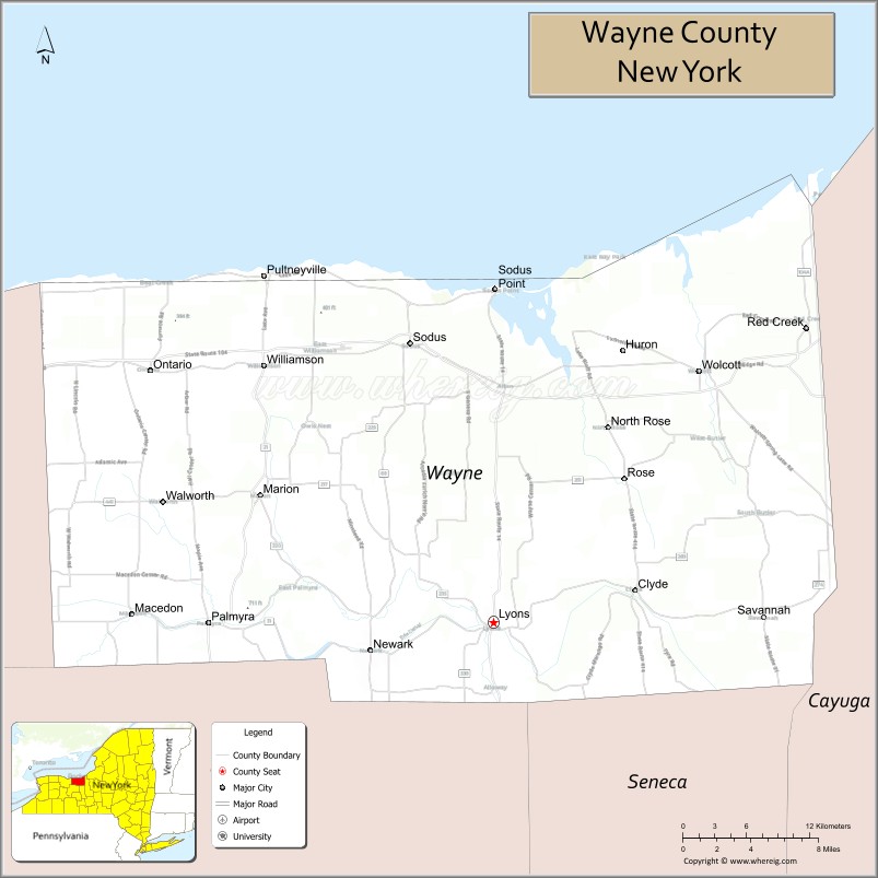
About Wayne County Map, New York: The map showing the county boundary, county seat, major cities, highways, water bodies and neighbouring counties.
Related NY Maps & Info
About Wayne County, New York
Wayne County is a county located in the U.S. state of New York. It's county seat is Lyons. As per 2020 census, the population of Wayne County is 90923 people and population density is 65.7 square miles. According to the United States Census Bureau, the county has a total area of 1,384 sq mi (3,585 km2). Wayne County was established on 1823.
Facts about Wayne County, New York
| Country | United States |
| State | New York |
| Region | Finger Lakes / Western New York |
| County Seat | Lyons |
| Founded | April 11, 1823 |
| Named For | General Anthony Wayne (Revolutionary War hero) |
| Coordinates | 43.10° N, 77.05° W |
| Total Area | 1,383 sq mi |
| Land Area | 604 sq mi |
| Water Area | 779 sq mi |
| Water % | 56% |
| Population (2020) | 91,283 |
| Estimated Population (2024) | 90,700 – 91,100 |
| Population Density | 151/sq mi (land area) |
| Largest Town | Arcadia (town) |
| Other Towns & Communities | Newark, Clyde, Wolcott, Sodus, Palmyra, Macedon, Ontario, Marion, Galen, Butler |
| Main Industries | Agriculture (especially fruit), Manufacturing, Services, Tourism |
| Major Highways | NY‑31, NY‑104, NY‑14, NY‑89, U.S. 20 |
| Time Zone | Eastern Time (UTC−05:00) |
| Known For | Lake Ontario shoreline, Erie Canal heritage, orchards & fruit production, scenic Finger Lakes countryside |
| Website | https://www.waynecountyny.gov/ |
Top Attractions in Wayne County, New York
- Erie Canal – Historic waterway and trails.
- Chimney Bluffs State Park – Dramatic lake bluffs.
- Sodus Bay – Boating and waterfront views.
- Apple Orchards & Farm Markets – Seasonal fruit and produce.
- Palmyra Historic District – Early American history sites.
- Alling Coverlet Museum – Textile history exhibits.
- Hugh White Homestead – Historic frontier home.
- Ganondagan State Historic Site (nearby) – Seneca history.
- Newark-Arcadia Historical Society Museum – Local history.
- Sodus Point Lighthouse – Lake Ontario lighthouse.
- Wayne County Fairgrounds – County fair and events.
- Wolcott Falls Park – Waterfalls and picnic areas.
Cities & Towns in Wayne County, New York
Lyons, Newark, Macedon, Sodus, Williamson, Palmyra, Huron, Clyde, Wolcott, Ontario, Rose, Galen, Williamson Center, Marion, Walworth, Macedon Center
- Albany County Map
- Allegany County Map
- Bronx County Map
- Broome County Map
- Cattaraugus County Map
- Cayuga County Map
- Chautauqua County Map
- Chemung County Map
- Chenango County Map
- Clinton County Map
- Columbia County Map
- Cortland County Map
- Delaware County Map
- Dutchess County Map
- Erie County Map
- Essex County Map
- Franklin County Map
- Fulton County Map
- Genesee County Map
- Greene County Map
- Hamilton County Map
- Herkimer County Map
- Jefferson County Map
- Kings County Map
- Lewis County Map
- Livingston County Map
- Madison County Map
- Monroe County Map
- Montgomery County Map
- Nassau County Map
- New York County Map
- Niagara County Map
- Oneida County Map
- Onondaga County Map
- Ontario County Map
- Orange County Map
- Orleans County Map
- Oswego County Map
- Otsego County Map
- Putnam County Map
- Queens County Map
- Rensselaer County Map
- Richmond County Map
- Rockland County Map
- St Lawrence County Map
- Saratoga County Map
- Schenectady County Map
- Schoharie County Map
- Schuyler County Map
- Seneca County Map
- Steuben County Map
- Suffolk County Map
- Sullivan County Map
- Tioga County Map
- Tompkins County Map
- Ulster County Map
- Warren County Map
- Washington County Map
- Wayne County Map
- Westchester County Map
- Wyoming County Map
- Yates County Map
- Alabama Counties
- Alaska boroughs
- Arizona Counties
- Arkansas Counties
- California County Map
- Colorado Counties
- Connecticut Counties
- Delaware Counties
- Florida County Map
- Georgia County Map
- Hawaii Counties
- Idaho Counties
- Illinois Counties
- Indiana Counties
- Iowa Counties
- Kansas Counties
- Kentucky Counties
- Louisiana Counties
- Maine Counties
- Maryland Counties
- Massachusetts Counties
- Michigan County Map
- Minnesota Counties
- Mississippi Counties
- Missouri Counties
- Montana Counties
- Nebraska Counties
- Nevada Counties
- New York Counties
- New Hampshire Counties
- New Jersey Counties
- New Mexico Counties
- North Carolina Counties
- North Dakota Counties
- Ohio County Map
- Oklahoma Counties
- Oregon Counties
- Pennsylvania Counties
- Rhode Island Counties
- South Carolina Counties
- South Dakota Counties
- Map of Tennessee
- Texas County Map
- Utah Counties
- Vermont Counties
- Virginia Counties
- Washington Counties
- West Virginia Counties
- Wisconsin Counties
- Wyoming Counties