Written and Fact-checked by Mukesh Kumar | Updated On: April 256 2026 | 15:50 ET
Map of Essex County - Essex County is a county located in the U.S. state of New York. Essex County Map showing cities, highways, important places and water bodies. Get Where is Essex County located in the map, major cities in Essex county, population, areas, and places of interest.
Map of Essex County, New York
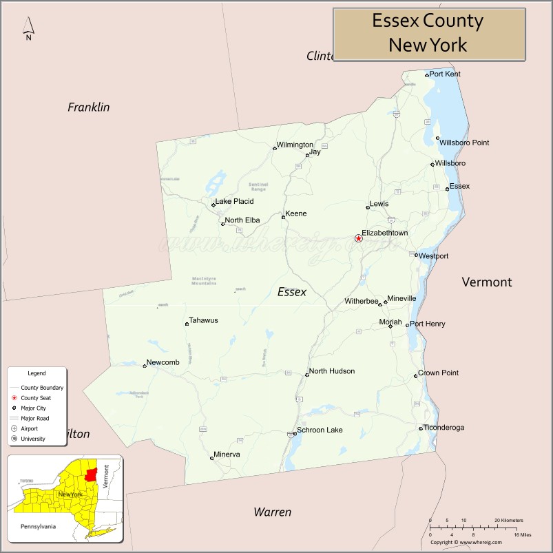
About Essex County Map, New York: The map showing the county boundary, county seat, major cities, highways, water bodies and neighbouring counties.
Related NY Maps & Info
About Essex County, New York
Essex County is a county located in the U.S. state of New York. It's county seat is Elizabethtown. As per 2020 census, the population of Essex County is 37268 people and population density is 19.45 square miles. According to the United States Census Bureau, the county has a total area of 1,916 sq mi (4,962 km2). Essex County was established on 1799.
Facts about Essex County, New York
| Country | United States |
| State | New York |
| Region | Northern New York / North Country (Adirondack Park) |
| County Seat | Elizabethtown |
| Founded | March 1, 1799 |
| Named For | Essex, England |
| Coordinates | 44.18° N, ‑73.65° W |
| Total Area | 1,916 sq mi |
| Land Area | 1,794 sq mi |
| Water Area | 122 sq mi |
| Water % | 6.4% |
| Population (2020) | 37,381 |
| Estimated Population (2024) | 37,000+ |
| Population Density | 20.8/sq mi |
| Largest Community | Ticonderoga (CDP) |
| Other Towns & Communities | Lake Placid, Keene, Westport, Schroon Lake, North Elba |
| Main Industries | Tourism, Outdoor recreation, Services, Forestry |
| Major Highways | I‑87 (Adirondack Northway), U.S. 9, NY‑22, NY‑73 |
| Time Zone | Eastern Time (UTC−05:00) |
| Known For | Adirondack Mountains, Lake Champlain, Mount Marcy, Lake Placid Olympic sites |
| Website | https://essexcountyny.gov/ |
Top Attractions in Essex County, New York
- Lake Placid – Olympic village and mountain resort.
- Whiteface Mountain – Skiing and scenic summit views.
- Adirondack High Peaks – Hiking and wilderness scenery.
- Olympic Center – Historic Winter Olympics venues.
- Ausable Chasm – Dramatic stone gorge.
- Lake Champlain – Boating and lakeside recreation.
- High Falls Gorge – Waterfalls and walkways.
- Adirondack Museum (nearby) – Regional history and culture.
- Hurricane Mountain Fire Tower – Panoramic hiking destination.
- Wilmington Wild Forest – Trails and outdoor activities.
- Elizabethtown Historic District – County seat landmarks.
- John Brown Farm State Historic Site – Abolitionist history site.
Cities & Towns in Essex County, New York
Elizabethtown, Ticonderoga, Lake Placid, Keene, Westport, Moriah, Crown Point, North Hudson, Jay, Essex, Willsboro, Lewis, Minerva, Schroon, Newcomb, Wilmington, Au Sable Forks, Au Sable, Black Brook
- Albany County Map
- Allegany County Map
- Bronx County Map
- Broome County Map
- Cattaraugus County Map
- Cayuga County Map
- Chautauqua County Map
- Chemung County Map
- Chenango County Map
- Clinton County Map
- Columbia County Map
- Cortland County Map
- Delaware County Map
- Dutchess County Map
- Erie County Map
- Essex County Map
- Franklin County Map
- Fulton County Map
- Genesee County Map
- Greene County Map
- Hamilton County Map
- Herkimer County Map
- Jefferson County Map
- Kings County Map
- Lewis County Map
- Livingston County Map
- Madison County Map
- Monroe County Map
- Montgomery County Map
- Nassau County Map
- New York County Map
- Niagara County Map
- Oneida County Map
- Onondaga County Map
- Ontario County Map
- Orange County Map
- Orleans County Map
- Oswego County Map
- Otsego County Map
- Putnam County Map
- Queens County Map
- Rensselaer County Map
- Richmond County Map
- Rockland County Map
- St Lawrence County Map
- Saratoga County Map
- Schenectady County Map
- Schoharie County Map
- Schuyler County Map
- Seneca County Map
- Steuben County Map
- Suffolk County Map
- Sullivan County Map
- Tioga County Map
- Tompkins County Map
- Ulster County Map
- Warren County Map
- Washington County Map
- Wayne County Map
- Westchester County Map
- Wyoming County Map
- Yates County Map
- Alabama Counties
- Alaska boroughs
- Arizona Counties
- Arkansas Counties
- California County Map
- Colorado Counties
- Connecticut Counties
- Delaware Counties
- Florida County Map
- Georgia County Map
- Hawaii Counties
- Idaho Counties
- Illinois Counties
- Indiana Counties
- Iowa Counties
- Kansas Counties
- Kentucky Counties
- Louisiana Counties
- Maine Counties
- Maryland Counties
- Massachusetts Counties
- Michigan County Map
- Minnesota Counties
- Mississippi Counties
- Missouri Counties
- Montana Counties
- Nebraska Counties
- Nevada Counties
- New York Counties
- New Hampshire Counties
- New Jersey Counties
- New Mexico Counties
- North Carolina Counties
- North Dakota Counties
- Ohio County Map
- Oklahoma Counties
- Oregon Counties
- Pennsylvania Counties
- Rhode Island Counties
- South Carolina Counties
- South Dakota Counties
- Map of Tennessee
- Texas County Map
- Utah Counties
- Vermont Counties
- Virginia Counties
- Washington Counties
- West Virginia Counties
- Wisconsin Counties
- Wyoming Counties