Written and Fact-checked by Mukesh Kumar | Updated On: April 256 2026 | 15:50 ET
Map of Fulton County - Fulton County is a county located in the U.S. state of New York. Fulton County Map showing cities, highways, important places and water bodies. Get Where is Fulton County located in the map, major cities in Fulton county, population, areas, and places of interest.
Map of Fulton County, New York
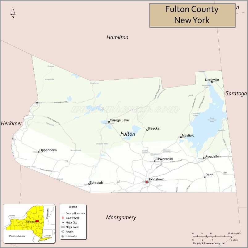
About Fulton County Map, New York: The map showing the county boundary, county seat, major cities, highways, water bodies and neighbouring counties.
Related NY Maps & Info
About Fulton County, New York
Fulton County is a county located in the U.S. state of New York. It's county seat is Johnstown. As per 2020 census, the population of Fulton County is 53116 people and population density is 99.65 square miles. According to the United States Census Bureau, the county has a total area of 533 sq mi (1,380 km2). Fulton County was established on 1838.
Facts about Fulton County, New York
| Country | United States |
| State | New York |
| Region | Mohawk Valley / Southern Adirondacks |
| County Seat | Johnstown |
| Founded | April 18, 1838 |
| Named For | Robert Fulton, inventor and engineer |
| Coordinates | 43.04° N, 74.37° W |
| Total Area | 533 sq mi |
| Land Area | 495 sq mi |
| Water Area | 37 sq mi |
| Water % | 7.0% |
| Population (2020) | 53,324 |
| Estimated Population (2024) | 53,000+ |
| Population Density | 108/sq mi |
| Largest City | Gloversville |
| Other Communities | Johnstown, Broadalbin, Mayfield, Northville, Caroga Lake, Ephratah, Oppenheim, Perth, Stratford |
| Main Industries | Manufacturing (historically leather/gloves), Services, Agriculture, Tourism |
| Major Highways | NY‑29, NY‑30A, NY‑10, NY‑29A |
| Time Zone | Eastern Time (UTC−05:00) |
| Known For | Adirondack landscapes, Great Sacandaga Lake, historic glove‑making heritage |
| Website | https://fultoncountyny.gov/ |
Top Attractions in Fulton County, New York
- Great Sacandaga Lake – Boating, fishing, and lake views.
- Adirondack Experience (nearby) – Adirondack history museum.
- Johnstown Historical Society Museum – Local history exhibits.
- Johnson Hall State Historic Site – Sir William Johnson’s estate.
- Fulton County Museum – County history and culture.
- Gloversville Downtown Historic District – Shops and architecture.
- Mayfield Lake – Fishing and water recreation.
- Adirondack Foothills Trails – Hiking and biking paths.
- Hales Mills Covered Bridge – Historic covered bridge.
- Peck Hill State Forest – Forest trails and scenery.
- Royal Mountain Ski Area – Skiing and winter sports.
- Mohawk River (nearby) – Scenic river views.
Cities & Towns in Fulton County, New York
Gloversville, Johnstown, Broadalbin, Mayfield, Caroga, Northville, Stratford, Oppenheim, Ephratah, Bleecker, Perth, Sacandaga, Broadalbin, Oppenheim Center
- Albany County Map
- Allegany County Map
- Bronx County Map
- Broome County Map
- Cattaraugus County Map
- Cayuga County Map
- Chautauqua County Map
- Chemung County Map
- Chenango County Map
- Clinton County Map
- Columbia County Map
- Cortland County Map
- Delaware County Map
- Dutchess County Map
- Erie County Map
- Essex County Map
- Franklin County Map
- Fulton County Map
- Genesee County Map
- Greene County Map
- Hamilton County Map
- Herkimer County Map
- Jefferson County Map
- Kings County Map
- Lewis County Map
- Livingston County Map
- Madison County Map
- Monroe County Map
- Montgomery County Map
- Nassau County Map
- New York County Map
- Niagara County Map
- Oneida County Map
- Onondaga County Map
- Ontario County Map
- Orange County Map
- Orleans County Map
- Oswego County Map
- Otsego County Map
- Putnam County Map
- Queens County Map
- Rensselaer County Map
- Richmond County Map
- Rockland County Map
- St Lawrence County Map
- Saratoga County Map
- Schenectady County Map
- Schoharie County Map
- Schuyler County Map
- Seneca County Map
- Steuben County Map
- Suffolk County Map
- Sullivan County Map
- Tioga County Map
- Tompkins County Map
- Ulster County Map
- Warren County Map
- Washington County Map
- Wayne County Map
- Westchester County Map
- Wyoming County Map
- Yates County Map
- Alabama Counties
- Alaska boroughs
- Arizona Counties
- Arkansas Counties
- California County Map
- Colorado Counties
- Connecticut Counties
- Delaware Counties
- Florida County Map
- Georgia County Map
- Hawaii Counties
- Idaho Counties
- Illinois Counties
- Indiana Counties
- Iowa Counties
- Kansas Counties
- Kentucky Counties
- Louisiana Counties
- Maine Counties
- Maryland Counties
- Massachusetts Counties
- Michigan County Map
- Minnesota Counties
- Mississippi Counties
- Missouri Counties
- Montana Counties
- Nebraska Counties
- Nevada Counties
- New York Counties
- New Hampshire Counties
- New Jersey Counties
- New Mexico Counties
- North Carolina Counties
- North Dakota Counties
- Ohio County Map
- Oklahoma Counties
- Oregon Counties
- Pennsylvania Counties
- Rhode Island Counties
- South Carolina Counties
- South Dakota Counties
- Map of Tennessee
- Texas County Map
- Utah Counties
- Vermont Counties
- Virginia Counties
- Washington Counties
- West Virginia Counties
- Wisconsin Counties
- Wyoming Counties