Written and Fact-checked by Mukesh Kumar | Updated On: April 256 2026 | 15:50 ET
Map of Tompkins County - Tompkins County is a county located in the U.S. state of New York. Tompkins County Map showing cities, highways, important places and water bodies. Get Where is Tompkins County located in the map, major cities in Tompkins county, population, areas, and places of interest.
Map of Tompkins County, New York
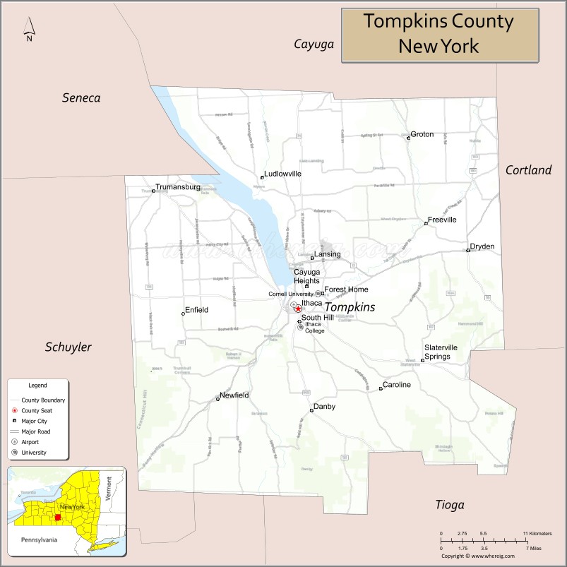
About Tompkins County Map, New York: The map showing the county boundary, county seat, major cities, highways, water bodies and neighbouring counties.
Related NY Maps & Info
About Tompkins County, New York
Tompkins County is a county located in the U.S. state of New York. It's county seat is Ithaca. As per 2020 census, the population of Tompkins County is 105162 people and population density is 220.93 square miles. According to the United States Census Bureau, the county has a total area of 476 sq mi (1,233 km2). Tompkins County was established on 1817.
Facts about Tompkins County, New York
| Country | United States |
| State | New York |
| Region | Finger Lakes / Southern Tier |
| County Seat | Ithaca |
| Founded | April 17, 1817 |
| Named For | Daniel D. Tompkins (Governor of NY, U.S. Vice President) |
| Coordinates | 42.50° N, 76.45° W |
| Total Area | 492 sq mi |
| Land Area | 475 sq mi |
| Water Area | 17 sq mi |
| Water % | 3.4% |
| Population (2020) | 105,740 |
| Estimated Population (2024/25) | 105,699+ |
| Population Density | 223/sq mi |
| Largest City | Ithaca |
| Other Towns & Communities | Dryden, Lansing, Groton, Enfield, Ulysses, Newfield, Caroline |
| Main Industries | Education, Research, Services, Agriculture, Tourism |
| Major Highways | NY‑13, NY‑34, NY‑79, NY‑89, NY‑96 |
| Time Zone | Eastern Time (UTC−05:00) |
| Known For | Cornell University, Ithaca College, Finger Lakes scenery & waterfalls, gorges & parks |
| Website | https://tompkinscountyny.gov/ |
Top Attractions in Tompkins County, New York
- Buttermilk Falls State Park – Waterfalls and hiking trails.
- Taughannock Falls State Park – Tall waterfall and gorge.
- Ithaca Commons – Pedestrian shopping and dining area.
- Cornell University Campus – Historic campus and scenery.
- Cayuga Lake – Boating and lakeside views.
- Robert H. Treman State Park – Gorge trails and waterfalls.
- Sciencenter – Hands-on science museum.
- Herbert F. Johnson Museum of Art – Art museum with lake views.
- Ithaca Falls – Dramatic downtown waterfall.
- Cascadilla Gorge Trail – Stone stairway gorge walk.
- Cayuga Nature Center – Nature trails and exhibits.
- Finger Lakes Wine Trail – Wineries and tastings.
Cities & Towns in Tompkins County, New York
Ithaca, Cortlandville (partly), Dryden, Trumansburg, Groton, Newfield, Lansing, Caroline, Enfield, Ulysses, Freeville, Brooktondale, Brookton, Slaterville Springs, Cayuga Heights, Ithaca College
- Albany County Map
- Allegany County Map
- Bronx County Map
- Broome County Map
- Cattaraugus County Map
- Cayuga County Map
- Chautauqua County Map
- Chemung County Map
- Chenango County Map
- Clinton County Map
- Columbia County Map
- Cortland County Map
- Delaware County Map
- Dutchess County Map
- Erie County Map
- Essex County Map
- Franklin County Map
- Fulton County Map
- Genesee County Map
- Greene County Map
- Hamilton County Map
- Herkimer County Map
- Jefferson County Map
- Kings County Map
- Lewis County Map
- Livingston County Map
- Madison County Map
- Monroe County Map
- Montgomery County Map
- Nassau County Map
- New York County Map
- Niagara County Map
- Oneida County Map
- Onondaga County Map
- Ontario County Map
- Orange County Map
- Orleans County Map
- Oswego County Map
- Otsego County Map
- Putnam County Map
- Queens County Map
- Rensselaer County Map
- Richmond County Map
- Rockland County Map
- St Lawrence County Map
- Saratoga County Map
- Schenectady County Map
- Schoharie County Map
- Schuyler County Map
- Seneca County Map
- Steuben County Map
- Suffolk County Map
- Sullivan County Map
- Tioga County Map
- Tompkins County Map
- Ulster County Map
- Warren County Map
- Washington County Map
- Wayne County Map
- Westchester County Map
- Wyoming County Map
- Yates County Map
- Alabama Counties
- Alaska boroughs
- Arizona Counties
- Arkansas Counties
- California County Map
- Colorado Counties
- Connecticut Counties
- Delaware Counties
- Florida County Map
- Georgia County Map
- Hawaii Counties
- Idaho Counties
- Illinois Counties
- Indiana Counties
- Iowa Counties
- Kansas Counties
- Kentucky Counties
- Louisiana Counties
- Maine Counties
- Maryland Counties
- Massachusetts Counties
- Michigan County Map
- Minnesota Counties
- Mississippi Counties
- Missouri Counties
- Montana Counties
- Nebraska Counties
- Nevada Counties
- New York Counties
- New Hampshire Counties
- New Jersey Counties
- New Mexico Counties
- North Carolina Counties
- North Dakota Counties
- Ohio County Map
- Oklahoma Counties
- Oregon Counties
- Pennsylvania Counties
- Rhode Island Counties
- South Carolina Counties
- South Dakota Counties
- Map of Tennessee
- Texas County Map
- Utah Counties
- Vermont Counties
- Virginia Counties
- Washington Counties
- West Virginia Counties
- Wisconsin Counties
- Wyoming Counties