Written and Fact-checked by Whereig Web Team | Updated On: September 17, 2025, 14:10 ET
Map of Yates County - Yates County is a county located in the U.S. state of New York. Yates County Map showing cities, highways, important places and water bodies. Get Where is Yates County located in the map, major cities in Yates county, population, areas, and places of interest.
Map of Yates County, New York
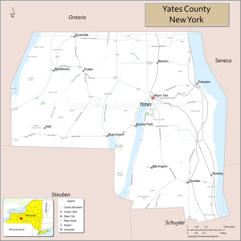
About Yates County Map, New York: The map showing the county boundary, county seat, major cities, highways, water bodies and neighbouring counties.
More New NY Maps & Info
About Yates County, New York
Yates County is a county located in the U.S. state of New York. It's county seat is Penn Yan. As per 2020 census, the population of Yates County is 24613 people and population density is 65.46 square miles. According to the United States Census Bureau, the county has a total area of 376 sq mi (974 km2). Yates County was established on 1823.
Facts about Yates County, New York
| Country | United States |
| State | New York |
| Region | Finger Lakes / Central Western New York |
| County Seat | Penn Yan |
| Founded | February 5, 1823 |
| Named For | Joseph C. Yates (Governor of New York) |
| Coordinates | ~42.69° N, 77.07° W |
| Total Area | ~376 sq mi |
| Land Area | ~338 sq mi |
| Water Area | ~38 sq mi |
| Water % | ~10% |
| Population (2020) | ~24,766 |
| Estimated Population (2024) | ~24,387 |
| Population Density | ~72/sq mi |
| Largest Municipality | Milo (town) |
| Other Towns & Communities | Penn Yan (village), Dundee, Jerusalem, Barrington, Benton |
| Main Industries | Agriculture (vineyards & fruit farms), Tourism, Services |
| Major Highways | NY‑14, NY‑54, NY‑230 |
| Time Zone | Eastern Time (UTC−05:00) |
| Known For | Finger Lakes scenery, Keuka Lake, wine trails & vineyards, rural landscapes |
| Website | https://www.yatescountyny.gov/ |
Top Attractions in Yates County, New York
- Keuka Lake – Boating, fishing, and lake views.
- Keuka Lake Wine Trail – Wineries and tastings.
- Glenn H. Curtiss Museum (nearby) – Aviation history exhibits.
- Penn Yan Historic District – Shops and historic buildings.
- Keuka Outlet Trail – Scenic walking and biking path.
- Yates County History Center – Local history museum.
- Oliver House Museum – Victorian-era historic home.
- Lake Street Plaza – Waterfront park and views.
- Windmill Farm & Craft Market – Local goods and food.
- Bluff Point Vineyards – Winery with lake overlooks.
- Seneca Mills Falls – Small scenic waterfall.
- Dresden Village – Quiet lakeside community.
Cities & Towns in Yates County, New York
Dresden, Penn Yan, Benton, Milo, Jerusalem, Italy, Torrey, Dundee, Himrod, Rushville, Branchport, Middlesex, Dundee Center
- Albany County Map
- Allegany County Map
- Bronx County Map
- Broome County Map
- Cattaraugus County Map
- Cayuga County Map
- Chautauqua County Map
- Chemung County Map
- Chenango County Map
- Clinton County Map
- Columbia County Map
- Cortland County Map
- Delaware County Map
- Dutchess County Map
- Erie County Map
- Essex County Map
- Franklin County Map
- Fulton County Map
- Genesee County Map
- Greene County Map
- Hamilton County Map
- Herkimer County Map
- Jefferson County Map
- Kings County Map
- Lewis County Map
- Livingston County Map
- Madison County Map
- Monroe County Map
- Montgomery County Map
- Nassau County Map
- New York County Map
- Niagara County Map
- Oneida County Map
- Onondaga County Map
- Ontario County Map
- Orange County Map
- Orleans County Map
- Oswego County Map
- Otsego County Map
- Putnam County Map
- Queens County Map
- Rensselaer County Map
- Richmond County Map
- Rockland County Map
- St Lawrence County Map
- Saratoga County Map
- Schenectady County Map
- Schoharie County Map
- Schuyler County Map
- Seneca County Map
- Steuben County Map
- Suffolk County Map
- Sullivan County Map
- Tioga County Map
- Tompkins County Map
- Ulster County Map
- Warren County Map
- Washington County Map
- Wayne County Map
- Westchester County Map
- Wyoming County Map
- Yates County Map
- Alabama Counties
- Alaska boroughs
- Arizona Counties
- Arkansas Counties
- California County Map
- Colorado Counties
- Connecticut Counties
- Delaware Counties
- Florida County Map
- Georgia County Map
- Hawaii Counties
- Idaho Counties
- Illinois Counties
- Indiana Counties
- Iowa Counties
- Kansas Counties
- Kentucky Counties
- Louisiana Counties
- Maine Counties
- Maryland Counties
- Massachusetts Counties
- Michigan County Map
- Minnesota Counties
- Mississippi Counties
- Missouri Counties
- Montana Counties
- Nebraska Counties
- New Hampshire Counties
- New Jersey Counties
- New Mexico Counties
- North Carolina Counties
- North Dakota Counties
- Oklahoma Counties
- Oregon Counties
- Pennsylvania Counties
- Rhode Island Counties
- South Carolina Counties
- South Dakota Counties
- Map of Tennessee
- Texas County Map
- Utah Counties
- Vermont Counties
- Virginia Counties
- Washington Counties
- West Virginia Counties
- Wisconsin Counties
- Wyoming Counties
- Nevada Counties
- New York Counties
- Ohio County Map