Written and Fact-checked by Mukesh Kumar | Updated On: April 256 2026 | 15:50 ET
Map of New York County - New York County is a county located in the U.S. state of New York. New York County Map showing cities, highways, important places and water bodies. Get Where is New York County located in the map, major cities in New York county, population, areas, and places of interest.
Map of New York County, New York
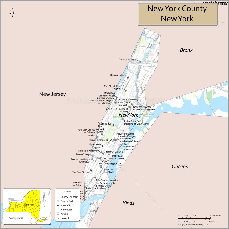
About New York County Map, New York: The map showing the county boundary, county seat, major cities, highways, water bodies and neighbouring counties.
Related NY Maps & Info
About New York County, New York
New York County is a county located in the U.S. state of New York. It's county seat is none (sui generis). As per 2020 census, the population of New York County is 1576876 people and population density is 46694.58 square miles. According to the United States Census Bureau, the county has a total area of 33.77 sq mi (87 km2). New York County was established on 1683.e miles. According to the United States Census Bureau, the county has a total area of 1,312 sq mi (3,398 km2). Oswego County was established on 1816.
Facts about New York County, New York
| Country | United States |
| State | New York |
| Region | New York City / Southern New York |
| County Seat | Manhattan (coextensive with borough) |
| Founded | 1683 |
| Named For | City of New York (original colonial county name) |
| Coordinates | 40.78° N, 73.97° W |
| Total Area | 22.66 sq mi (land) |
| Land Area | 22.66 sq mi |
| Water Area | Included in NYC total (significant surrounding waterways) |
| Water % | Varies (surrounded by rivers & harbor) |
| Population (2020) | 1,694,250 |
| Estimated Population (2024) | 1,688,099 |
| Population Density | 72,900/sq mi |
| Largest Municipality | Manhattan |
| Other Areas | Neighborhoods such as Harlem, Upper East Side, Midtown, Lower Manhattan, Chinatown |
| Main Industries | Finance, Media, Technology, Arts & Culture, Government |
| Major Highways | FDR Drive, West Side Hwy, Broadway |
| Time Zone | Eastern Time (UTC−05:00) |
| Known For | Wall Street & Financial District, Broadway, Central Park, Times Square, UN Headquarters |
| Website | https://www.manhattanbp.nyc.gov/ |
Top Attractions in New York County, New York
- Central Park – Iconic urban park.
- Times Square – Famous entertainment district.
- Statue of Liberty – National symbol and monument.
- Empire State Building – Landmark skyscraper and views.
- Metropolitan Museum of Art – World-class art museum.
- Broadway Theater District – Live theater performances.
- Wall Street – Financial district landmark.
- One World Trade Center – Tallest building in NYC.
- 9/11 Memorial & Museum – Historic memorial site.
- Fifth Avenue – Shopping and landmarks.
- High Line – Elevated urban park.
- Rockefeller Center – Observation deck and attractions.
Cities & Towns in New York County, New York
Manhattan, Harlem, Upper East Side, Upper West Side, Midtown, Chelsea, Greenwich Village, East Village, West Village, Tribeca, SoHo, Financial District, Lower East Side, Washington Heights, Inwood, Morningside Heights, Hamilton Heights
- Albany County Map
- Allegany County Map
- Bronx County Map
- Broome County Map
- Cattaraugus County Map
- Cayuga County Map
- Chautauqua County Map
- Chemung County Map
- Chenango County Map
- Clinton County Map
- Columbia County Map
- Cortland County Map
- Delaware County Map
- Dutchess County Map
- Erie County Map
- Essex County Map
- Franklin County Map
- Fulton County Map
- Genesee County Map
- Greene County Map
- Hamilton County Map
- Herkimer County Map
- Jefferson County Map
- Kings County Map
- Lewis County Map
- Livingston County Map
- Madison County Map
- Monroe County Map
- Montgomery County Map
- Nassau County Map
- New York County Map
- Niagara County Map
- Oneida County Map
- Onondaga County Map
- Ontario County Map
- Orange County Map
- Orleans County Map
- Oswego County Map
- Otsego County Map
- Putnam County Map
- Queens County Map
- Rensselaer County Map
- Richmond County Map
- Rockland County Map
- St Lawrence County Map
- Saratoga County Map
- Schenectady County Map
- Schoharie County Map
- Schuyler County Map
- Seneca County Map
- Steuben County Map
- Suffolk County Map
- Sullivan County Map
- Tioga County Map
- Tompkins County Map
- Ulster County Map
- Warren County Map
- Washington County Map
- Wayne County Map
- Westchester County Map
- Wyoming County Map
- Yates County Map
- Alabama Counties
- Alaska boroughs
- Arizona Counties
- Arkansas Counties
- California County Map
- Colorado Counties
- Connecticut Counties
- Delaware Counties
- Florida County Map
- Georgia County Map
- Hawaii Counties
- Idaho Counties
- Illinois Counties
- Indiana Counties
- Iowa Counties
- Kansas Counties
- Kentucky Counties
- Louisiana Counties
- Maine Counties
- Maryland Counties
- Massachusetts Counties
- Michigan County Map
- Minnesota Counties
- Mississippi Counties
- Missouri Counties
- Montana Counties
- Nebraska Counties
- Nevada Counties
- New York Counties
- New Hampshire Counties
- New Jersey Counties
- New Mexico Counties
- North Carolina Counties
- North Dakota Counties
- Ohio County Map
- Oklahoma Counties
- Oregon Counties
- Pennsylvania Counties
- Rhode Island Counties
- South Carolina Counties
- South Dakota Counties
- Map of Tennessee
- Texas County Map
- Utah Counties
- Vermont Counties
- Virginia Counties
- Washington Counties
- West Virginia Counties
- Wisconsin Counties
- Wyoming Counties