Written and Fact-checked by Mukesh Kumar | Updated On: April 256 2026 | 15:50 ET
Map of Washington County - Washington County is a county located in the U.S. state of New York. Washington County Map showing cities, highways, important places and water bodies. Get Where is Washington County located in the map, major cities in Washington county, population, areas, and places of interest.
Map of Washington County, New York
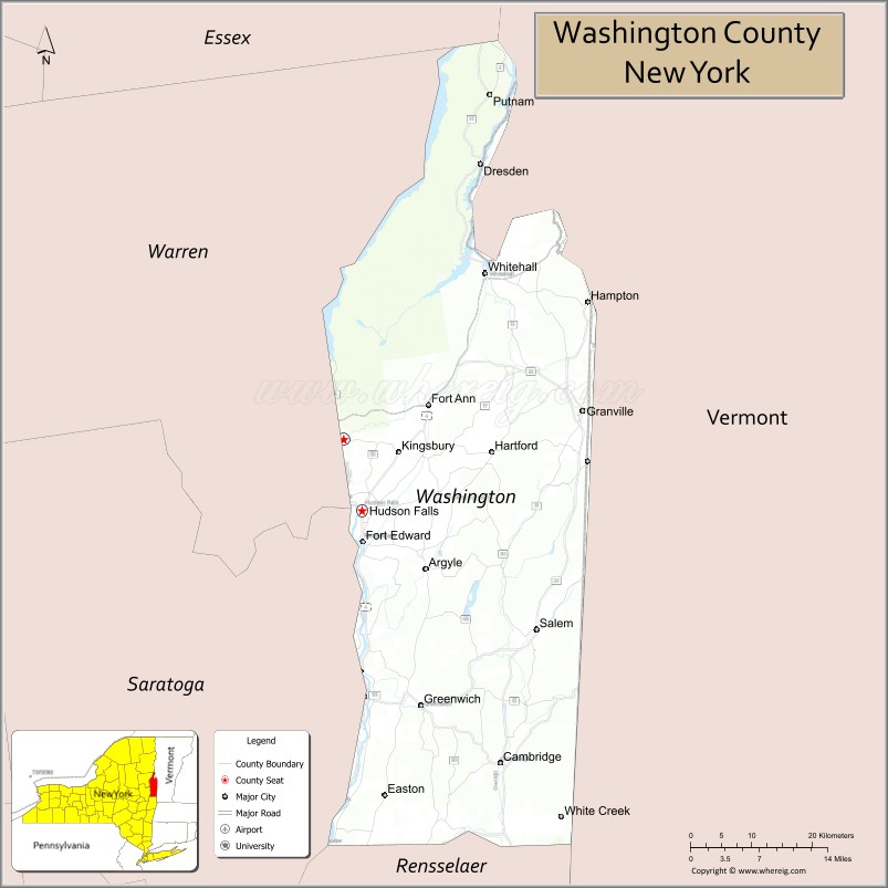
About Washington County Map, New York: The map showing the county boundary, county seat, major cities, highways, water bodies and neighbouring counties.
Related NY Maps & Info
About Washington County, New York
Washington County is a county located in the U.S. state of New York. It's county seat is Fort Edward. As per 2020 census, the population of Washington County is 60956 people and population density is 72.05 square miles. According to the United States Census Bureau, the county has a total area of 846 sq mi (2,191 km2). Washington County was established on 1772.
Facts about Washington County, New York
| Country | United States |
| State | New York |
| Region | Capital District / North Country (Champlain Valley & Adirondack foothills) |
| County Seat | Fort Edward |
| Founded | March 12, 1772 (as Charlotte County); renamed April 2, 1784 |
| Named For | George Washington (Revolutionary War general & first U.S. President) |
| Coordinates | 43.31° N, 73.44° W |
| Total Area | 846 sq mi |
| Land Area | 831 sq mi |
| Water Area | 15 sq mi |
| Water % | 1.7% |
| Population (2020) | 61,302 |
| Estimated Population (2024) | 60,000‑61,000+ |
| Population Density | 74/sq mi |
| Largest Town | Kingsbury (town) |
| Other Towns & Communities | Greenwich, Hudson Falls, Argyle, Cambridge, Whitehall, Fort Ann, Salem |
| Main Industries | Agriculture (dairy, maple & apples), Manufacturing (paper & medical products), Services |
| Major Highways | I‑87 (Adirondack Northway), U.S. 4, NY‑22, NY‑29 |
| Time Zone | Eastern Time (UTC−05:00) |
| Known For | Scenic rural landscapes, Batten Kill river fly fishing, Adirondack foothills, historic covered bridges |
| Website | https://www.washingtoncountyny.gov/ |
Top Attractions in Washington County, New York
- Saratoga National Historical Park – Revolutionary War battlefield.
- Hudson Falls Historic District – Architecture and village charm.
- Fort Edward Historic District – Colonial and military history.
- Washington County Fairgrounds – Annual fair and events.
- Lake George (nearby) – Boating and scenic views.
- Hudson River – Fishing and river scenery.
- Argyle Village Historic Area – Historic buildings and shops.
- Granville Slate Museum – Local slate industry history.
- Skene Manor – Victorian mansion and views.
- Slate Valley Museum – Regional industrial heritage.
- Champlain Canalway Trail – Walking and biking path.
- Cossayuna Lake – Quiet lake recreation.
Cities & Towns in Washington County, New York
Fort Edward, Hudson Falls, Granville, Greenwich, Salem, Argyle, Whitehall, Cambridge, Granville Center, Kingsbury, Dresden, Putnam, Hampton, White Creek, Fort Ann, Dresden Center
- Albany County Map
- Allegany County Map
- Bronx County Map
- Broome County Map
- Cattaraugus County Map
- Cayuga County Map
- Chautauqua County Map
- Chemung County Map
- Chenango County Map
- Clinton County Map
- Columbia County Map
- Cortland County Map
- Delaware County Map
- Dutchess County Map
- Erie County Map
- Essex County Map
- Franklin County Map
- Fulton County Map
- Genesee County Map
- Greene County Map
- Hamilton County Map
- Herkimer County Map
- Jefferson County Map
- Kings County Map
- Lewis County Map
- Livingston County Map
- Madison County Map
- Monroe County Map
- Montgomery County Map
- Nassau County Map
- New York County Map
- Niagara County Map
- Oneida County Map
- Onondaga County Map
- Ontario County Map
- Orange County Map
- Orleans County Map
- Oswego County Map
- Otsego County Map
- Putnam County Map
- Queens County Map
- Rensselaer County Map
- Richmond County Map
- Rockland County Map
- St Lawrence County Map
- Saratoga County Map
- Schenectady County Map
- Schoharie County Map
- Schuyler County Map
- Seneca County Map
- Steuben County Map
- Suffolk County Map
- Sullivan County Map
- Tioga County Map
- Tompkins County Map
- Ulster County Map
- Warren County Map
- Washington County Map
- Wayne County Map
- Westchester County Map
- Wyoming County Map
- Yates County Map
- Alabama Counties
- Alaska boroughs
- Arizona Counties
- Arkansas Counties
- California County Map
- Colorado Counties
- Connecticut Counties
- Delaware Counties
- Florida County Map
- Georgia County Map
- Hawaii Counties
- Idaho Counties
- Illinois Counties
- Indiana Counties
- Iowa Counties
- Kansas Counties
- Kentucky Counties
- Louisiana Counties
- Maine Counties
- Maryland Counties
- Massachusetts Counties
- Michigan County Map
- Minnesota Counties
- Mississippi Counties
- Missouri Counties
- Montana Counties
- Nebraska Counties
- Nevada Counties
- New York Counties
- New Hampshire Counties
- New Jersey Counties
- New Mexico Counties
- North Carolina Counties
- North Dakota Counties
- Ohio County Map
- Oklahoma Counties
- Oregon Counties
- Pennsylvania Counties
- Rhode Island Counties
- South Carolina Counties
- South Dakota Counties
- Map of Tennessee
- Texas County Map
- Utah Counties
- Vermont Counties
- Virginia Counties
- Washington Counties
- West Virginia Counties
- Wisconsin Counties
- Wyoming Counties