Written and Fact-checked by Mukesh Kumar | Updated On: April 256 2026 | 15:50 ET
Map of St. Lawrence County - St. Lawrence County is a county located in the U.S. state of New York. St. Lawrence County Map showing cities, highways, important places and water bodies. Get Where is St. Lawrence County located in the map, major cities in St. Lawrence county, population, areas, and places of interest.
Map of St Lawrence County, New York
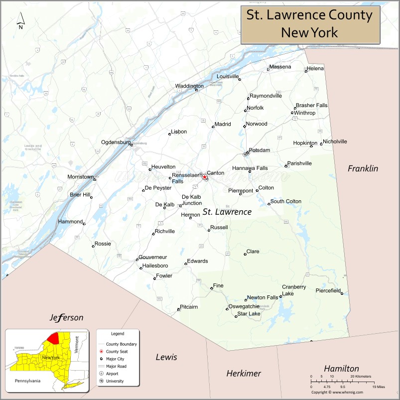
About St. Lawrence County Map, New York: The map showing the county boundary, county seat, major cities, highways, water bodies and neighbouring counties.
Related NY Maps & Info
About St Lawrence County, New York
St. Lawrence County is a county located in the U.S. state of New York. It's county seat is Canton. As per 2020 census, the population of St. Lawrence County is 108051 people and population density is 38.3 square miles. According to the United States Census Bureau, the county has a total area of 2,821 sq mi (7,306 km2). St. Lawrence County was established on 1802.
Facts about St. Lawrence County, New York
| Country | United States |
| State | New York |
| Region | North Country / Northern New York |
| County Seat | Canton |
| Founded | 1802 |
| Named For | Saint Lawrence River |
| Coordinates | 44.47° N, 75.23° W |
| Total Area | 2,821 sq mi |
| Land Area | 2,680 sq mi |
| Water Area | 141 sq mi |
| Water % | 5.0% |
| Population (2020) | 108,505 |
| Estimated Population (2024) | 106,198 |
| Population Density | 40/sq mi |
| Largest Municipality | Potsdam (town/CDP) |
| Other Towns & Communities | Ogdensburg, Massena, Gouverneur, Canton (village), Norwood, Edwards |
| Main Industries | Agriculture, Manufacturing, Education, Tourism, Services |
| Major Highways | U.S. 11, NY‑37, NY‑3, NY‑68 |
| Time Zone | Eastern Time (UTC−05:00) |
| Known For | St. Lawrence River & Seaway, Adirondack Park, Clarkson University & SUNY Canton, rural landscapes |
| Website | https://www.stlawco.gov/ |
Top Attractions in St. Lawrence County, New York
- St. Lawrence River – Boating and waterfront scenery.
- Thousand Islands Region – Island views and boat tours.
- Frederic Remington Art Museum – American Western art.
- Upper Canada Village (nearby) – Living history village.
- Robert Moses State Park – Riverfront park and trails.
- Higley Flow State Park – Camping and paddling.
- Massena International Kampground – Riverside camping.
- Nicandri Nature Center – Environmental education and trails.
- SUNY Potsdam Campus – Historic college grounds.
- Clarkson University – Campus and science centers.
- Remington Trail – Cultural and historic driving route.
- Grasse River – Fishing and paddling river.
Cities & Towns in St. Lawrence County, New York
Canton, Potsdam, Ogdensburg, Massena, Gouverneur, Norwood, Madrid, Brasher Falls, Malone, Colton, Lisbon, Hermon, Hopkinton, Parishville, Star Lake, Waddington, Morristown, Winthrop, Richville, Edwards
- Albany County Map
- Allegany County Map
- Bronx County Map
- Broome County Map
- Cattaraugus County Map
- Cayuga County Map
- Chautauqua County Map
- Chemung County Map
- Chenango County Map
- Clinton County Map
- Columbia County Map
- Cortland County Map
- Delaware County Map
- Dutchess County Map
- Erie County Map
- Essex County Map
- Franklin County Map
- Fulton County Map
- Genesee County Map
- Greene County Map
- Hamilton County Map
- Herkimer County Map
- Jefferson County Map
- Kings County Map
- Lewis County Map
- Livingston County Map
- Madison County Map
- Monroe County Map
- Montgomery County Map
- Nassau County Map
- New York County Map
- Niagara County Map
- Oneida County Map
- Onondaga County Map
- Ontario County Map
- Orange County Map
- Orleans County Map
- Oswego County Map
- Otsego County Map
- Putnam County Map
- Queens County Map
- Rensselaer County Map
- Richmond County Map
- Rockland County Map
- St Lawrence County Map
- Saratoga County Map
- Schenectady County Map
- Schoharie County Map
- Schuyler County Map
- Seneca County Map
- Steuben County Map
- Suffolk County Map
- Sullivan County Map
- Tioga County Map
- Tompkins County Map
- Ulster County Map
- Warren County Map
- Washington County Map
- Wayne County Map
- Westchester County Map
- Wyoming County Map
- Yates County Map
- Alabama Counties
- Alaska boroughs
- Arizona Counties
- Arkansas Counties
- California County Map
- Colorado Counties
- Connecticut Counties
- Delaware Counties
- Florida County Map
- Georgia County Map
- Hawaii Counties
- Idaho Counties
- Illinois Counties
- Indiana Counties
- Iowa Counties
- Kansas Counties
- Kentucky Counties
- Louisiana Counties
- Maine Counties
- Maryland Counties
- Massachusetts Counties
- Michigan County Map
- Minnesota Counties
- Mississippi Counties
- Missouri Counties
- Montana Counties
- Nebraska Counties
- Nevada Counties
- New York Counties
- New Hampshire Counties
- New Jersey Counties
- New Mexico Counties
- North Carolina Counties
- North Dakota Counties
- Ohio County Map
- Oklahoma Counties
- Oregon Counties
- Pennsylvania Counties
- Rhode Island Counties
- South Carolina Counties
- South Dakota Counties
- Map of Tennessee
- Texas County Map
- Utah Counties
- Vermont Counties
- Virginia Counties
- Washington Counties
- West Virginia Counties
- Wisconsin Counties
- Wyoming Counties