Written and Fact-checked by Mukesh Kumar | Updated On: April 256 2026 | 15:50 ET
Map of Herkimer County - Herkimer County is a county located in the U.S. state of New York. Herkimer County Map showing cities, highways, important places and water bodies. Get Where is Herkimer County located in the map, major cities in Herkimer county, population, areas, and places of interest.
Map of Herkimer County, New York
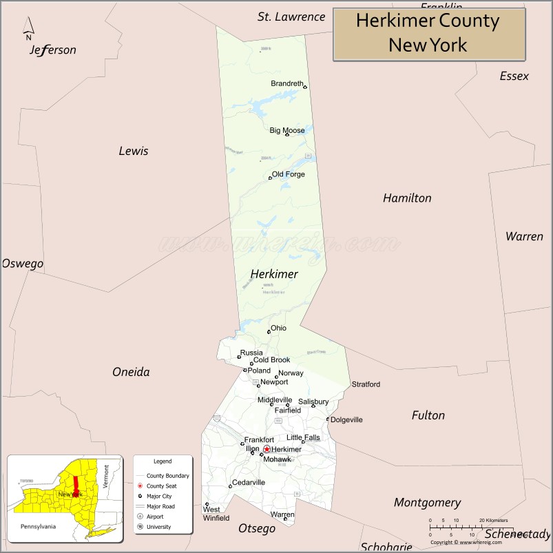
About Herkimer County Map, New York: The map showing the county boundary, county seat, major cities, highways, water bodies and neighbouring counties.
Related NY Maps & Info
About Herkimer County, New York
Herkimer County is a county located in the U.S. state of New York. It's county seat is Herkimer. As per 2020 census, the population of Herkimer County is 59937 people and population density is 41.11 square miles. According to the United States Census Bureau, the county has a total area of 1,458 sq mi (3,776 km2). Herkimer County was established on 1791.
Facts about Herkimer County, New York
| Country | United States |
| State | New York |
| Region | Mohawk Valley / Central New York |
| County Seat | Herkimer |
| Founded | 1791 |
| Named For | General Nicholas Herkimer (Revolutionary War hero) |
| Coordinates | 43.13° N, 74.99° W |
| Total Area | 1,458 sq mi |
| Land Area | 1,411 sq mi |
| Water Area | 46 sq mi |
| Water % | 3.2% |
| Population (2020) | 60,139 |
| Estimated Population (2024) | 59,600+ |
| Population Density | 42.6/sq mi |
| Largest Municipality | German Flatts (town) |
| Other Cities & Towns | Herkimer, Little Falls, Ilion, Frankfort, Dolgeville, Old Forge |
| Main Industries | Manufacturing, Agriculture, Services, Tourism |
| Major Highways | I‑90 (NYS Thruway), U.S. 20, NY‑5, NY‑28, NY‑29 |
| Time Zone | Eastern Time (UTC−05:00) |
| Known For | Herkimer “diamonds” (quartz crystals), Mohawk Valley, Adirondack access, Erie Canal heritage |
| Website | https://www.herkimercountyny.gov/ |
Top Attractions in Herkimer County, New York
- Herkimer Diamond Mines – Quartz crystal mining site.
- Erie Canal Village – Historic canal-era attraction.
- Fort Herkimer Church – 18th-century fortified church.
- Little Falls Canal Place – Erie Canal locks and trails.
- Herkimer Home State Historic Site – Revolutionary War-era home.
- Dolgeville Historic District – Historic village architecture.
- Mohawk Valley Railroad Museum – Rail history exhibits.
- Canada Creek Ranch (nearby) – Scenic wilderness area.
- Eastern Mohawk Valley Scenic Byway – Scenic driving route.
- Herkimer County Historical Society – Local history museum.
- Frankfort Gorge Falls – Small scenic waterfall.
- Canadarago Lake (nearby) – Fishing and boating lake.
Cities & Towns in Herkimer County, New York
Herkimer, Little Falls, Dolgeville (partly), Ilion, Mohawk, Newport, Poland, Frankfort, Schuyler, Fairfield, Newport Center, Norway, Warren, Russia, Schuyler Lake, Stark, Manheim, Norway Center, Middleville
- Albany County Map
- Allegany County Map
- Bronx County Map
- Broome County Map
- Cattaraugus County Map
- Cayuga County Map
- Chautauqua County Map
- Chemung County Map
- Chenango County Map
- Clinton County Map
- Columbia County Map
- Cortland County Map
- Delaware County Map
- Dutchess County Map
- Erie County Map
- Essex County Map
- Franklin County Map
- Fulton County Map
- Genesee County Map
- Greene County Map
- Hamilton County Map
- Herkimer County Map
- Jefferson County Map
- Kings County Map
- Lewis County Map
- Livingston County Map
- Madison County Map
- Monroe County Map
- Montgomery County Map
- Nassau County Map
- New York County Map
- Niagara County Map
- Oneida County Map
- Onondaga County Map
- Ontario County Map
- Orange County Map
- Orleans County Map
- Oswego County Map
- Otsego County Map
- Putnam County Map
- Queens County Map
- Rensselaer County Map
- Richmond County Map
- Rockland County Map
- St Lawrence County Map
- Saratoga County Map
- Schenectady County Map
- Schoharie County Map
- Schuyler County Map
- Seneca County Map
- Steuben County Map
- Suffolk County Map
- Sullivan County Map
- Tioga County Map
- Tompkins County Map
- Ulster County Map
- Warren County Map
- Washington County Map
- Wayne County Map
- Westchester County Map
- Wyoming County Map
- Yates County Map
- Alabama Counties
- Alaska boroughs
- Arizona Counties
- Arkansas Counties
- California County Map
- Colorado Counties
- Connecticut Counties
- Delaware Counties
- Florida County Map
- Georgia County Map
- Hawaii Counties
- Idaho Counties
- Illinois Counties
- Indiana Counties
- Iowa Counties
- Kansas Counties
- Kentucky Counties
- Louisiana Counties
- Maine Counties
- Maryland Counties
- Massachusetts Counties
- Michigan County Map
- Minnesota Counties
- Mississippi Counties
- Missouri Counties
- Montana Counties
- Nebraska Counties
- Nevada Counties
- New York Counties
- New Hampshire Counties
- New Jersey Counties
- New Mexico Counties
- North Carolina Counties
- North Dakota Counties
- Ohio County Map
- Oklahoma Counties
- Oregon Counties
- Pennsylvania Counties
- Rhode Island Counties
- South Carolina Counties
- South Dakota Counties
- Map of Tennessee
- Texas County Map
- Utah Counties
- Vermont Counties
- Virginia Counties
- Washington Counties
- West Virginia Counties
- Wisconsin Counties
- Wyoming Counties