Written and Fact-checked by Mukesh Kumar | Updated On: April 256 2026 | 15:50 ET
Map of Madison County - Madison County is a county located in the U.S. state of New York. Madison County Map showing cities, highways, important places and water bodies. Get Where is Madison County located in the map, major cities in Madison county, population, areas, and places of interest.
Map of Madison County, New York
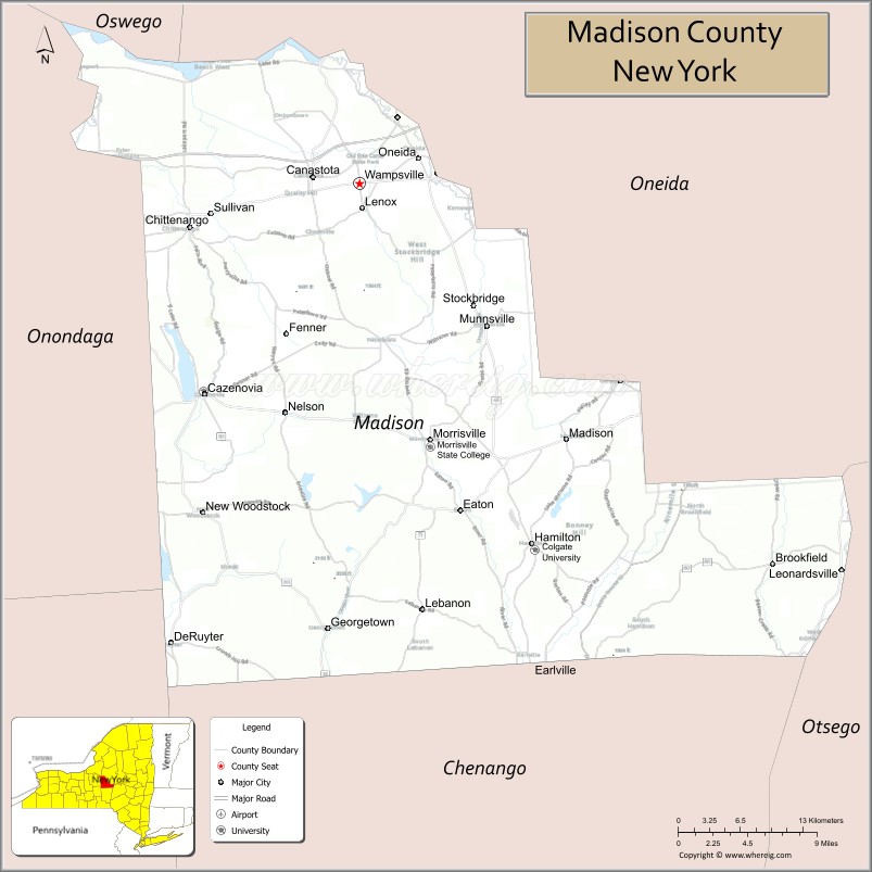
About Madison County Map, New York: The map showing the county boundary, county seat, major cities, highways, water bodies and neighbouring counties.
Related NY Maps & Info
About Madison County, New York
Madison County is a county located in the U.S. state of New York. It's county seat is Wampsville. As per 2020 census, the population of Madison County is 67658 people and population density is 102.2 square miles. According to the United States Census Bureau, the county has a total area of 662 sq mi (1,715 km2). Madison County was established on 1806.
Facts about Madison County, New York
| Country | United States |
| State | New York |
| Region | Central New York / Syracuse Metropolitan Area |
| County Seat | Wampsville |
| Founded | 1806 |
| Named For | James Madison (fourth U.S. President) |
| Coordinates | 42.95° N, 75.54° W |
| Total Area | 661 sq mi |
| Land Area | 655 sq mi |
| Water Area | 6.4 sq mi |
| Water % | 1.0% |
| Population (2020) | 68,016 |
| Estimated Population (2024) | 68,000+ |
| Population Density | 100/sq mi |
| Largest City | Oneida |
| Other Towns & Villages | Morrisville, Cazenovia, Canastota, Hamilton, Earlville, DeRuyter, Brookfield, Eaton, Fenner, Georgetown, Lebanon, Lenox, Lincoln, Madison, Nelson, Smithfield, Stockbridge, Sullivan |
| Main Industries | Agriculture (dairy, hops & beer, meat), Manufacturing, Education, Services, Renewable energy |
| Major Highways | U.S. 20, NY‑12B, NY‑26, NY‑46 |
| Time Zone | Eastern Time (UTC−05:00) |
| Known For | International Boxing Hall of Fame, National Abolition Hall of Fame & Museum, rural landscapes, close to Oneida Lake |
| Website | https://www.madisoncounty.ny.gov/ |
Top Attractions in Madison County, New York
- Erie Canal Village – Historic canal-era attraction.
- Chittenango Falls State Park – Tall scenic waterfall.
- Colgate University – Historic campus and arts.
- Cazenovia Lake – Boating and lakeside views.
- Cazenovia Historic District – Quaint village and shops.
- Madison County Courthouse – Historic government building.
- Chenango Canal Trail – Walking and biking trail.
- Owls Head Mountain (nearby) – Hiking and viewpoints.
- Stone Quarry Hill Art Park – Outdoor sculptures and trails.
- Lebanon Reservoir – Fishing and nature setting.
- Canastota Canal Town Museum – Canal history exhibits.
- Madison Bouckville Antique Center – Large antiques marketplace.
Cities & Towns in Madison County, New York
Oneida, Morrisville, Cazenovia, Chittenango, Canastota, Hamilton, Madison, Eaton, DeRuyter, Stockbridge, Lenox, Fenner, Smithfield, Brookfield, Georgetown, Nelson, Paris, Sullivan
- Albany County Map
- Allegany County Map
- Bronx County Map
- Broome County Map
- Cattaraugus County Map
- Cayuga County Map
- Chautauqua County Map
- Chemung County Map
- Chenango County Map
- Clinton County Map
- Columbia County Map
- Cortland County Map
- Delaware County Map
- Dutchess County Map
- Erie County Map
- Essex County Map
- Franklin County Map
- Fulton County Map
- Genesee County Map
- Greene County Map
- Hamilton County Map
- Herkimer County Map
- Jefferson County Map
- Kings County Map
- Lewis County Map
- Livingston County Map
- Madison County Map
- Monroe County Map
- Montgomery County Map
- Nassau County Map
- New York County Map
- Niagara County Map
- Oneida County Map
- Onondaga County Map
- Ontario County Map
- Orange County Map
- Orleans County Map
- Oswego County Map
- Otsego County Map
- Putnam County Map
- Queens County Map
- Rensselaer County Map
- Richmond County Map
- Rockland County Map
- St Lawrence County Map
- Saratoga County Map
- Schenectady County Map
- Schoharie County Map
- Schuyler County Map
- Seneca County Map
- Steuben County Map
- Suffolk County Map
- Sullivan County Map
- Tioga County Map
- Tompkins County Map
- Ulster County Map
- Warren County Map
- Washington County Map
- Wayne County Map
- Westchester County Map
- Wyoming County Map
- Yates County Map
- Alabama Counties
- Alaska boroughs
- Arizona Counties
- Arkansas Counties
- California County Map
- Colorado Counties
- Connecticut Counties
- Delaware Counties
- Florida County Map
- Georgia County Map
- Hawaii Counties
- Idaho Counties
- Illinois Counties
- Indiana Counties
- Iowa Counties
- Kansas Counties
- Kentucky Counties
- Louisiana Counties
- Maine Counties
- Maryland Counties
- Massachusetts Counties
- Michigan County Map
- Minnesota Counties
- Mississippi Counties
- Missouri Counties
- Montana Counties
- Nebraska Counties
- Nevada Counties
- New York Counties
- New Hampshire Counties
- New Jersey Counties
- New Mexico Counties
- North Carolina Counties
- North Dakota Counties
- Ohio County Map
- Oklahoma Counties
- Oregon Counties
- Pennsylvania Counties
- Rhode Island Counties
- South Carolina Counties
- South Dakota Counties
- Map of Tennessee
- Texas County Map
- Utah Counties
- Vermont Counties
- Virginia Counties
- Washington Counties
- West Virginia Counties
- Wisconsin Counties
- Wyoming Counties