Written and Fact-checked by Mukesh Kumar | Updated On: April 256 2026 | 15:50 ET
Map of Wyoming County - Wyoming County is a county located in the U.S. state of New York. Wyoming County Map showing cities, highways, important places and water bodies. Get Where is Wyoming County located in the map, major cities in Wyoming county, population, areas, and places of interest.
Map of Wyoming County, New York
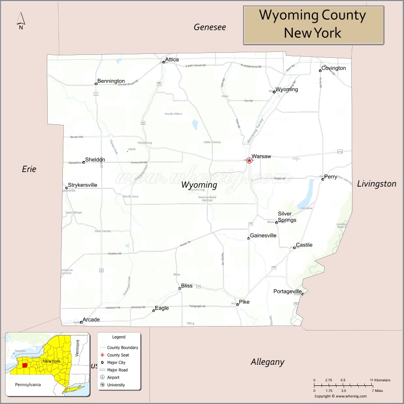
About Wyoming County Map, New York: The map showing the county boundary, county seat, major cities, highways, water bodies and neighbouring counties.
Related NY Maps & Info
About Wyoming County, New York
Wyoming County is a county located in the U.S. state of New York. It's county seat is Warsaw. As per 2020 census, the population of Wyoming County is 40491 people and population density is 67.94 square miles. According to the United States Census Bureau, the county has a total area of 596 sq mi (1,544 km2). Wyoming County was established on 1841.
Facts about Wyoming County, New York
| Country | United States |
| State | New York |
| Region | Western New York / Finger Lakes area |
| County Seat | Warsaw |
| Founded | 1841 |
| Named For | Modified Lenape (Delaware) word meaning “broad bottom lands” |
| Coordinates | 42.73° N, 78.17° W |
| Total Area | 596 sq mi |
| Land Area | 593 sq mi |
| Water Area | 3.5 sq mi |
| Water % | 0.6% |
| Population (2020) | 40,531 |
| Estimated Population (2024) | 40,000+ |
| Population Density | 68/sq mi |
| Largest Municipality | Warsaw (village) |
| Other Towns & Communities | Perry, Arcade, Attica, Gainesville, Castile, Covington, Middlebury, Genesee Falls, Pike, Wethersfield |
| Main Industries | Agriculture (especially dairy), Manufacturing, Tourism, Salt mining |
| Major Highways | NY‑19, NY‑39, NY‑63, NY‑77, NY‑78 |
| Time Zone | Eastern Time (UTC−05:00) |
| Known For | Letchworth State Park (“Grand Canyon of the East”), rural landscapes, farming & outdoor recreation |
| Website | https://www.wyomingco.net/ |
Top Attractions in Wyoming County, New York
- Letchworth State Park (nearby) – Gorge views and waterfalls.
- Silver Lake – Boating and lakeside recreation.
- Arcade & Attica Railroad – Scenic vintage train rides.
- Warsaw Village Park – Downtown green space.
- Wyoming County Fairgrounds – Annual fair and events.
- Bennington Battlefield State Historic Site – Revolutionary War history.
- Perry Public Square – Shops and village center.
- Wyoming County Historical Society – Local history exhibits.
- Middle Falls – Scenic waterfall on Silver Lake.
- Oatka Creek – Fishing and paddling.
- East Hill State Forest – Forest trails and nature.
- Attica Village Historic Area – Historic architecture.
Cities & Towns in Wyoming County, New York
Warsaw, Attica, Arcade, Perry, Silver Springs, Castile, Gainesville, Middlebury, Sheldon, Bennington, Covington, Orangeville, Java, Eagle, Wethersfield, Arcade Center
- Albany County Map
- Allegany County Map
- Bronx County Map
- Broome County Map
- Cattaraugus County Map
- Cayuga County Map
- Chautauqua County Map
- Chemung County Map
- Chenango County Map
- Clinton County Map
- Columbia County Map
- Cortland County Map
- Delaware County Map
- Dutchess County Map
- Erie County Map
- Essex County Map
- Franklin County Map
- Fulton County Map
- Genesee County Map
- Greene County Map
- Hamilton County Map
- Herkimer County Map
- Jefferson County Map
- Kings County Map
- Lewis County Map
- Livingston County Map
- Madison County Map
- Monroe County Map
- Montgomery County Map
- Nassau County Map
- New York County Map
- Niagara County Map
- Oneida County Map
- Onondaga County Map
- Ontario County Map
- Orange County Map
- Orleans County Map
- Oswego County Map
- Otsego County Map
- Putnam County Map
- Queens County Map
- Rensselaer County Map
- Richmond County Map
- Rockland County Map
- St Lawrence County Map
- Saratoga County Map
- Schenectady County Map
- Schoharie County Map
- Schuyler County Map
- Seneca County Map
- Steuben County Map
- Suffolk County Map
- Sullivan County Map
- Tioga County Map
- Tompkins County Map
- Ulster County Map
- Warren County Map
- Washington County Map
- Wayne County Map
- Westchester County Map
- Wyoming County Map
- Yates County Map
- Alabama Counties
- Alaska boroughs
- Arizona Counties
- Arkansas Counties
- California County Map
- Colorado Counties
- Connecticut Counties
- Delaware Counties
- Florida County Map
- Georgia County Map
- Hawaii Counties
- Idaho Counties
- Illinois Counties
- Indiana Counties
- Iowa Counties
- Kansas Counties
- Kentucky Counties
- Louisiana Counties
- Maine Counties
- Maryland Counties
- Massachusetts Counties
- Michigan County Map
- Minnesota Counties
- Mississippi Counties
- Missouri Counties
- Montana Counties
- Nebraska Counties
- Nevada Counties
- New York Counties
- New Hampshire Counties
- New Jersey Counties
- New Mexico Counties
- North Carolina Counties
- North Dakota Counties
- Ohio County Map
- Oklahoma Counties
- Oregon Counties
- Pennsylvania Counties
- Rhode Island Counties
- South Carolina Counties
- South Dakota Counties
- Map of Tennessee
- Texas County Map
- Utah Counties
- Vermont Counties
- Virginia Counties
- Washington Counties
- West Virginia Counties
- Wisconsin Counties
- Wyoming Counties