Written and Fact-checked by Mukesh Kumar | Updated On: April 256 2026 | 15:50 ET
Map of Monroe County - Monroe County is a county located in the U.S. state of New York. Monroe County Map showing cities, highways, important places and water bodies. Get Where is Monroe County located in the map, major cities in Monroe county, population, areas, and places of interest.
Map of Monroe County, New York
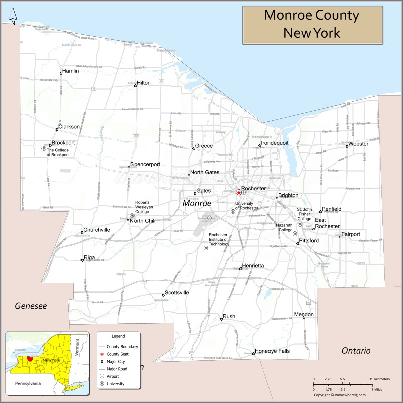
About Monroe County Map, New York: The map showing the county boundary, county seat, major cities, highways, water bodies and neighbouring counties.
Related NY Maps & Info
About Monroe County, New York
Monroe County is a county located in the U.S. state of New York. It's county seat is Rochester. As per 2020 census, the population of Monroe County is 755160 people and population density is 552.83 square miles. According to the United States Census Bureau, the county has a total area of 1,366 sq mi (3,538 km2). Monroe County was established on 1821.
Facts about Monroe County, New York
| Country | United States |
| State | New York |
| Region | Western New York / Lake Ontario & Finger Lakes area |
| County Seat | Rochester |
| Founded | February 23, 1821 |
| Named For | James Monroe (fifth U.S. President) |
| Coordinates | 43.15° N, 77.62° W |
| Total Area | 1,367 sq mi |
| Land Area | 657 sq mi |
| Water Area | 710 sq mi |
| Water % | 52% |
| Population (2020) | 759,443 |
| Estimated Population (2024) | 752,200+ |
| Population Density | 1,156/sq mi (land area) |
| Largest City | Rochester |
| Other Major Communities | Greece, Irondequoit, Henrietta, Webster, Penfield, Pittsford |
| Main Industries | Services, Healthcare, Education, Manufacturing, Technology |
| Major Highways | I‑90, I‑490, NY‑390, U.S. 20, NY‑104 |
| Time Zone | Eastern Time (UTC−05:00) |
| Known For | Rochester’s cultural institutions, Lake Ontario shoreline, Genesee River, educational & research centers |
| Website | https://www.monroecounty.gov/ |
Top Attractions in Monroe County, New York
- Strong National Museum of Play – Interactive family museum.
- George Eastman Museum – Photography and film history.
- Highland Park – Scenic park with lilac festival.
- Genesee Riverway Trail – Urban walking and biking trail.
- Seabreeze Amusement Park – Classic lakeside rides.
- Ontario Beach Park – Lake Ontario waterfront park.
- Rochester Museum & Science Center – Science and cultural exhibits.
- Eastman Theatre – Performing arts venue.
- Mount Hope Cemetery – Historic cemetery and arboretum.
- Seneca Park Zoo – Lakeside zoo.
- Memorial Art Gallery – Fine art collections.
- Erie Canal Heritage Trail – Historic canal path.
Cities & Towns in Monroe County, New York
Rochester, Greece, Irondequoit, Brighton, Webster, Gates, Henrietta, Penfield, Chili, Fairport, Pittsford, East Rochester, Macedon, Victor, Hamlin, Mendon, Ogden, Parma, Rush, Sweden
- Albany County Map
- Allegany County Map
- Bronx County Map
- Broome County Map
- Cattaraugus County Map
- Cayuga County Map
- Chautauqua County Map
- Chemung County Map
- Chenango County Map
- Clinton County Map
- Columbia County Map
- Cortland County Map
- Delaware County Map
- Dutchess County Map
- Erie County Map
- Essex County Map
- Franklin County Map
- Fulton County Map
- Genesee County Map
- Greene County Map
- Hamilton County Map
- Herkimer County Map
- Jefferson County Map
- Kings County Map
- Lewis County Map
- Livingston County Map
- Madison County Map
- Monroe County Map
- Montgomery County Map
- Nassau County Map
- New York County Map
- Niagara County Map
- Oneida County Map
- Onondaga County Map
- Ontario County Map
- Orange County Map
- Orleans County Map
- Oswego County Map
- Otsego County Map
- Putnam County Map
- Queens County Map
- Rensselaer County Map
- Richmond County Map
- Rockland County Map
- St Lawrence County Map
- Saratoga County Map
- Schenectady County Map
- Schoharie County Map
- Schuyler County Map
- Seneca County Map
- Steuben County Map
- Suffolk County Map
- Sullivan County Map
- Tioga County Map
- Tompkins County Map
- Ulster County Map
- Warren County Map
- Washington County Map
- Wayne County Map
- Westchester County Map
- Wyoming County Map
- Yates County Map
- Alabama Counties
- Alaska boroughs
- Arizona Counties
- Arkansas Counties
- California County Map
- Colorado Counties
- Connecticut Counties
- Delaware Counties
- Florida County Map
- Georgia County Map
- Hawaii Counties
- Idaho Counties
- Illinois Counties
- Indiana Counties
- Iowa Counties
- Kansas Counties
- Kentucky Counties
- Louisiana Counties
- Maine Counties
- Maryland Counties
- Massachusetts Counties
- Michigan County Map
- Minnesota Counties
- Mississippi Counties
- Missouri Counties
- Montana Counties
- Nebraska Counties
- Nevada Counties
- New York Counties
- New Hampshire Counties
- New Jersey Counties
- New Mexico Counties
- North Carolina Counties
- North Dakota Counties
- Ohio County Map
- Oklahoma Counties
- Oregon Counties
- Pennsylvania Counties
- Rhode Island Counties
- South Carolina Counties
- South Dakota Counties
- Map of Tennessee
- Texas County Map
- Utah Counties
- Vermont Counties
- Virginia Counties
- Washington Counties
- West Virginia Counties
- Wisconsin Counties
- Wyoming Counties