Written and Fact-checked by Mukesh Kumar | Updated On: April 256 2026 | 15:50 ET
Map of Greene County - Greene County is a county located in the U.S. state of New York. Greene County Map showing cities, highways, important places and water bodies. Get Where is Greene County located in the map, major cities in Greene county, population, areas, and places of interest.
Map of Greene County, New York
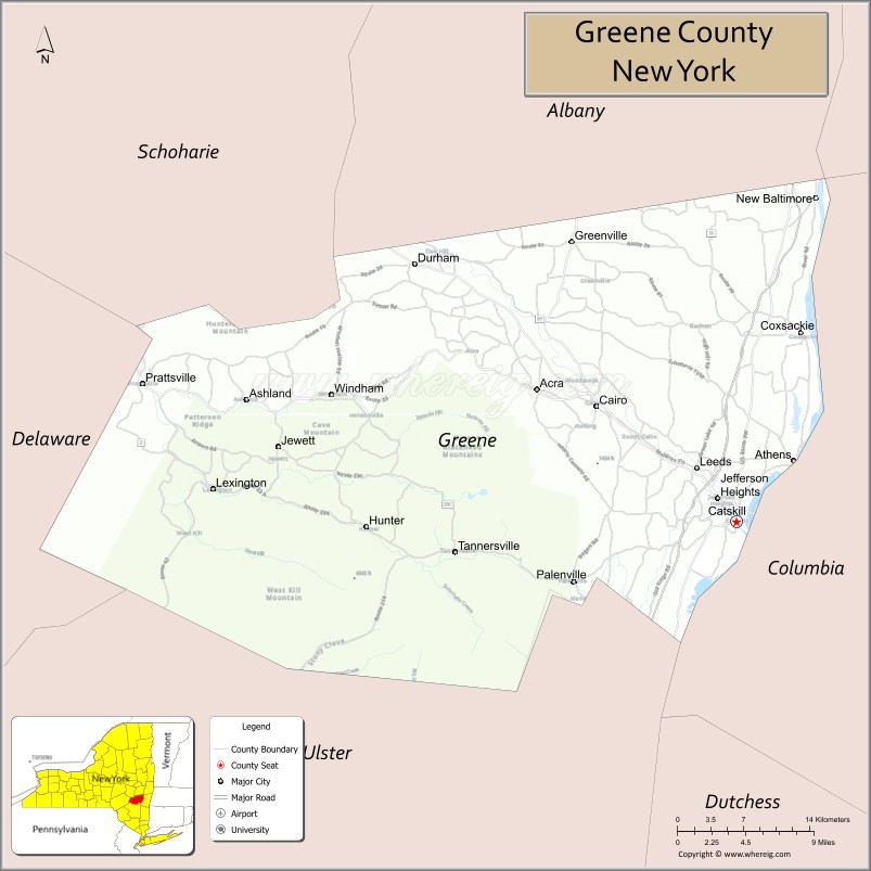
About Greene County Map, New York: The map showing the county boundary, county seat, major cities, highways, water bodies and neighbouring counties.
Related NY Maps & Info
About Greene County, New York
Greene County is a county located in the U.S. state of New York. It's county seat is Catskill. As per 2020 census, the population of Greene County is 48499 people and population density is 73.71 square miles. According to the United States Census Bureau, the county has a total area of 658 sq mi (1,704 km2). Greene County was established on 1800.
Facts about Greene County, New York
| Country | United States |
| State | New York |
| Region | Hudson Valley / Catskill Mountains (North Country) |
| County Seat | Catskill |
| Founded | March 25, 1800 |
| Named For | General Nathanael Greene (Revolutionary War leader) |
| Coordinates | 42.29° N, 74.15° W |
| Total Area | 648 sq mi |
| Land Area | 638 sq mi |
| Water Area | 10 sq mi |
| Water % | 1.5% |
| Population (2020) | 47,931 |
| Estimated Population (2024) | 47,000+ |
| Population Density | 75/sq mi |
| Largest Municipality | Catskill |
| Other Towns & Villages | Athens, Coxsackie, Cairo, Hunter, Tannersville, Windham |
| Main Industries | Tourism, Outdoor recreation, Services, Agriculture |
| Major Highways | I‑87 (NYS Thruway), U.S. 9W, NY‑23, NY‑32, NY‑145, NY‑214 |
| Time Zone | Eastern Time (UTC−05:00) |
| Known For | Catskill Mountains, Hudson River Valley scenery, Kaaterskill Falls, Thomas Cole National Historic Site |
| Website | https://greenecountyny.gov/ |
Top Attractions in Greene County, New York
- Catskill Mountains – Scenic peaks and outdoor recreation.
- Hunter Mountain – Skiing and summer festivals.
- Kaaterskill Falls – Iconic two-tier waterfall.
- North-South Lake Campground – Hiking and lake views.
- Olana State Historic Site (nearby) – Historic artist’s estate.
- Thomas Cole National Historic Site – Hudson River School history.
- Rip Van Winkle Bridge – Scenic Hudson River crossing.
- Windham Mountain – Ski resort and outdoor activities.
- Mountain Top Arboretum – Gardens and nature trails.
- Greene County Historical Society – Local history exhibits.
- Hudson River Skywalk (nearby) – Pedestrian bridge with views.
- Durham Valley Scenic Area – Rural landscapes and trails.
Cities & Towns in Greene County, New York
Catskill, Hunter, Tannersville, Cairo, Windham, Jewett, Lexington, Prattsville, Greenville, Haines Falls, Ashland, Jewett Center, Coxsackie (partly), Lexington Center
- Albany County Map
- Allegany County Map
- Bronx County Map
- Broome County Map
- Cattaraugus County Map
- Cayuga County Map
- Chautauqua County Map
- Chemung County Map
- Chenango County Map
- Clinton County Map
- Columbia County Map
- Cortland County Map
- Delaware County Map
- Dutchess County Map
- Erie County Map
- Essex County Map
- Franklin County Map
- Fulton County Map
- Genesee County Map
- Greene County Map
- Hamilton County Map
- Herkimer County Map
- Jefferson County Map
- Kings County Map
- Lewis County Map
- Livingston County Map
- Madison County Map
- Monroe County Map
- Montgomery County Map
- Nassau County Map
- New York County Map
- Niagara County Map
- Oneida County Map
- Onondaga County Map
- Ontario County Map
- Orange County Map
- Orleans County Map
- Oswego County Map
- Otsego County Map
- Putnam County Map
- Queens County Map
- Rensselaer County Map
- Richmond County Map
- Rockland County Map
- St Lawrence County Map
- Saratoga County Map
- Schenectady County Map
- Schoharie County Map
- Schuyler County Map
- Seneca County Map
- Steuben County Map
- Suffolk County Map
- Sullivan County Map
- Tioga County Map
- Tompkins County Map
- Ulster County Map
- Warren County Map
- Washington County Map
- Wayne County Map
- Westchester County Map
- Wyoming County Map
- Yates County Map
- Alabama Counties
- Alaska boroughs
- Arizona Counties
- Arkansas Counties
- California County Map
- Colorado Counties
- Connecticut Counties
- Delaware Counties
- Florida County Map
- Georgia County Map
- Hawaii Counties
- Idaho Counties
- Illinois Counties
- Indiana Counties
- Iowa Counties
- Kansas Counties
- Kentucky Counties
- Louisiana Counties
- Maine Counties
- Maryland Counties
- Massachusetts Counties
- Michigan County Map
- Minnesota Counties
- Mississippi Counties
- Missouri Counties
- Montana Counties
- Nebraska Counties
- Nevada Counties
- New York Counties
- New Hampshire Counties
- New Jersey Counties
- New Mexico Counties
- North Carolina Counties
- North Dakota Counties
- Ohio County Map
- Oklahoma Counties
- Oregon Counties
- Pennsylvania Counties
- Rhode Island Counties
- South Carolina Counties
- South Dakota Counties
- Map of Tennessee
- Texas County Map
- Utah Counties
- Vermont Counties
- Virginia Counties
- Washington Counties
- West Virginia Counties
- Wisconsin Counties
- Wyoming Counties