Written and Fact-checked by Mukesh Kumar | Updated On: April 256 2026 | 15:50 ET
Map of Cayuga County - Cayuga County is a county located in the U.S. state of New York. Cayuga County Map showing cities, highways, important places and water bodies. Get Where is Cayuga County located in the map, major cities in Cayuga county, population, areas, and places of interest.
Map of Cayuga County, New York
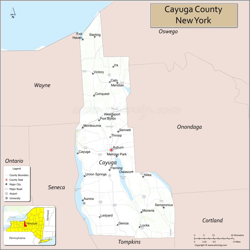
About Cayuga County Map, New York: The map showing the county boundary, county seat, major cities, highways, water bodies and neighbouring counties.
Related NY Maps & Info
About Cayuga County, New York
Cayuga County is a county located in the U.S. state of New York. It's county seat is Auburn. As per 2020 census, the population of Cayuga County is 75880 people and population density is 87.82 square miles. According to the United States Census Bureau, the county has a total area of 864 sq mi (2,238 km2). Cayuga County was established on 1799.
Facts about Cayuga County, New York
| Country | United States |
| State | New York |
| Region | Central New York / Finger Lakes |
| County Seat | Auburn |
| Founded | 1799 |
| Named For | Cayuga people (Iroquois Confederation tribe) |
| Coordinates | 42.22° N, 78.03° W |
| Total Area | 864 sq mi |
| Land Area | 692 sq mi |
| Water Area | 172 sq mi |
| Water % | 20% |
| Population (2020) | 76,248 |
| Estimated Population (2025) | 74,559 |
| Population Density | 110/sq mi |
| Largest City | Auburn |
| Other Communities | Union Springs, Moravia, Weedsport, Fair Haven, Cato, Aurora |
| Main Industries | Agriculture, Manufacturing, Services, Education |
| Major Highways | I‑90 (NY State Thruway), U.S. 20, NY‑5, NY‑31, NY‑34, NY‑38, NY‑90 |
| Time Zone | Eastern Time (UTC−05:00) |
| Known For | Finger Lakes scenery (Cayuga & Owasco Lakes), historic Auburn, Montezuma National Wildlife Refuge |
| Website | https://www.cayugacounty.gov/ |
Top Attractions in Cayuga County, New York
- Montezuma National Wildlife Refuge – Wetlands and birdwatching.
- Cayuga Lake – Boating, fishing, and lakeside views.
- Harriet Tubman National Historical Park – Underground Railroad history site.
- Emerson Park – Lakeside park and marina.
- Howland Stone Store Museum – Historic abolitionist site.
- Fort Hill Cemetery – Burial site of Harriet Tubman.
- Ward W. O’Hara Agricultural Museum – Farming history exhibits.
- Schweinfurth Art Center – Contemporary and folk art.
- Aurora Village–Wells College Area – Historic village setting.
- Frontenac Park – Scenic park on Cayuga Lake.
- Long Point State Park – Swimming and picnic park.
- Willard Memorial Chapel – Tiffany-designed chapel.
Cities & Towns in Cayuga County, New York
Auburn, Port Byron, Weedsport, Moravia, Cayuga, Meridian, Union Springs, Aurelius, Genoa, Locke, Ledyard, Summerhill, Venice, Sterling, Sempronius, Scipio, Niles, Fleming, Conquest, Brutus, Mentz
- Albany County Map
- Allegany County Map
- Bronx County Map
- Broome County Map
- Cattaraugus County Map
- Cayuga County Map
- Chautauqua County Map
- Chemung County Map
- Chenango County Map
- Clinton County Map
- Columbia County Map
- Cortland County Map
- Delaware County Map
- Dutchess County Map
- Erie County Map
- Essex County Map
- Franklin County Map
- Fulton County Map
- Genesee County Map
- Greene County Map
- Hamilton County Map
- Herkimer County Map
- Jefferson County Map
- Kings County Map
- Lewis County Map
- Livingston County Map
- Madison County Map
- Monroe County Map
- Montgomery County Map
- Nassau County Map
- New York County Map
- Niagara County Map
- Oneida County Map
- Onondaga County Map
- Ontario County Map
- Orange County Map
- Orleans County Map
- Oswego County Map
- Otsego County Map
- Putnam County Map
- Queens County Map
- Rensselaer County Map
- Richmond County Map
- Rockland County Map
- St Lawrence County Map
- Saratoga County Map
- Schenectady County Map
- Schoharie County Map
- Schuyler County Map
- Seneca County Map
- Steuben County Map
- Suffolk County Map
- Sullivan County Map
- Tioga County Map
- Tompkins County Map
- Ulster County Map
- Warren County Map
- Washington County Map
- Wayne County Map
- Westchester County Map
- Wyoming County Map
- Yates County Map
- Alabama Counties
- Alaska boroughs
- Arizona Counties
- Arkansas Counties
- California County Map
- Colorado Counties
- Connecticut Counties
- Delaware Counties
- Florida County Map
- Georgia County Map
- Hawaii Counties
- Idaho Counties
- Illinois Counties
- Indiana Counties
- Iowa Counties
- Kansas Counties
- Kentucky Counties
- Louisiana Counties
- Maine Counties
- Maryland Counties
- Massachusetts Counties
- Michigan County Map
- Minnesota Counties
- Mississippi Counties
- Missouri Counties
- Montana Counties
- Nebraska Counties
- Nevada Counties
- New York Counties
- New Hampshire Counties
- New Jersey Counties
- New Mexico Counties
- North Carolina Counties
- North Dakota Counties
- Ohio County Map
- Oklahoma Counties
- Oregon Counties
- Pennsylvania Counties
- Rhode Island Counties
- South Carolina Counties
- South Dakota Counties
- Map of Tennessee
- Texas County Map
- Utah Counties
- Vermont Counties
- Virginia Counties
- Washington Counties
- West Virginia Counties
- Wisconsin Counties
- Wyoming Counties