Written and Fact-checked by Mukesh Kumar | Updated On: April 256 2026 | 15:50 ET
Map of Oneida County - Oneida County is a county located in the U.S. state of New York. Oneida County Map showing cities, highways, important places and water bodies. Get Where is Oneida County located in the map, major cities in Oneida county, population, areas, and places of interest.
Map of Oneida County, New York
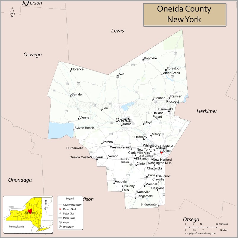
About Oneida County Map, New York: The map showing the county boundary, county seat, major cities, highways, water bodies and neighbouring counties.
Related NY Maps & Info
About Oneida County, New York
Oneida County is a county located in the U.S. state of New York. It's county seat is Utica. As per 2020 census, the population of Oneida County is 230274 people and population density is 189.84 square miles. According to the United States Census Bureau, the county has a total area of 1,213 sq mi (3,142 km2). Oneida County was established on 1798.
Facts about Oneida County, New York
| Country | United States |
| State | New York |
| Region | Central New York / Mohawk Valley |
| County Seat | Utica |
| Founded | March 15, 1798 |
| Named For | Oneida people (Iroquois Confederacy tribe) |
| Coordinates | 43.10° N, 75.23° W |
| Total Area | 1,258 sq mi |
| Land Area | 1,212 sq mi |
| Water Area | 45 sq mi |
| Water % | 3.6% |
| Population (2020) | 232,125 |
| Estimated Population (2024) | 228,347 |
| Population Density | 188/sq mi |
| Largest City | Utica |
| Other Cities & Towns | Rome, New Hartford, Oneida Castle, Whitestown, Vernon, Oriskany |
| Main Industries | Manufacturing, Services, Healthcare, Education, Tourism (casino & historic sites) |
| Major Highways | I‑90, NY‑5, NY‑12, NY‑46, NY‑365 |
| Time Zone | Eastern Time (UTC−05:00) |
| Known For | Erie Canal heritage, Fort Stanwix National Monument, Turning Stone Resort & Casino, Mohawk Valley culture |
| Website | https://oneidacountyny.gov/ |
Top Attractions in Oneida County, New York
- Turning Stone Resort Casino – Gaming and entertainment complex.
- Utica Zoo – Family-friendly animal exhibits.
- Fort Stanwix National Monument – Revolutionary War fort.
- Munson-Williams-Proctor Arts Institute – Art museum and performances.
- Stanley Theatre – Historic performing arts venue.
- Delta Lake State Park – Camping and lake recreation.
- Erie Canalway Trail – Historic walking and biking trail.
- Utica Marsh Wildlife Management Area – Boardwalk trails and birds.
- Old Forge (nearby) – Adirondack village gateway.
- Herkimer Diamond Mines (nearby) – Crystal mining experience.
- New York State Zoo at Thompson Park – Regional wildlife exhibits.
- Rome Historical Society Museum – Local history displays.
Cities & Towns in Oneida County, New York
Utica, Rome, New Hartford, Sherrill, Whitesboro, Oriskany, Vernon, Oneida, Oneida Castle, Boonville, Waterville, Sylvan Beach, Holland Patent, Marcy, Forestport, Remsen, Ava, Bridgewater, Western
- Albany County Map
- Allegany County Map
- Bronx County Map
- Broome County Map
- Cattaraugus County Map
- Cayuga County Map
- Chautauqua County Map
- Chemung County Map
- Chenango County Map
- Clinton County Map
- Columbia County Map
- Cortland County Map
- Delaware County Map
- Dutchess County Map
- Erie County Map
- Essex County Map
- Franklin County Map
- Fulton County Map
- Genesee County Map
- Greene County Map
- Hamilton County Map
- Herkimer County Map
- Jefferson County Map
- Kings County Map
- Lewis County Map
- Livingston County Map
- Madison County Map
- Monroe County Map
- Montgomery County Map
- Nassau County Map
- New York County Map
- Niagara County Map
- Oneida County Map
- Onondaga County Map
- Ontario County Map
- Orange County Map
- Orleans County Map
- Oswego County Map
- Otsego County Map
- Putnam County Map
- Queens County Map
- Rensselaer County Map
- Richmond County Map
- Rockland County Map
- St Lawrence County Map
- Saratoga County Map
- Schenectady County Map
- Schoharie County Map
- Schuyler County Map
- Seneca County Map
- Steuben County Map
- Suffolk County Map
- Sullivan County Map
- Tioga County Map
- Tompkins County Map
- Ulster County Map
- Warren County Map
- Washington County Map
- Wayne County Map
- Westchester County Map
- Wyoming County Map
- Yates County Map
- Alabama Counties
- Alaska boroughs
- Arizona Counties
- Arkansas Counties
- California County Map
- Colorado Counties
- Connecticut Counties
- Delaware Counties
- Florida County Map
- Georgia County Map
- Hawaii Counties
- Idaho Counties
- Illinois Counties
- Indiana Counties
- Iowa Counties
- Kansas Counties
- Kentucky Counties
- Louisiana Counties
- Maine Counties
- Maryland Counties
- Massachusetts Counties
- Michigan County Map
- Minnesota Counties
- Mississippi Counties
- Missouri Counties
- Montana Counties
- Nebraska Counties
- Nevada Counties
- New York Counties
- New Hampshire Counties
- New Jersey Counties
- New Mexico Counties
- North Carolina Counties
- North Dakota Counties
- Ohio County Map
- Oklahoma Counties
- Oregon Counties
- Pennsylvania Counties
- Rhode Island Counties
- South Carolina Counties
- South Dakota Counties
- Map of Tennessee
- Texas County Map
- Utah Counties
- Vermont Counties
- Virginia Counties
- Washington Counties
- West Virginia Counties
- Wisconsin Counties
- Wyoming Counties