Written and Fact-checked by Mukesh Kumar | Updated On: April 256 2026 | 15:50 ET
Map of Chenango County - Chenango County is a county located in the U.S. state of New York. Chenango County Map showing cities, highways, important places and water bodies. Get Where is Chenango County located in the map, major cities in Chenango county, population, areas, and places of interest.
Map of Chenango County, New York
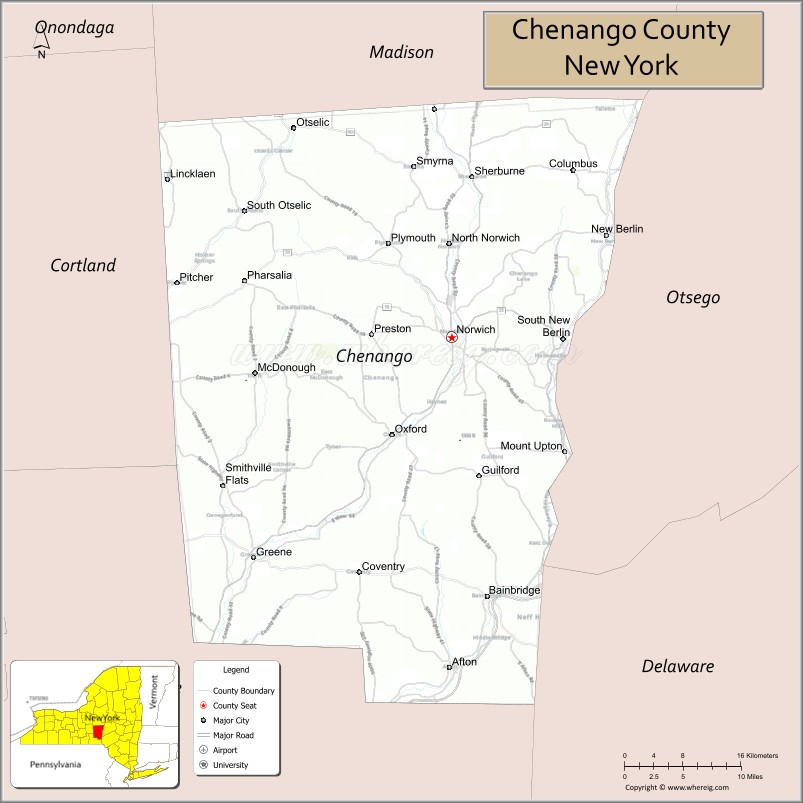
About Chenango County Map, New York: The map showing the county boundary, county seat, major cities, highways, water bodies and neighbouring counties.
Related NY Maps & Info
About Chenango County, New York
Chenango County is a county located in the U.S. state of New York. It's county seat is Norwich. As per 2020 census, the population of Chenango County is 46537 people and population density is 51.77 square miles. According to the United States Census Bureau, the county has a total area of 898.85 sq mi (2,328 km2). Chenango County was established on 1798.
Facts about Chenango County, New York
| Country | United States |
| State | New York |
| Region | Southern Tier / Central New York |
| County Seat | Norwich |
| Founded | March 15, 1798 |
| Named For | Oneida word for “bull thistle” (natural plant) |
| Coordinates | 42.55° N, 75.52° W |
| Total Area | 899 sq mi |
| Land Area | 894 sq mi |
| Water Area | 5.1 sq mi |
| Water % | 0.6% |
| Population (2020) | 47,220 |
| Estimated Population (2024) | 45,776 |
| Population Density | 53/sq mi |
| Largest City | Norwich |
| Other Communities | Greene, Oxford, Sherburne, Bainbridge, New Berlin, Afton |
| Main Industries | Agriculture, Manufacturing, Services, Tourism |
| Major Highways | NY‑12, NY‑23, NY‑26, NY‑41, NY‑51 |
| Time Zone | Eastern Time (UTC−05:00) |
| Known For | Rural landscapes, Chenango River, outdoor recreation and small‑town character |
| Website | https://www.chenangocountyny.gov/ |
Top Attractions in Chenango County, New York
- Chenango Valley State Park – Hiking, camping, and lake recreation.
- Northeast Classic Car Museum – Vintage and classic automobiles.
- Bowman Lake State Park – Swimming, fishing, and picnicking.
- Genegantslet Greenway – Scenic trail for hiking and biking.
- Oxford Village Historic District – Historic buildings and shops.
- Norwich Pharmacal Company Museum – Local industrial history.
- Blue Stone Quarry Falls Park – Small park with waterfall.
- Chenango Arts Council – Local art exhibitions and events.
- Whaupaunaucau State Forest – Forest trails and wildlife.
- Roger Follett Memorial Forest – Nature walks and scenery.
- Downtown Norwich – Dining, shops, and local culture.
- Canasawacta Country Club Area – Golf and recreation setting.
Cities & Towns in Chenango County, New York
Norwich, Greene, New Berlin, Oxford, Sherburne, Bainbridge, Columbus, Chenango, Fenton, Coventry, Plymouth, Smyrna, Afton, German, Pharsalia, Coventryville, Earlville
- Albany County Map
- Allegany County Map
- Bronx County Map
- Broome County Map
- Cattaraugus County Map
- Cayuga County Map
- Chautauqua County Map
- Chemung County Map
- Chenango County Map
- Clinton County Map
- Columbia County Map
- Cortland County Map
- Delaware County Map
- Dutchess County Map
- Erie County Map
- Essex County Map
- Franklin County Map
- Fulton County Map
- Genesee County Map
- Greene County Map
- Hamilton County Map
- Herkimer County Map
- Jefferson County Map
- Kings County Map
- Lewis County Map
- Livingston County Map
- Madison County Map
- Monroe County Map
- Montgomery County Map
- Nassau County Map
- New York County Map
- Niagara County Map
- Oneida County Map
- Onondaga County Map
- Ontario County Map
- Orange County Map
- Orleans County Map
- Oswego County Map
- Otsego County Map
- Putnam County Map
- Queens County Map
- Rensselaer County Map
- Richmond County Map
- Rockland County Map
- St Lawrence County Map
- Saratoga County Map
- Schenectady County Map
- Schoharie County Map
- Schuyler County Map
- Seneca County Map
- Steuben County Map
- Suffolk County Map
- Sullivan County Map
- Tioga County Map
- Tompkins County Map
- Ulster County Map
- Warren County Map
- Washington County Map
- Wayne County Map
- Westchester County Map
- Wyoming County Map
- Yates County Map
- Alabama Counties
- Alaska boroughs
- Arizona Counties
- Arkansas Counties
- California County Map
- Colorado Counties
- Connecticut Counties
- Delaware Counties
- Florida County Map
- Georgia County Map
- Hawaii Counties
- Idaho Counties
- Illinois Counties
- Indiana Counties
- Iowa Counties
- Kansas Counties
- Kentucky Counties
- Louisiana Counties
- Maine Counties
- Maryland Counties
- Massachusetts Counties
- Michigan County Map
- Minnesota Counties
- Mississippi Counties
- Missouri Counties
- Montana Counties
- Nebraska Counties
- Nevada Counties
- New York Counties
- New Hampshire Counties
- New Jersey Counties
- New Mexico Counties
- North Carolina Counties
- North Dakota Counties
- Ohio County Map
- Oklahoma Counties
- Oregon Counties
- Pennsylvania Counties
- Rhode Island Counties
- South Carolina Counties
- South Dakota Counties
- Map of Tennessee
- Texas County Map
- Utah Counties
- Vermont Counties
- Virginia Counties
- Washington Counties
- West Virginia Counties
- Wisconsin Counties
- Wyoming Counties