Written and Fact-checked by Mukesh Kumar | Updated On: April 256 2026 | 15:50 ET
Map of Delaware County - Delaware County is a county located in the U.S. state of New York. Delaware County Map showing cities, highways, important places and water bodies. Get Where is Delaware County located in the map, major cities in Delaware county, population, areas, and places of interest.
Map of Delaware County, New York
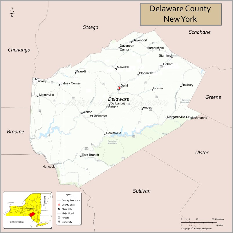
About Delaware County Map, New York: The map showing the county boundary, county seat, major cities, highways, water bodies and neighbouring counties.
Related NY Maps & Info
About Delaware County, New York
Greene County is a county located in the U.S. state of New York. It`s county seat is Catskill. As per 2020 census, the population of Greene County was 48499 and population density of Greene was 73.71square miles. According to the United States Census Bureau, the county has a total area of 658 sq mi (1,704 km2). Greene County was established on 1800.
Facts about Delaware County, New York
| Country | United States |
| State | New York |
| Region | Southern Tier / Catskill Mountains |
| County Seat | Delhi |
| Founded | March 10, 1797 |
| Named For | Delaware River (named for Thomas West, 3rd Baron De La Warr) |
| Coordinates | 42.15° N, 74.90° W |
| Total Area | 1,467 sq mi |
| Land Area | 1,442 sq mi |
| Water Area | 25 sq mi |
| Water % | 1.7% |
| Population (2020) | 44,308 |
| Estimated Population (2024) | 44,191 |
| Population Density | 30.7/sq mi |
| Largest Village | Sidney |
| Other Communities | Delhi, Walton, Margaretville, Hancock, Andes |
| Main Industries | Agriculture, Tourism, Services, Small Manufacturing |
| Major Highways | I‑88, NY‑10, NY‑23, NY‑28, NY‑30 |
| Time Zone | Eastern Time (UTC−05:00) |
| Known For | Catskill scenery, Delaware River headwaters, outdoor recreation |
| Website | https://delcony.us/ |
Top Attractions in Delaware County, New York
- Delaware & Ulster Railroad – Scenic vintage train rides.
- Pepacton Reservoir – Fishing and scenic viewpoints.
- Hanford Mills Museum – Historic water-powered mill.
- Catskill Scenic Trail – Hiking and biking trail.
- Plattekill Mountain – Skiing and outdoor recreation.
- Delhi College Historic District – College architecture and grounds.
- Delaware County Historical Association – Local history museum.
- Andes Rail Trail – Short scenic walking trail.
- Little Delaware River – Fishing and kayaking.
- Town of Roxbury Historic Area – Quaint village setting.
- Stamford Village – Shops and mountain views.
- West Kortright Centre – Arts and performance venue.
Cities & Towns in Delaware County, New York
Delhi, Walton, Sidney, Margaretville, Fleischmanns, Andes, Bovina, Stamford, Roxbury, Hamden, Hancock, East Meredith, Franklin, Delhi Center, Bloomville, Davenport, Colchester, Jefferson, Masonville
- Albany County Map
- Allegany County Map
- Bronx County Map
- Broome County Map
- Cattaraugus County Map
- Cayuga County Map
- Chautauqua County Map
- Chemung County Map
- Chenango County Map
- Clinton County Map
- Columbia County Map
- Cortland County Map
- Delaware County Map
- Dutchess County Map
- Erie County Map
- Essex County Map
- Franklin County Map
- Fulton County Map
- Genesee County Map
- Greene County Map
- Hamilton County Map
- Herkimer County Map
- Jefferson County Map
- Kings County Map
- Lewis County Map
- Livingston County Map
- Madison County Map
- Monroe County Map
- Montgomery County Map
- Nassau County Map
- New York County Map
- Niagara County Map
- Oneida County Map
- Onondaga County Map
- Ontario County Map
- Orange County Map
- Orleans County Map
- Oswego County Map
- Otsego County Map
- Putnam County Map
- Queens County Map
- Rensselaer County Map
- Richmond County Map
- Rockland County Map
- St Lawrence County Map
- Saratoga County Map
- Schenectady County Map
- Schoharie County Map
- Schuyler County Map
- Seneca County Map
- Steuben County Map
- Suffolk County Map
- Sullivan County Map
- Tioga County Map
- Tompkins County Map
- Ulster County Map
- Warren County Map
- Washington County Map
- Wayne County Map
- Westchester County Map
- Wyoming County Map
- Yates County Map
- Alabama Counties
- Alaska boroughs
- Arizona Counties
- Arkansas Counties
- California County Map
- Colorado Counties
- Connecticut Counties
- Delaware Counties
- Florida County Map
- Georgia County Map
- Hawaii Counties
- Idaho Counties
- Illinois Counties
- Indiana Counties
- Iowa Counties
- Kansas Counties
- Kentucky Counties
- Louisiana Counties
- Maine Counties
- Maryland Counties
- Massachusetts Counties
- Michigan County Map
- Minnesota Counties
- Mississippi Counties
- Missouri Counties
- Montana Counties
- Nebraska Counties
- Nevada Counties
- New York Counties
- New Hampshire Counties
- New Jersey Counties
- New Mexico Counties
- North Carolina Counties
- North Dakota Counties
- Ohio County Map
- Oklahoma Counties
- Oregon Counties
- Pennsylvania Counties
- Rhode Island Counties
- South Carolina Counties
- South Dakota Counties
- Map of Tennessee
- Texas County Map
- Utah Counties
- Vermont Counties
- Virginia Counties
- Washington Counties
- West Virginia Counties
- Wisconsin Counties
- Wyoming Counties