Written and Fact-checked by Mukesh Kumar | Updated On: April 256 2026 | 15:50 ET
Map of Genesee County - Genesee County is a county located in the U.S. state of New York. Genesee County Map showing cities, highways, important places and water bodies. Get Where is Genesee County located in the map, major cities in Genesee county, population, areas, and places of interest.
Map of Genesee County, New York
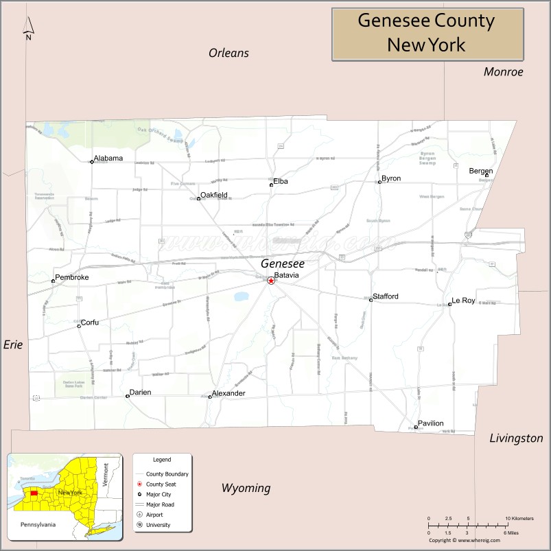
About Genesee County Map, New York: The map showing the county boundary, county seat, major cities, highways, water bodies and neighbouring counties.
Related NY Maps & Info
About Genesee County, New York
Genesee County is a county located in the U.S. state of New York. It's county seat is Batavia. As per 2020 census, the population of Genesee County is 57853 people and population density is 116.87 square miles. According to the United States Census Bureau, the county has a total area of 495 sq mi (1,282 km2). Genesee County was established on 1802.
Facts about Genesee County, New York
| Country | United States |
| State | New York |
| Region | Western New York / Finger Lakes area |
| County Seat | Batavia |
| Founded | March 30, 1802 |
| Organized | March 1803 |
| Named For | Seneca word *Gen-nis’-hee-yo* meaning “beautiful valley” |
| Coordinates | 42.99° N, 78.18° W |
| Total Area | 495 sq mi |
| Land Area | 493 sq mi |
| Water Area | 2.4 sq mi |
| Water % | 0.5% |
| Population (2020) | 58,388 |
| Estimated Population (2024) | 58,000+ |
| Population Density | 118/sq mi |
| Largest City | Batavia |
| Other Towns & Villages | Le Roy, Bergen, Oakfield, Elba, Corfu, Alexander, Pavilion, Bethany, Byron, Stafford, Pembroke |
| Main Industries | Agriculture, Manufacturing, Services, Tourism |
| Major Highways | I‑90, U.S. 20, NY‑33, NY‑98, NY‑63 |
| Time Zone | Eastern Time (UTC−05:00) |
| Known For | Genesee Valley’s fertile farmland, Darien Lake theme park, Genesee County Park & Forest, historic Batavia |
| Website | https://www.geneseeny.gov/Home |
Top Attractions in Genesee County, New York
- Genesee Country Village & Museum – Living history museum.
- Darien Lakes State Park – Camping and outdoor recreation.
- Holland Land Office Museum – Local history and archives.
- Batavia Downs Gaming – Harness racing and casino.
- Tonawanda Wildlife Management Area – Wildlife viewing and trails.
- Batavia City Centre – Downtown shops and dining.
- Richmond Memorial Library – Historic library building.
- St. Paul’s Episcopal Church – Historic architecture.
- Palm Island Indoor Waterpark (nearby) – Family water attraction.
- Oak Orchard Creek – Fishing and paddling.
- DeWitt Recreation Area – Trails and picnic areas.
- Batavia Peace Garden – Quiet downtown garden.
Cities & Towns in Genesee County, New York
Batavia, Le Roy, Bergen, Alexander, Oakfield, Byron, Pavilion, Corfu, Darien, Elba, Stafford, Pembroke, Bethany, Attica (partly)
- Albany County Map
- Allegany County Map
- Bronx County Map
- Broome County Map
- Cattaraugus County Map
- Cayuga County Map
- Chautauqua County Map
- Chemung County Map
- Chenango County Map
- Clinton County Map
- Columbia County Map
- Cortland County Map
- Delaware County Map
- Dutchess County Map
- Erie County Map
- Essex County Map
- Franklin County Map
- Fulton County Map
- Genesee County Map
- Greene County Map
- Hamilton County Map
- Herkimer County Map
- Jefferson County Map
- Kings County Map
- Lewis County Map
- Livingston County Map
- Madison County Map
- Monroe County Map
- Montgomery County Map
- Nassau County Map
- New York County Map
- Niagara County Map
- Oneida County Map
- Onondaga County Map
- Ontario County Map
- Orange County Map
- Orleans County Map
- Oswego County Map
- Otsego County Map
- Putnam County Map
- Queens County Map
- Rensselaer County Map
- Richmond County Map
- Rockland County Map
- St Lawrence County Map
- Saratoga County Map
- Schenectady County Map
- Schoharie County Map
- Schuyler County Map
- Seneca County Map
- Steuben County Map
- Suffolk County Map
- Sullivan County Map
- Tioga County Map
- Tompkins County Map
- Ulster County Map
- Warren County Map
- Washington County Map
- Wayne County Map
- Westchester County Map
- Wyoming County Map
- Yates County Map
- Alabama Counties
- Alaska boroughs
- Arizona Counties
- Arkansas Counties
- California County Map
- Colorado Counties
- Connecticut Counties
- Delaware Counties
- Florida County Map
- Georgia County Map
- Hawaii Counties
- Idaho Counties
- Illinois Counties
- Indiana Counties
- Iowa Counties
- Kansas Counties
- Kentucky Counties
- Louisiana Counties
- Maine Counties
- Maryland Counties
- Massachusetts Counties
- Michigan County Map
- Minnesota Counties
- Mississippi Counties
- Missouri Counties
- Montana Counties
- Nebraska Counties
- Nevada Counties
- New York Counties
- New Hampshire Counties
- New Jersey Counties
- New Mexico Counties
- North Carolina Counties
- North Dakota Counties
- Ohio County Map
- Oklahoma Counties
- Oregon Counties
- Pennsylvania Counties
- Rhode Island Counties
- South Carolina Counties
- South Dakota Counties
- Map of Tennessee
- Texas County Map
- Utah Counties
- Vermont Counties
- Virginia Counties
- Washington Counties
- West Virginia Counties
- Wisconsin Counties
- Wyoming Counties